Method for compensating radar image dual-aspect information

A compensation method and radar image technology, applied in the direction of radio wave reflection/re-radiation, utilization of re-radiation, measurement devices, etc., can solve the problems of backscatter coefficient distortion and inability to eliminate, so as to improve the utilization level and solve the problem of backward Effect of Scattering Coefficient Distortion

Inactive Publication Date: 2012-08-08
INST OF REMOTE SENSING & DIGITAL EARTH CHINESE ACADEMY OF SCI
View PDF3 Cites 15 Cited by
  • Summary
  • Abstract
  • Description
  • Claims
  • Application Information

AI Technical Summary

Problems solved by technology

[0023] The purpose of the present invention is to propose a radar image dual-view information compensation method to solve the problems in the prior art that cannot solve the p

Method used


Image

  • Method for compensating radar image dual-aspect information
  • Method for compensating radar image dual-aspect information
  • Method for compensating radar image dual-aspect information

Examples


Embodiment Construction

[0061] The technical solutions of the present invention will be further described below in conjunction with the accompanying drawings and through specific implementation methods.
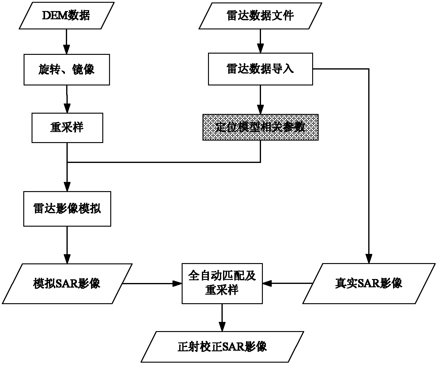
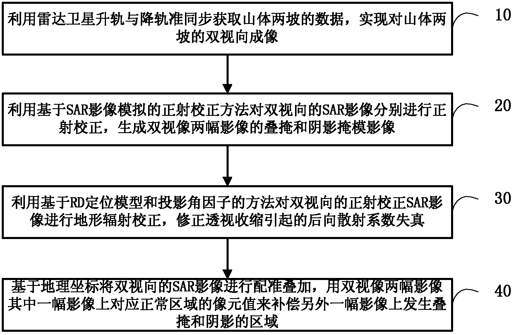
[0062] The main idea of ​​the technical solution of the present invention is to develop a new SAR image dual-view information compensation for the distortion and loss of information on the image caused by the effects of overlapping, perspective shrinkage, and shadows on the SAR image in mountainous areas with large terrain fluctuations. The method solves the problem of backscattering energy distortion caused by perspective shrinkage, the problem of information loss in overlapping and shadow areas, and improves the utilization rate of SAR data in areas with complex terrain.

[0063] The scheme of the present invention is mainly divided into the following four steps: the first step is to use the radar satellite to ascend and descend the orbit to obtain the data of the east and west slopes of the mounta...


PUM


Abstract

The invention discloses a method for compensating radar image dual-aspect information. The method comprises the following steps: acquiring data of two mountainsides of a mountain in a quasi-synchronization manner by using a rise orbit and a decline orbit of a radar satellite to realize dual-aspect imaging of the two mountainsides of the mountain; performing orthorectification on dual-aspected SARimages respectively by using the orthorectification method based on SAR image simulation to generate layover and shadow mask images of the two dual-aspected images; performing topographic radiation correction on the dual-aspected orthorectificated SAR images by using a method based on the RD positioning model and a projection angle factor to correct backscattering coefficient distortion caused byforeshortening; performing registration superposition on the dual-aspected SAR images based on geographic coordinates to compensate layover and shadow regions on one image of the two dual-aspected images by using pixel values of corresponding normal regions on another image of the two dual-aspected images. By adopting the technical scheme provided in the invention, information loss problem on onepicture, such as layover, shadow, etc., caused by topography can be compensated effectively, and the backscattering coefficient distortion problem caused by the foreshortening phenomenon is solved.

Description

technical field [0001] The invention relates to the technical field of radar imaging, in particular to a method for compensating radar image dual-view information. Background technique [0002] Synthetic Aperture Radar (SAR, Synthetic Aperture Radar) has the characteristics of all-weather, all-weather and certain penetration to certain ground objects, and has been widely used in ocean, atmosphere, land, ice and snow, space detection and military. application. Especially for topographic surveying and mapping in southwestern my country with complex topography, rapid update of topographic maps and dynamic monitoring of land use in cloudy and rainy areas in southern my country, SAR is even the only feasible solution. However, due to the oblique range imaging characteristics of SAR, geometric distortion features that are significantly different from optical remote sensing images will appear on SAR images, including perspective contraction, overlapping and shadows. These geometr...

Claims


Application Information

Patent Timeline
IPC IPC(8): G01S13/90
Inventor 邵芸张风丽万紫王国军刘龙
Owner INST OF REMOTE SENSING & DIGITAL EARTH CHINESE ACADEMY OF SCI
Why Eureka
Try Eureka