Method for quickly extracting building three-dimensional outline information in onboard LiDAR (light detection and ranging) data

A technology for 3D contours and buildings, applied in 3D modeling, image data processing, instruments, etc., can solve the problems affecting the expansion and application of airborne LiDAR technology, and the development of data processing methods is lagging behind, so as to improve the efficiency of the algorithm and shorten the operation time. time, the effect of reducing complexity

Inactive Publication Date: 2013-02-06
李慧盈 +2
View PDF1 Cites 25 Cited by
  • Summary
  • Abstract
  • Description
  • Claims
  • Application Information

AI Technical Summary

Problems solved by technology

Traditional surveying and mapping technology cannot meet the current needs in terms of speed and accuracy. Airborne LiDAR (Light Detection And Ranging) is an active remote sensing measurement technology. By measuring the propagation time of laser pulses, combined with the POS system (by differential The pose information provided by GPS and inertial navigation system INS) can directly obtain high-precision three-dimensional coordinates of ground objects
Airborne LiDAR technology is relatively mature in terms of hardware, but the development of supporting data processing methods is relatively lagging behind, which seriously affects the extended application of airborne LiDAR technology.

Method used


Image

  • Method for quickly extracting building three-dimensional outline information in onboard LiDAR (light detection and ranging) data
  • Method for quickly extracting building three-dimensional outline information in onboard LiDAR (light detection and ranging) data
  • Method for quickly extracting building three-dimensional outline information in onboard LiDAR (light detection and ranging) data

Examples


Embodiment Construction

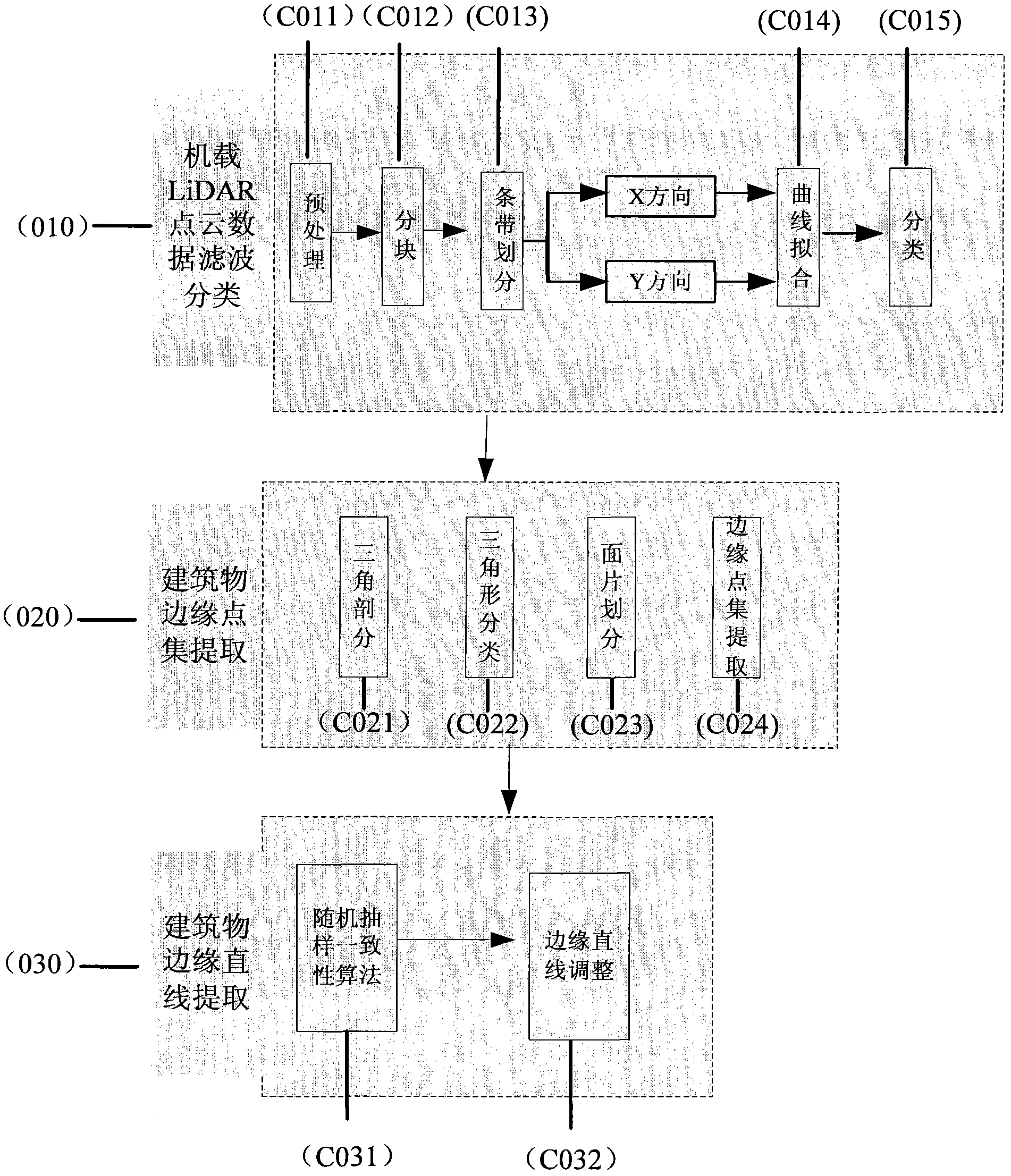
[0035] The processing flow of building outline information extraction from airborne LiDAR 3D point cloud data is as follows: figure 1 As shown, the processing flow is divided into three parts:

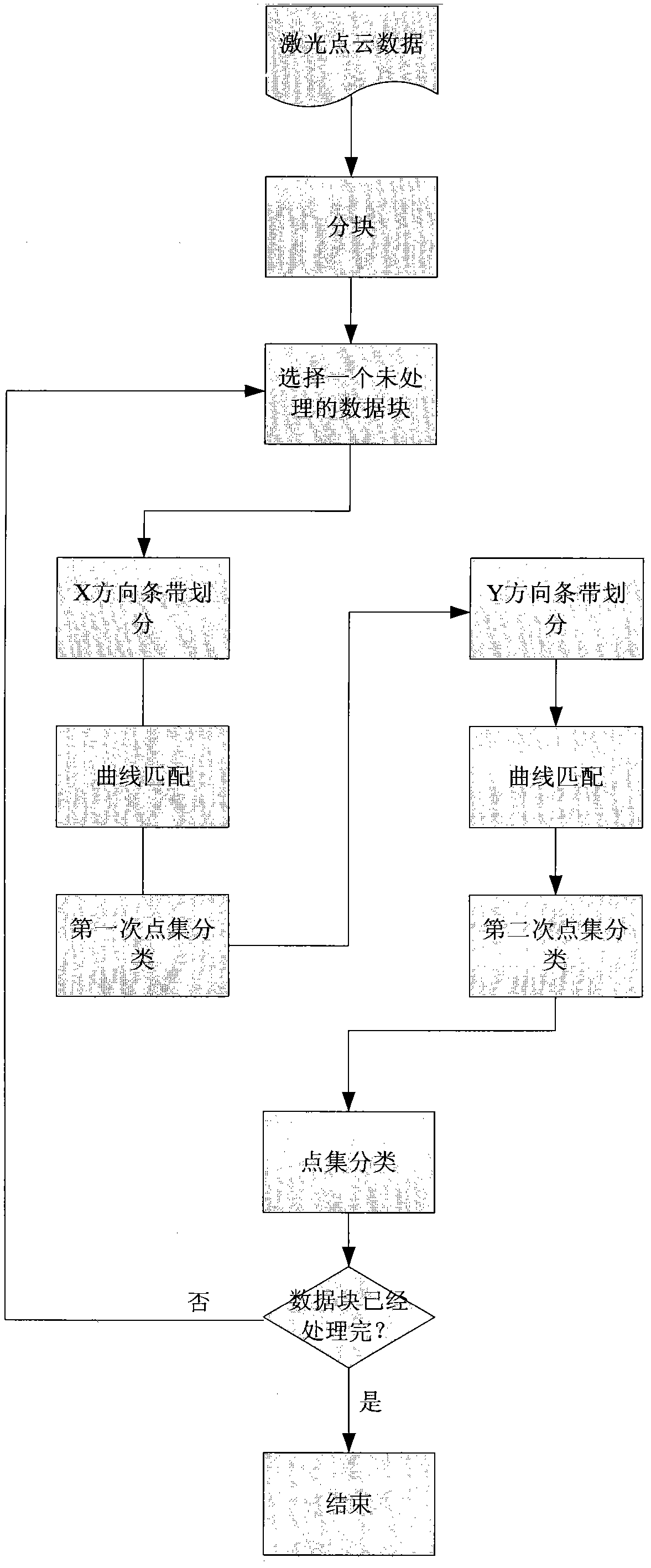
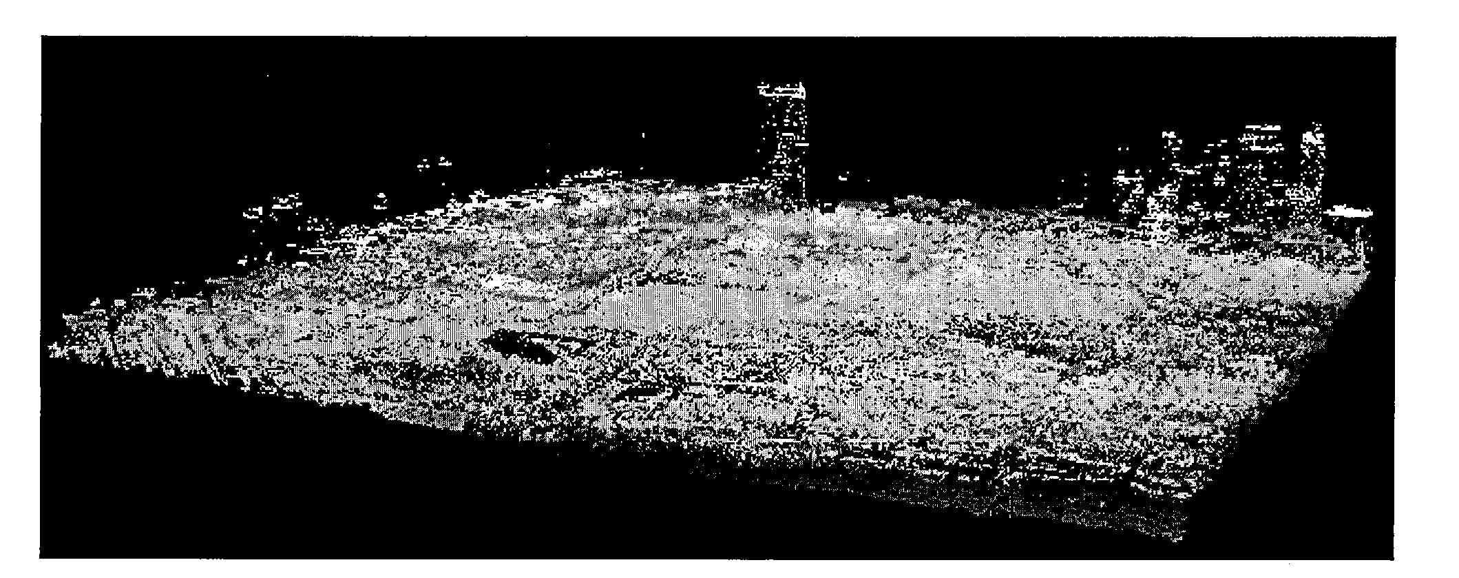
[0036] 1. The processing flow of airborne LiDAR 3D point cloud data filtering and classification (C010) is as follows: figure 2 Shown: first read as image 3The airborne LiDAR three-dimensional point cloud data shown, and then the airborne LiDAR three-dimensional point cloud data is preprocessed (C011); read the airborne LiDAR three-dimensional point cloud data to obtain the total number of airborne LiDAR three-dimensional points, and The most value of the coordinates; then the original point cloud is divided into blocks (C012), which is convenient for computer processing; then two strips are divided (C013), and each data block is divided into strips in the X direction and the Y direction. The width of the strip is 3m; finally, curve fitting (C013) is performed on each divided strip...


PUM


Abstract

The invention discloses a novel method for extracting building three-dimensional outline information by utilizing a stripe division method to quickly filter onboard LiDAR (light detection and ranging) point cloud data, and based on a random sampling consistency model. In the method, in allusion to high precision of the onboard LiDAR data per se, the mass onboard LiDAR point cloud data is directly processed; the method comprises the steps as follows: firstly performing classification filtering on the onboard LiDAR three-dimensional point cloud data through two-time stripe division in X direction and Y direction, so as to distinguish ground points from non-ground points; then performing triangulation on the non-ground three-dimensional point cloud data, and dividing building roof surface patches through the combination with the classification result, extracting LiDAR point sets contained in each building, and then, obtaining a edge point set of each building through edge tracking; and finally, using the random sampling consistency model to extract building edge straight lines from the edge point sets and form a building outline characteristic curve, so as to meet working requirements of digital city three-dimensional modeling and the like.

Description

technical field [0001] The invention belongs to the field of earth observation, and relates to a method for quickly extracting three-dimensional outline information of buildings in airborne LiDAR data, which is suitable for rapidly extracting building outlines from large-scale airborne LiDAR point cloud data in urban areas, and can be applied to Digital city 3D modeling and other work. Background technique [0002] With the continuous expansion of spatial data application fields and the rapid improvement of people's application requirements, it is becoming more and more urgent to quickly and accurately extract urban building information. Traditional surveying and mapping technology cannot meet the current needs in terms of speed and accuracy. Airborne LiDAR (Light Detection And Ranging) is an active remote sensing measurement technology. By measuring the propagation time of laser pulses, combined with the POS system (by differential The pose information provided by GPS and ...

Claims


Application Information

Patent Timeline
Patent Type & Authority Applications(China)
IPC IPC(8): G06T17/00G06T19/00
Inventor 李慧盈王植李德昌
Owner 李慧盈
Why Eureka
Try Eureka