Ratio method for correcting topographic influence in electromagnetic prospecting

A terrain and ratio technology, applied in the field of electrical and electromagnetic prospecting, can solve the problems of poor correction effect, large amount of calculation, cumbersome implementation, etc., and achieve the effect of avoiding the introduction of errors, improving the correction effect, and saving the model building process

Active Publication Date: 2013-04-24
JIANGSU UNIV
View PDF3 Cites 14 Cited by
  • Summary
  • Abstract
  • Description
  • Claims
  • Application Information

AI Technical Summary

Problems solved by technology

[0012] In order to overcome the defects of poor correction effect, huge amount of calculation and cumbersome implementation in the prior art, the pres

Method used


Image

  • Ratio method for correcting topographic influence in electromagnetic prospecting
  • Ratio method for correcting topographic influence in electromagnetic prospecting
  • Ratio method for correcting topographic influence in electromagnetic prospecting

Examples


Embodiment 1

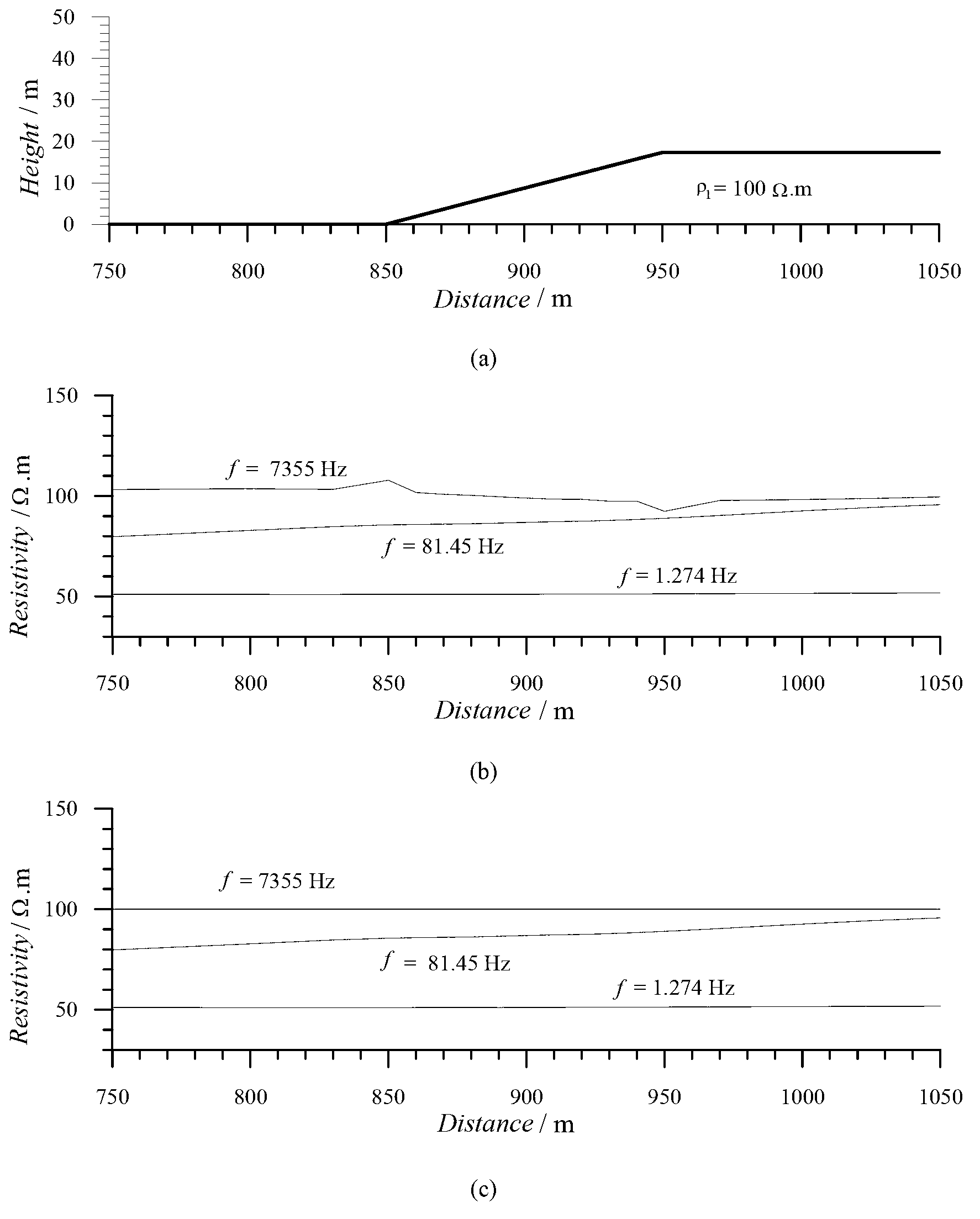
[0038] Simulation of pure terrain effect correction for CSAMT uniform earth, uniform earth resistivity ρ 1 =100Ω·m, using electric dipole source and boundary element numerical simulation electric field E x Component, the far field apparent resistivity definition.

[0039] Step 1, since this example is a pure terrain response simulation of uniform earth, the surface resistivity is the same as the uniform earth resistivity, so the uniform earth resistivity ρ 1 =100Ω·m as the standard resistivity ρ for terrain correction standard (i);

[0040] Step 2, draw topographic profile 1(a) and apparent resistivity profile figure 1 (b) for comparison. The basic law of the influence of topography on CSAMT is: the apparent resistivity profile curve is opposite to the change of topographic relief, that is, the apparent resistivity rises when the topography descends, the apparent resistivity decreases when the topography rises, and the apparent resistivity changes sharply when the topograp...

Embodiment 2

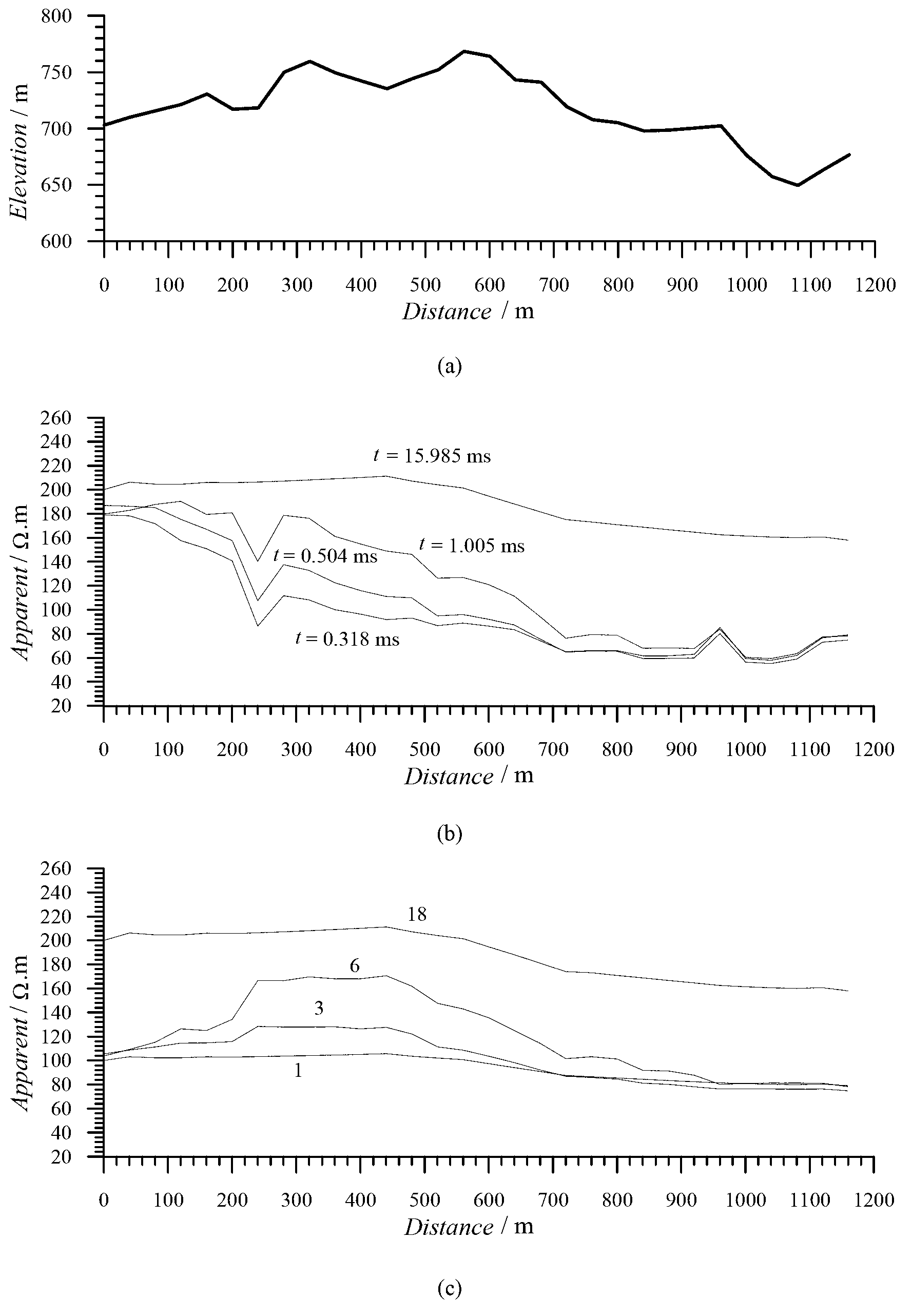
[0046] Example 2. Topographic correction of measured TEM mountain exploration data, center loop device: transmitting wire frame 600m×600m, receiving coil equivalent area 100m 2 , observation time 30ms, 20 channels.

[0047] Step 1: Obtain the surface resistivity value of each measuring point without terrain influence by applying the small pole moment DC resistivity method, as shown in Table 2.

[0048] Table 2 The surface resistivity values ​​of each measuring point obtained by the small pole moment DC resistivity method

[0049] Measuring point / m

Resistivity / Ω.m

Measuring point / m

Resistivity / Ω.m

Measuring point / m

Resistivity / Ω.m

Measuring point / m

Resistivity / Ω.m

0

100.00

320

104.00

640

94.000

960

81.242

40

103.10

360

104.50

680

90.750

1000

80.700

80

102.26

400

105.00

720

87.500

1040

80.250

120

102.25

440

105.62

7...


PUM


Abstract

The invention discloses a ratio method for correcting topographic influence in electromagnetic prospecting. The ratio method comprises the steps of acquiring a surface layer resistivity value without topographic influence to serve as a standard resistivity of topographic correction; drawing an in-line topographic profile, respectively comparing the topographic profile with a frequency point profile of a frequency domain electromagnetic method and a time channel profile of a time domain electromagnetic method, and judging the topographic influence suffered by the actually measured data according to the influence rule of the topography on the resistivity in the frequency domain and the time domain electromagnetic field; observing from the highest frequency point of the frequency domain electromagnetic method and the earliest time channel of the time domain electromagnetic method so as to obtain the topographic response which is closest to the surface layer until the absence of low-frequency frequency point of the topographic influence is observed in the frequency domain electromagnetic method and the absence of the late time channel of the topographic influence is observed in the time domain electromagnetic method, and acquiring the observation data without topographic influence; and performing topographic correction according to a ratio formula of pcorrected(i,j)=pmeasured(i,j) [pstandard(i)/pmeasured(i,l)]C(i,j). The ratio method is good in correction effect in the process of correcting the topographic influence, is high in feasibility and can be widely applied to topographic influence correction in electromagnetic prospecting.

Description

technical field [0001] The invention belongs to the field of geophysical prospecting, and in particular relates to an electric and electromagnetic prospecting method. Background technique [0002] Terrain influence correction is an important issue in the processing and interpretation of electromagnetic mountain prospecting data such as CSAMT (Controlled Source Audio-frequency Magneto-Telluric), MT (Magneto-Telluric), TEM (Transient Electro-Magnetic), and is an important issue for improving the accuracy of mountain prospecting, obtaining The key to good geological results. The existing mainstream terrain influence correction technology for electromagnetic prospecting includes the ratio method [1] and 2D or 3D inversion with terrain [2] method. Among them, the ratio method uses numerical methods such as boundary element, finite element, finite difference, and time-domain finite difference to simulate the pure terrain response of the uniform earth, and then compares the unif...

Claims


Application Information

Patent Timeline
IPC IPC(8): G01V3/38
Inventor 闫述
Owner JIANGSU UNIV
Why Eureka
Try Eureka