Air data and gesture heading reference system for flight navigation

A technology of atmospheric data and reference system, applied in the field of flight navigation, to achieve the effect of low price, light weight and small volume

Active Publication Date: 2013-05-01
TAIYUAN AERO INSTR
View PDF5 Cites 10 Cited by
  • Summary
  • Abstract
  • Description
  • Claims
  • Application Information

AI Technical Summary

Problems solved by technology

[0003] In order to solve the above-mentioned problems existing in the existing flight navigation methods, th

Method used


Image

  • Air data and gesture heading reference system for flight navigation
  • Air data and gesture heading reference system for flight navigation

Examples


Example Embodiment

[0015] The specific embodiment of the present invention will be further described in conjunction with the accompanying drawings.

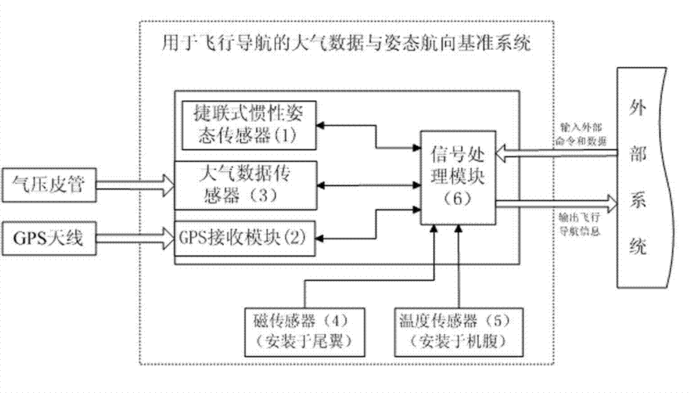
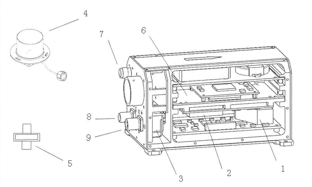
[0016] The air data and attitude heading reference system for flight navigation is characterized in that it includes a strapdown inertial attitude sensor 1, a GPS receiving module 2, an air data sensor 3, a magnetic sensor 4, a temperature sensor 5 and a signal processing module 6, the The input and output ends of the inertial attitude sensor 1, the GPS receiving module 2 and the air data sensor 3 are all connected with the signal processing module 6, and the output ends of the magnetic sensor 4 and the temperature sensor 5 are connected with the signal processing module 6, and the strapdown inertia The installation direction of the attitude sensor 1 is aligned with the body coordinates of the aircraft, the GPS receiving module 2 is connected to the external antenna through the GPS antenna interface 7, and the air data sensor 3 is connected to t...


PUM


Abstract

The invention belongs to the technical field of flight navigation and in particular relates to an air data and gesture heading reference system for flight navigation. The system solves the problems in the conventional flight navigation mode. The system comprises a strapdown type inertial gesture sensor, a global positioning system (GPS) system receiving module, an air data sensor, a magnetic sensor, a temperature sensor and a signal processing module, wherein the input ends and the output ends of the inertial gesture sensor, the GPS receiving module and the air data sensor are connected with the signal processing module; and the output ends of the magnetic sensors and the temperature sensors are connected with the signal processing module. The system has the benefits that the gesture sensor has autonomy and can make up the defects that the GPS is limited by the topography and susceptible to interference; the GPS has real-time property and can make up the defect that the error of the gesture sensor is accumulated along with the time; the air data sensor provides high-precision air data and can be used for correcting the gesture information of the system; and the system has small size and light weight.

Description

technical field [0001] The invention belongs to the technical field of flight navigation, and in particular relates to an atmospheric data and attitude heading reference system for flight navigation. Background technique [0002] At present, the flight navigation methods mainly include radio navigation, platform inertial navigation, strapdown inertial navigation, satellite system navigation, etc. Each navigation method has its own advantages and disadvantages. Radio navigation is susceptible to interference; platform inertial navigation is bulky and expensive, and is not suitable for general navigation; strapdown inertial navigation is moderately priced, but its accuracy is relatively low when used alone; satellite system navigation is limited by terrain and is susceptible to interference. Therefore, it is a trend in the field of navigation to integrate several different navigation methods and learn from each other, and it is also a key technology of general aviation navigat...

Claims


Application Information

Patent Timeline
IPC IPC(8): G01C21/00G01C21/16
Inventor 宣晓刚祝陶然丰新龙杨晓飞
Owner TAIYUAN AERO INSTR
Why Eureka
Try Eureka