Accurate detection method for submarine large complex sandwave landforms

A detection method and complex technology, applied in 3D image processing, image data processing, instruments, etc., can solve the problem of difficult accurate detection of seabed sand wave topography

Active Publication Date: 2014-07-09
SECOND INST OF OCEANOGRAPHY MNR
View PDF2 Cites 0 Cited by
  • Summary
  • Abstract
  • Description
  • Claims
  • Application Information

AI Technical Summary

Problems solved by technology

[0005] Aiming at the problem that the seabed sand wave landform is difficult to accurately detect and its components are complex, the present invention proposes an accurate detection and FFT decomposition method for large and complex seabed sand wave landforms

Method used


Image

  • Accurate detection method for submarine large complex sandwave landforms
  • Accurate detection method for submarine large complex sandwave landforms
  • Accurate detection method for submarine large complex sandwave landforms

Examples


Embodiment 1

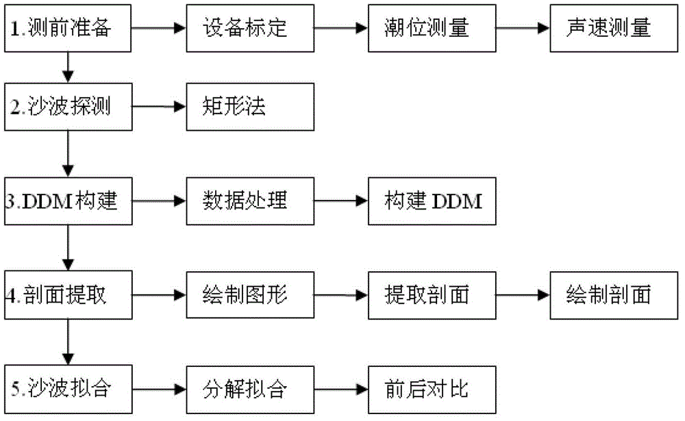
[0052] The precise detection and FFT decomposition method of large and complex sand wave landforms on the seabed are realized according to the following steps.

[0053] Detailed steps and flow process of the present invention are as figure 1 shown.

[0054] Step 1: Preparation before seabed sand wave detection

[0055] (1) Equipment testing and calibration: The multi-beam bathymetry system is a complex submarine topography detection system. Multi-beam water depth detectors, length measuring instruments, and sound velocity measuring instruments are selected. All instruments and equipment must be in accordance with national standards before measurement. GB / T12763.10-2007 conducts self-calibration or sends it to a legal metrology institution for calibration to ensure that all sensors are in normal working condition and that the accuracy of the instrument meets the requirements of the national standard. The depth-sounding accuracy of the multi-beam system reaches the decimeter l...


PUM


Abstract

The invention discloses a survey research method for hydrographic surveying and charting and submarine landforms, and specifically relates to an accurate detection method for submarine large complex sandwave landforms. The method disclosed by the invention comprises the following steps: through a specific detecting instrument, determining the layout of a tide station, and carrying out sound velocity profile survey; then, carrying out submarine sandwave landform detection; establishing a submarine DDM according to detected data; carrying out sandwave character extraction based on the submarine DDM; and finally, carrying out profile-based sandwave FFT (fast Fourier transform algorithm) decomposition and fitting. The method disclosed by the invention has the advantages that a fine detection scheme for submarine sandwave characters is solved, and a frequency decomposition and fitting method for submarine sandwaves is further given. The method disclosed by the invention has an important practical application value in marine engineering construction, hydrographic surveying and charting, oceanographic survey, and submarine scientific researches, and achieves an actual application effect in the detection, decomposition and fitting of various sandwaves such as cycloid sandwaves, bimodal sandwaves and cosine sandwaves and the like.

Description

technical field [0001] The invention relates to the technical fields of marine surveying and mapping, investigation and research of seabed topography and geomorphology, and seabed science, and specifically refers to an accurate detection method for large and complex sand wave landforms on the seabed. Background technique [0002] Submarine sand wave is a kind of seabed form widely distributed in the tidal environment, and it is a type of seabed landform with strong activity. The appearance of seabed sand wave represents the strong activity of the seabed. The characteristic shape of sand waves developed on the seabed is considered to be the shape in which the sediments on the seabed are deformed to adapt to the shearing action of the water flow, thus causing the bed to change regularly. Studying the characteristics and laws of sand waves has extremely important application value for the safety assessment of marine engineering construction such as submarine pipelines and oil p...

Claims


Application Information

Patent Timeline
Patent Type & Authority Patents(China)
IPC IPC(8): G06T7/00G06T15/00
Inventor 吴自银余威尚继宏李守军赵荻能周洁琼金肖兵
Owner SECOND INST OF OCEANOGRAPHY MNR
Why Eureka
Try Eureka