
Target low elevation estimation method based on real number field generalized multiple-signal sorting algorithm

A technology of multiple signal classification and real number domain, applied in the field of low elevation angle estimation of targets, can solve problems such as difficult to realize real-time signal processing, large amount of calculation, unfavorable engineering application, etc.

Inactive Publication Date: 2013-10-23
XIDIAN UNIV
View PDF4 Cites 21 Cited by
  • Summary
  • Abstract
  • Description
  • Claims
  • Application Information

AI Technical Summary

Problems solved by technology

Although this method has high accuracy in estimating the elevation angle of low-altitude targets, it requires a two-dimensional angle search in the complex domain of the spatial spectral function, which requires a large amount of calculation.
Especially for low-altitude and high-speed targets, such as anti-ship missiles, combat aircraft, etc., this method is difficult to achieve real-time signal processing, which is not conducive to engineering applications

Method used


Image

  • Target low elevation estimation method based on real number field generalized multiple-signal sorting algorithm
  • Target low elevation estimation method based on real number field generalized multiple-signal sorting algorithm
  • Target low elevation estimation method based on real number field generalized multiple-signal sorting algorithm

Examples


Embodiment Construction

[0041] refer to figure 1 , the implementation steps of the present invention are as follows:

[0042] Step 1, receiving target echo signals.

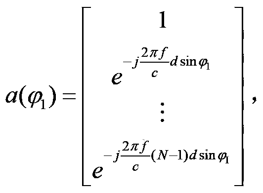
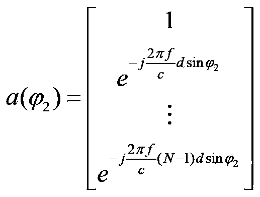
[0043] An equidistant linear array is designed in the pitch direction of the phased array radar. The line array is composed of N array elements. These array elements are arranged at equal intervals in the pitch direction, and they are all non-directional array elements. Target echo signal in the direction.

[0044] Step 2, obtain the sampling data of the distance unit where the target is located.

[0045] Digitally sample the echo signal received by the line array, determine the distance unit of the target through the target detection technology, and obtain the sampling data x n (l), wherein, n=1,2,...N, l=1,2,...L, L is the total snapshot number of sampling data;

[0046] Step 3, using sampled data x n (l), to obtain the sampling covariance matrix

[0047] (3a) The sampling data of N array elements x 1 (l),x 2 (l),...,x N (l),...


PUM


Abstract

The invention discloses a target low elevation estimation method based on a real number field generalized multiple-signal sorting algorithm. The target low elevation estimation method includes the implementation steps of (1) sampling radar received back waves, (2) using sample data to calculate a sampling covariance matrix, (3) carrying out spatial smoothing and unitary transformation on the sampling covariance matrix to obtain a real number field covariance matrix (4) carrying out eigenvalue decomposition on the real number field covariance matrix to obtain a noise projection matrix, (5) constructing a real number field guiding vector manifold, (6) using the noise projection matrix and the real number field guiding vector manifold to constructing a spatial spectrum, conducting two-dimensional angle searching on the spatial spectrum and obtaining an initial angle estimated value, (7) using the initial angle estimated value to estimate a multi-path attenuation coefficient, constructing a secondary spatial spectrum and obtaining an angle estimated value through the two-dimensional angle searching, and (8) comparing the two angles in the estimated values, and considering the maximum angle as the target elevation value. According to the target low elevation estimation method, the algorithm complexity is reduced, and the angle estimation performance of a radar under the low signal-to-noise ratio is improved.

Description

technical field [0001] The invention belongs to the technical field of radar signal processing, and in particular relates to a method for estimating a low elevation angle of a target, which can be used for radar detection and tracking of a target in a multipath environment. Background technique [0002] In the detection and tracking of low-altitude targets by radar, the target elevation angle is a very important measurement parameter. Only by accurately estimating the target elevation angle can the stable tracking of the target be realized. When measuring and tracking low-altitude targets, in addition to receiving the direct signal returned by the target, the radar will also receive the reflected signal generated by the ground or sea surface, resulting in multipath effects, resulting in angle measurement errors, and even loss of tracking targets. Since the direct signal and the reflected signal are coherent signals, and for long-distance low-altitude targets, the angle of ar...

Claims


Application Information

Patent Timeline
IPC IPC(8): G01S7/41
Inventor 刘峥王园园曹运合谢荣
Owner XIDIAN UNIV
Learn More