Road zebra crossing automatic extraction method based on vehicle-mounted laser scanning point cloud

A vehicle-mounted laser scanning and automatic extraction technology, applied in image analysis, instrumentation, computing, etc., to achieve the effect of reducing data processing time and labor costs, reducing complexity, and reducing the amount of calculation.

Active Publication Date: 2014-01-08
XIAMEN UNIV
View PDF3 Cites 56 Cited by
  • Summary
  • Abstract
  • Description
  • Claims
  • Application Information

AI Technical Summary

Problems solved by technology

[0005] However, how to extract terrain and feature features from vehicle-mounted point cloud data with high density and large data volume has become a challenge in the development of point cloud post-processing software.

Method used


Image

  • Road zebra crossing automatic extraction method based on vehicle-mounted laser scanning point cloud
  • Road zebra crossing automatic extraction method based on vehicle-mounted laser scanning point cloud
  • Road zebra crossing automatic extraction method based on vehicle-mounted laser scanning point cloud

Examples


Embodiment Construction

[0018] Concrete technical scheme of the present invention and implementation steps are as follows:

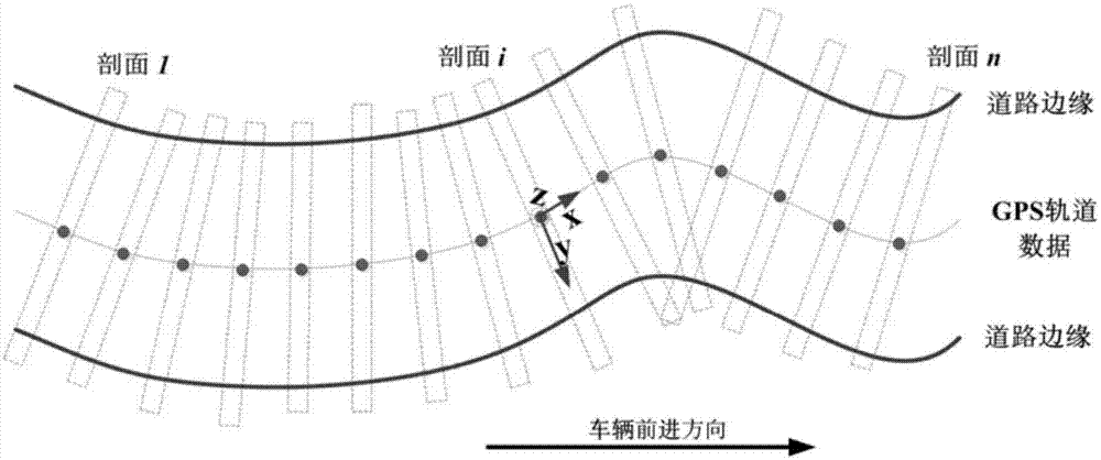
[0019] Step 1: According to the GPS data recording the position and trajectory of the vehicle equipped with the laser scanner, the point cloud data is cross-sectioned at a certain distance (such as 3m) to a thin section with a width of about 30cm. In this way, several cross-sectional profile data can be obtained along the GPS track data of the vehicle, such as figure 1 shown. exist figure 1 In , the arrow indicates the forward direction of the vehicle.

[0020] Step 2: For each profile (in figure 1 , expressed as section 1...section i...section n), rasterization is performed, and the principal component points in each grid are selected to form scan lines. In order to determine the principal component points in each grid, the point cloud in the grid is quickly sorted according to its elevation. Based on the assumption that the elevation difference between road points is sma...


PUM


Abstract

The invention provides a road zebra crossing automatic extraction method based on vehicle-mounted laser scanning point cloud, and relates to public traffic road zebra crossings. According to the method, global positioning system data for recording vehicle positions and tracks in real time is used for extracting a plurality of cross sections from the vehicle-mounted laser scanning point cloud data, and the road and non-road classification is realized through detecting the elevation mutation of road shoulders of the roads in the scanning line data; then, the three-dimension road data is converted into an intensity characteristic image with space distribution characteristics, the laser scanning point normal distribution characteristics are utilized for dynamically cutting the road zebra crossings, the GPS (global positioning system) track data is used again for calculating the linear morphology closed operation direction and size, and the extraction of the road zebra crossings is realized. Through the cross section subdivision on the vehicle-mounted moving scanning data, and the three-dimension road surface data detection is converted into the detection of the elevation mutation of the road shoulders of the roads in the two-dimension profile for realizing the road and non-road classification. Compared with a method of directly processing mass three-dimension data, the method has the advantages that the calculation quantity is small, and the efficiency is high.

Description

technical field [0001] The invention relates to the field of public traffic road zebra crossings, in particular to an automatic extraction method for road zebra crossings based on vehicle-mounted laser scanning point clouds. Background technique [0002] As a key feature of a traffic management system, road zebra crossings require reliable environmental awareness to provide guidance and information for pedestrians and vehicle drivers to prevent accidents, thereby improving traffic safety and reducing loss of life and property. Therefore, the road system department also urgently needs a fast and real-time detection system that can monitor the situation of road zebra crossings, so as to ensure that road zebra crossings meet the high-tech standards of national traffic. [0003] At present, the extraction of road zebra crossings generally adopts methods based on images or videos, and its main steps include segmentation and classification of road zebra crossings. The segmentatio...

Claims


Application Information

Patent Timeline
Patent Type & Authority Applications(China)
IPC IPC(8): G06K9/46G06T7/00
Inventor 管海燕李军于永涛
Owner XIAMEN UNIV
Why Eureka
Try Eureka