Remote Sensing-Based Monitoring Method of Regional Terrestrial Ecosystem Respiration
An ecosystem and regional technology, applied in the field of satellite remote sensing and remote sensing applications, can solve the problems of dependence, heterogeneity and insufficient expressiveness of information, and achieve the effect of improving accuracy
- Summary
- Abstract
- Description
- Claims
- Application Information
AI Technical Summary
Problems solved by technology
Method used
Image
Examples
Embodiment 1
[0049] Taking China (national area) as an example, MODIS satellite remote sensing image data is obtained from NASA (National Aeronautics and Space Administration). The time step is 8 days.
[0050] S1 obtains time series satellite remote sensing image data in China:
[0051] In this embodiment, AVHRR / MODIS (Modified Very High Resolution Radiometer / Modified Resolution Aerospace Imaging Spectrometer) is used as the satellite remote sensing image data source. This is mainly due to the fact that AVHRR / MODIS data has multi-spectral characteristics and a time resolution of 1 day, which can meet the needs of remote sensing monitoring in continuous time series. In order to reduce the influence of cloud cover, the obtained data are 8-day synthetic products of MODIS reflectance in 2001.
[0052] Remote sensing inversion of S2 key parameter FPAR:
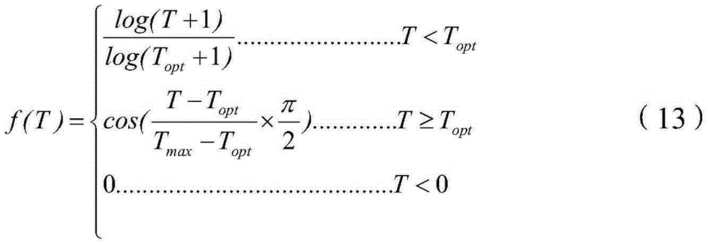
[0053] FPAR=1-α-P gap +P gap alpha b (1-K open )(1)
[0054] P gap =exp(-LAI·Ω(θ sun )·G(θ sun )cosθ sun )(2)
[0055] In formul...
PUM
 Abstract
Description
Claims
Application Information
 - R&D
- Intellectual Property
- Life Sciences
- Materials
- Tech Scout
- Unparalleled Data Quality
- Higher Quality Content
- 60% Fewer Hallucinations
Browse by: Latest US Patents, China's latest patents, Technical Efficacy Thesaurus, Application Domain, Technology Topic, Popular Technical Reports.
© 2025 PatSnap. All rights reserved.Legal|Privacy policy|Modern Slavery Act Transparency Statement|Sitemap|About US| Contact US: help@patsnap.com


