Loose-coupling remote-sensing satellite ground receiving system

A remote sensing satellite and ground receiving technology, which is applied in the field of remote sensing satellite ground system, can solve problems such as difficult to implement, difficult to meet comprehensive remote sensing applications, and poor system scalability, and achieve the effects of flexible use of resources, protection of software and hardware resources, and good autonomy

Inactive Publication Date: 2014-01-29
CENT FOR EARTH OBSERVATION & DIGITAL EARTH CHINESE ACADEMY OF SCI
View PDF2 Cites 10 Cited by
  • Summary
  • Abstract
  • Description
  • Claims
  • Application Information

AI Technical Summary

Problems solved by technology

[0002] The remote sensing satellite ground system includes functions such as reception, transmission, processing, management and distribution of remote sensing data. With the continuous development of remote sensing technology and computer technology, it can be roughly divided into several stages according to the development history of the ground system and the processing structure in different periods , the early ground processing system needs to solve how to process the received data to generate corresponding image products; the main problem to be solved in the second generation ground processing system is how to manage massive data and how to schedule and realize the multi-satellite business processing process Management; the third-generation ground system solves the problem of improving processing capabilities, increasing processing functions, and forming a reconfigurable system structure and hardware and software platform for processing functions. Parallel processing technology and mass data storage technology have begun to be widely used; Coupling architecture, writing software for specific tasks, poor scalability of the system, often involves cross-agency and cross-system interaction and integration in the development of remote sensing comprehensive application systems, and the current tightly coupled satellite ground system is difficult to achieve , it is difficult to meet the needs of comprehensive remote sensing applications, this patent proposes a loosely coupled ground system architecture and method

Method used


Image

  • Loose-coupling remote-sensing satellite ground receiving system
  • Loose-coupling remote-sensing satellite ground receiving system
  • Loose-coupling remote-sensing satellite ground receiving system

Examples


Embodiment Construction

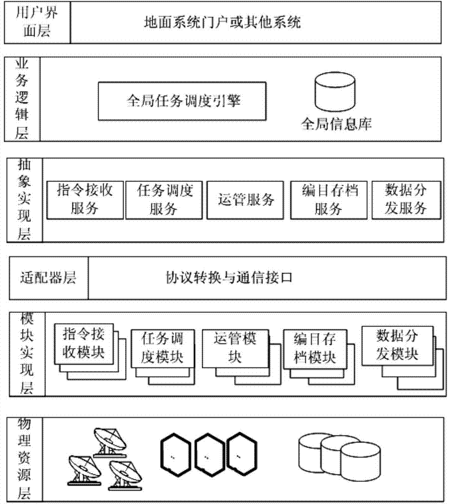
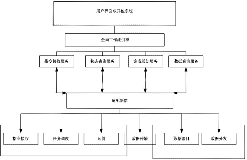
[0027] Such as figure 1 As shown, the loosely coupled remote sensing satellite ground receiving system described in the embodiment of the present invention includes: a physical resource layer that provides the hardware environment of the ground system, a module implementation layer that realizes different module functions in the ground system, and protocol conversion that supports different modules. and communication interface and convert heterogeneous module implementation into an adapter layer for a unified external call interface, an abstract service implementation layer for the abstract realization of each functional module of the satellite ground system, and a business logic call and control through a global task scheduling engine The logic layer and the user interface layer that implements the interaction with the system.

[0028] The module implementation layer includes an instruction receiving module, a task scheduling module, an operation management module, a catalog ...


PUM


Abstract

The invention relates to a loose-coupling remote-sensing satellite ground receiving system. The loose-coupling remote-sensing satellite ground receiving system comprises a physical resource layer, a module implementing layer, an adapter layer, an abstract service implementing layer, a service logic layer and a user interface layer, wherein the physical resource layer provides the ground system hardware environment, the module implementing layer implements different modular functions in the ground system, the adapter layer supports protocol conversion and communication interfaces realized by different modules and converts different-structure modules into unified external calling interfaces, the abstract service implementing layer is used for abstractly implementing various functional modules of the satellite ground system, the service logic layer realizes calling and controlling of service logics through an overall task scheduling engine, and the user interface layer interacts with the system. The loose-coupling remote-sensing satellite ground receiving system has the advantages that the loose-coupling remote-sensing satellite ground receiving system provides a framework applicable to a wide area network, loose-coupling access among various multi-source heterogeneous modules of the satellite ground system is realized, integration and interoperability between the satellite ground system and other remote sensing application systems are realized, and expandability of the satellite ground system is improved.

Description

technical field [0001] The invention relates to the field of remote sensing satellite ground systems, in particular to a loosely coupled remote sensing satellite ground receiving system. Background technique [0002] The remote sensing satellite ground system includes functions such as reception, transmission, processing, management and distribution of remote sensing data. With the continuous development of remote sensing technology and computer technology, it can be roughly divided into several stages according to the development history of the ground system and the processing structure in different periods , the early ground processing system needs to solve how to process the received data to generate corresponding image products; the main problem to be solved in the second generation ground processing system is how to manage massive data and how to schedule and realize the multi-satellite business processing process Management; the third-generation ground system solves th...

Claims


Application Information

Patent Timeline
Patent Type & Authority Applications(China)
IPC IPC(8): G06Q10/06
Inventor 李国庆解吉波邓红帅雷星松杨中
Owner CENT FOR EARTH OBSERVATION & DIGITAL EARTH CHINESE ACADEMY OF SCI
Why Eureka
Try Eureka