Spectral correction method of imaging spectrum reflectivity data

A technology of imaging spectrum and correction method, which is applied in the direction of color/spectral characteristic measurement, etc., can solve the problems of high extraction rate of mineral information extraction, large systematic error, etc., and achieve the effect of reducing the rate of extraction and error

Inactive Publication Date: 2014-02-19
CHINA AERO GEOPHYSICAL SURVEY & REMOTE SENSING CENT FOR LAND & RESOURCES
View PDF4 Cites 11 Cited by
  • Summary
  • Abstract
  • Description
  • Claims
  • Application Information

AI Technical Summary

Problems solved by technology

[0003] However, due to instrument calibration errors, multiple reflections of energy between the ground and the atmosphere, etc., there are often large systematic errors between the obtained surface reflectance and the ground measured data, resulting in a high rate of mineral information extraction.

Method used


Image

  • Spectral correction method of imaging spectrum reflectivity data

Examples


Embodiment Construction

[0020] In order to better illustrate the method and steps of the present invention, a correction test was carried out using the HyMap airborne imaging spectral reflectance data in a certain area and the ground measured spectral data in 12 different locations as examples. The equipment used in the test is a graphics workstation, the specification model is Dell Precision 4700, the operating system is WindowsXP (64-bit), the CPU is 2.66GHz, the content is 32GB, and the hard disk is 1T.

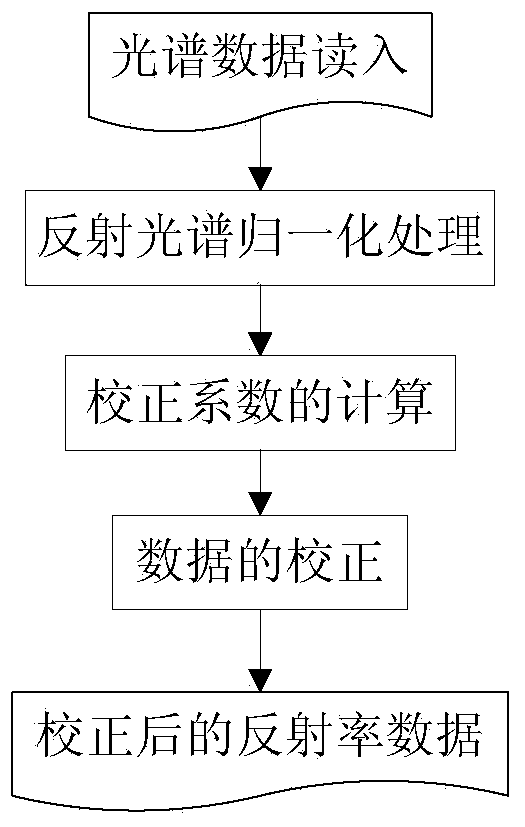
[0021] See figure 1 , a spectral correction method of imaging spectral reflectance data of the present invention, its specific steps are as follows:

[0022] Step 1, read in the data, the spectral range of ground measured spectrum and HyMap imaging spectral reflectance data is 450.0-2491.6nm, a total of 124 bands, imaging spectral reflectance data is obtained by using Flaash spectral reconstruction software;

[0023] Step 2: Normalization of reflectance spectrum. The ground measured spectrum of ...


PUM


Abstract

A spectral correction method of imaging spectrum reflectivity data comprises the following steps: 1, reading in the spectrum data; 2, normalizing a reflection spectrum; 3, calculating a correction coefficient; and 4, correcting the data. The method can be used for correcting the imaging spectrum reflectivity data generated after the spectral reconstruction by utilizing an atmospheric radiative transfer model in order to reduce the error and reduce the information extraction leakage rate. The method has a practical value and a wide application prospect in the hyperspectral remote-sensing mineral identification field.

Description

technical field [0001] The invention relates to a spectral correction method for imaging spectral reflectance data, which belongs to the field of hyperspectral remote sensing mineral identification, and is suitable for correcting imaging spectral reflectance data generated after spectral reconstruction using an atmospheric radiation transfer model to reduce errors and reduce the rate of missing information. Background technique [0002] Hyperspectral remote sensing has the characteristics of map-spectrum integration, and can identify mineral information based on the fine spectral characteristics of minerals. Before extracting mineral information, it is necessary to convert the surface radiance data into reflectance data, that is, the ratio of reflected energy to incident energy. Commonly used software includes Flaash, ATREM, ACORN, etc. These software are based on the atmospheric radiation transfer model, and calculate the atmospheric absorption and scattering characteristi...

Claims


Application Information

Patent Timeline
Patent Type & Authority Applications(China)
IPC IPC(8): G01N21/25
Inventor 闫柏琨董新丰杨苏明
Owner CHINA AERO GEOPHYSICAL SURVEY & REMOTE SENSING CENT FOR LAND & RESOURCES
Why Eureka
Try Eureka