
Satellite positioning method, module and terminal based on RNSS

A satellite positioning and satellite technology, applied in the RNSS-based satellite positioning method, processing module and terminal field, can solve the problems affecting the accuracy and deviation of the user machine, and achieve the effect of improving the positioning and timing accuracy

Active Publication Date: 2014-03-26
TECHTOTOP MICROELECTRONICS
View PDF5 Cites 1 Cited by
  • Summary
  • Abstract
  • Description
  • Claims
  • Application Information

AI Technical Summary

Problems solved by technology

[0003] The purpose of the present invention is to overcome the deficiencies of the prior art, to provide an accurate calculation method for the position of the Beidou No. The position of the satellite has a large deviation, which affects the accuracy of the user machine, and has the advantage of improving the accuracy of positioning and timing

Method used


Image

  • Satellite positioning method, module and terminal based on RNSS
  • Satellite positioning method, module and terminal based on RNSS

Examples


Embodiment Construction

[0014] In order to make the object, technical solution and advantages of the present invention clearer, the present invention will be further described in detail below in conjunction with the accompanying drawings. It should be understood that the specific embodiments described here are only used to explain the present invention, and are not intended to limit the present invention.

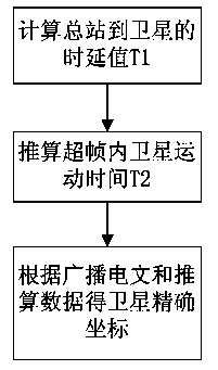
[0015] figure 1 It is a flow chart of an RNSS-based satellite positioning method of the present invention.

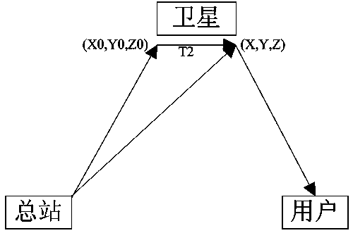
[0016] Such as figure 1 As shown, the present invention is realized by the following technical solutions: a method for accurately calculating the position of the Beidou No. 1 satellite, which includes three steps: S101, obtaining the time delay value that the nth subframe in a superframe is sent from the general station to the satellite T1; S102, according to the delay value T1, deduce the satellite movement time T2 during the nth subframe in a superframe from the general station to the ...


PUM


Abstract

The invention discloses a satellite positioning method based on an RNSS. The satellite positioning method comprises the steps that a time delay value T1 of sending the nth sub-frame in a superframe from a master station to a satellite is obtained; the motion time T2 of the satellite in the period when the nth sub-frame in the superframe is sent from the master station to the satellite is worked out according to the time delay value T1; according to the coordinate value of the satellite and the speed value of the satellite in a broadcast message and the motion time of the satellite, the accurate position coordinate of the satellite is obtained through calculation. By the adoption of the satellite positioning method, the problem that due to the fact that a large deviation already exists between the utilized satellite position in the broadcast message and the actual satellite position when positioning and time service calculation by the Compass-1 satellite system are conducted, the precision of a subscriber machine is influenced is solved. The satellite positioning method has the advantages that the positioning precision and the time service precision are improved. The invention further provides an information processing module and terminal.

Description

technical field [0001] The invention relates to the field of satellite navigation, in particular to an RNSS-based satellite positioning method, processing module and terminal. Background technique [0002] Satellite radio navigation system, the English full name is Radio Navigation Satellite System (abbreviated as RNSS), the user receives the satellite radio navigation signal, completes the distance measurement independently, and calculates the user's position, speed and navigation parameters. The "Beidou No. 1" satellite navigation system is a regional satellite navigation and positioning communication system developed and established by my country. The system uses synchronous orbit satellites for navigation and positioning. Positioning and navigation accuracy also puts forward higher requirements. The position of the geostationary satellite relative to the earth's ground is constant. The satellite itself is always in motion, so the position coordinate value of the satelli...

Claims


Application Information

Patent Timeline
IPC IPC(8): G01S19/42
CPCG01S19/42G04R20/02
Inventor 赵洲
Owner TECHTOTOP MICROELECTRONICS
Features
  • Generate Ideas
  • Intellectual Property
  • Life Sciences
  • Materials
  • Tech Scout
  • Unparalleled Data Quality
  • Higher Quality Content
  • 60% Fewer Hallucinations
Learn More