LiDAR point cloud filter method based on gradient and area growth

A technology of region growth and slope, applied in image data processing, instrumentation, calculation, etc., can solve problems such as inability to filter out, large amount of calculation, slow speed, etc., achieve small error, reduce calculation amount, and simple method

Inactive Publication Date: 2014-03-26
HOHAI UNIV
View PDF2 Cites 43 Cited by
  • Summary
  • Abstract
  • Description
  • Claims
  • Application Information

AI Technical Summary

Problems solved by technology

But this algorithm has some deficiencies: 1) For a point on a large-area object, such as a point on a large building, the greater the distance between it and the nearest ground point, the height difference threshold will vary with The distance increases and increases, that is, the conditions for rejecting it as a feature point are relaxed, which will make it impossible to filter out points on some large and relatively low ground features
2) The slope-based filtering algorithm judges the ground point by finding the adjacency relationship of the points and calculating the height difference between the two points point by point, which leads to a large amount of calculation and a slow speed of the algorithm

Method used


Image

  • LiDAR point cloud filter method based on gradient and area growth
  • LiDAR point cloud filter method based on gradient and area growth
  • LiDAR point cloud filter method based on gradient and area growth

Examples


Embodiment Construction

[0029] The technical solutions of the present invention will be described in detail below, but the protection scope of the present invention is not limited to the embodiments.

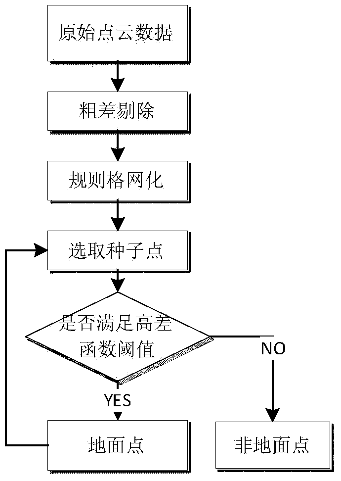
[0030] like figure 1 As shown, the LiDAR point cloud filtering method based on slope and region growth of the present invention is:

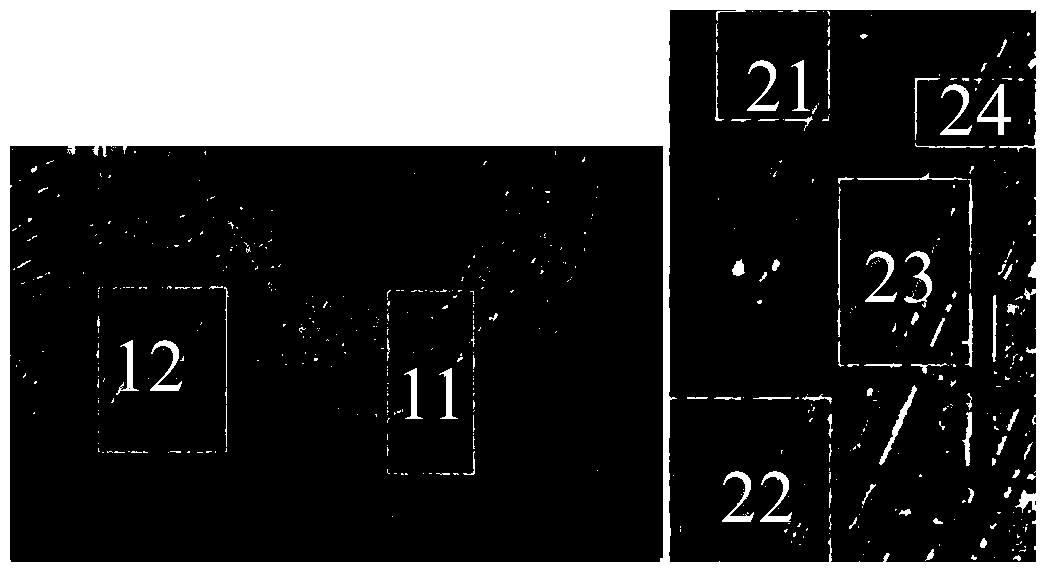
[0031] Step 1: Obtain the original LiDAR point cloud data; in order to test the stability and feasibility of the algorithm, the present invention uses the sample data provided by the International Society for Photogrammetry and Remote Sensing (ISPRS) for testing the filtering algorithm for testing. like figure 2 As shown in , six sample data of Site1 and Site2 data are selected for filtering experiments. The data point spacing is 1.0-1.5m, about 0.67 points are sampled per square meter, and the elevation error of the point cloud is basically between 0.2-0.3m. The experimental area is a typical urban area, with relatively gentle ground changes and complex features, in...


PUM


Abstract

The invention discloses a LiDAR point cloud filter method based on gradient and area growth. The method mainly includes the steps of firstly, acquiring the original LiDAR point cloud data; secondly, rejecting gross errors; thirdly, gridding rules; fourthly, selecting ground seed points; fifthly, performing area growth; sixthly, using the grids where the new ground points satisfying the conditions as centers and using the point, with the lowest elevation, in the grids as the new seed points for growing according to the fourth step until no points satisfy the conditions, and stopping growing; seventhly, sequentially performing area growth on seed points and centralized seed points according to the fourth step and the fifth step until the whole process is finished. By the method, the elevation threshold size is limited effectively, the calculation quantity of the whole method is lowered effectively, and the ground points and non-ground points in LiDAR point cloud data of complex cities can be separated fast. In addition, the method is simple, and the result obtained by the method is relatively small.

Description

technical field [0001] The invention belongs to the field of ground observation and relates to a LiDAR point cloud filtering method based on slope and region growth. Background technique [0002] Since the former US Vice President Al Gore put forward the concept of "Digital Earth" in 1998, it has aroused strong repercussions all over the world. The crystallization of the close integration of technology and social development and social science. As a part of the digital earth, the construction and application of digital cities has received more and more attention. The three-dimensional information of urban infrastructure has shown important application value in urban planning, municipal management, public safety and other aspects. Buildings are one of the most basic information in a digital city. The LIDAR system has the ability to directly describe the three-dimensional information on the surface of the survey area, and can quickly and efficiently collect the characteristic...

Claims


Application Information

Patent Timeline
Patent Type & Authority Applications(China)
IPC IPC(8): G06T5/00G06T7/00
Inventor 杨英宝于双李成仁刘会芬
Owner HOHAI UNIV
Why Eureka
Try Eureka