

An Incremental Ionospheric Refraction Error Correction Method
A refraction error and ionospheric technology, applied in the field of incremental ionospheric refraction error correction, can solve the problems of complex model parameters, low correction accuracy, and high cost of station deployment
Patent Information
- Authority / Receiving Office
- CN · China
- Patent Type
- Patents(China)
- Current Assignee / Owner
- Publication Date
- 2016-03-09
Smart Images
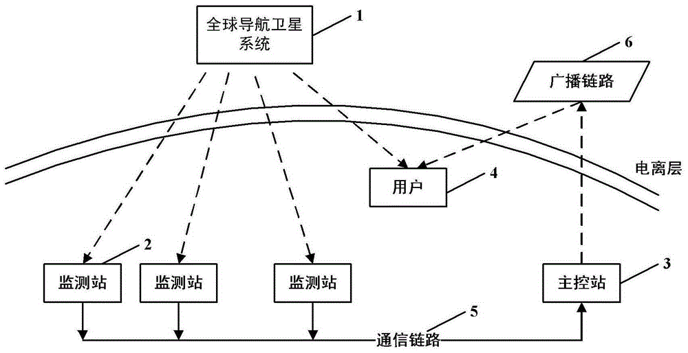
Figure 1 
Figure 2 
Figure 3
Abstract
Description
technical field
[0001] The invention relates to the field of ionospheric refraction error correction of satellite navigation systems, in particular to an incremental ionospheric refraction error correction method applied to GNSS single-frequency users. Background technique
[0002] As early as the mid-1990s, in order to break the monopoly position of the United States in the satellite positioning, navigation, and timing markets, the European Union has been committed to an ambitious civilian GNSS program, called the Global Navigation Satellite System (Global Navigation Satellite System, GNSS). The plan is implemented in two steps: the first step is to establish a first-generation global navigation satellite system (called GNSS-1 at the time, which was later built as EGNOS) that comprehensively utilizes the GPS system of the United States and the GLONASS system of Russia; It is to establish a second-generation global navigation satellite system completely independent of the G...
Examples
Embodiment Construction
[0085] In order to make the object, technical solution and advantages of the present invention clearer, the present invention will be described in further detail below in conjunction with specific embodiments and with reference to the accompanying drawings.
[0086] Such asfigure 1 as shown, figure 1 It is a structural schematic diagram of the system based on the incremental ionospheric refraction error correction method applied to GNSS single-frequency users provided by the present invention. The system is mainly composed of GNSS system 1, monitoring station 2, master control station 3, user 4, communication link 5 and broadcast link 6, among which:
[0087] (1) GNSS system: such as GPS system, COMPASS system, etc.;
[0088] (2) Monitoring station: It can also be called a reference station. Several monitoring stations are arranged in the service area of the system. It can also be used for broadcasting of the existing GNSS system by means of the reference station of the exi...