
Portable tablet type engineering geological surveying and mapping working method based on windows

An engineering geology, flat-panel technology, applied in the field of engineering geological survey, can solve the problems of complicated information, large amount of data, inability to call aerial photographs, satellite photographs, topographic maps, etc., to solve the problem of coordinates of actual geological points and save reciprocation Time and frequency, the effect of reducing office workload

Active Publication Date: 2015-03-11
长江三峡勘测研究院有限公司(武汉)
View PDF5 Cites 0 Cited by
  • Summary
  • Abstract
  • Description
  • Claims
  • Application Information

AI Technical Summary

Problems solved by technology

[0002] Engineering geological survey field geological work involves a variety of information, including written records, sketches, cataloged maps, geological photography, sampling, etc., with a large amount of data. In the traditional geological survey mode, geological data collection is mainly done by hand. , and all field data information is recorded in the form of paper media, which brings great difficulties to data management and data sharing, and to some extent restricts the full play of the benefits of data resources
Although there are currently field geological data acquisition systems based on laptops and 3G mobile phones, when working in the field, laptops are inconvenient to carry and record, and the battery life is short, while mobile phones have small screens and non-WINDOWS operating systems. Disadvantages such as inability to use a large number of aerial photos, satellite images, and topographic maps, and inability to use drawing software to draw geological maps on site

Method used


Image

  • Portable tablet type engineering geological surveying and mapping working method based on windows
  • Portable tablet type engineering geological surveying and mapping working method based on windows
  • Portable tablet type engineering geological surveying and mapping working method based on windows

Examples


Embodiment Construction

[0030] In order to make the object, technical solution and advantages of the present invention more clear, the present invention will be further described in detail below in conjunction with the examples. It should be understood that the specific embodiments described here are only used to explain the present invention, not to limit the present invention.

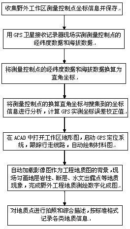
[0031] Such as figure 1 Shown, a kind of engineering geological surveying and mapping working method mainly comprises the following steps:

[0032] Step 1: Homework Preparation

[0033] 1. Preparation of equipment and installation: windows tablet computer; wireless Bluetooth GPS satellite receiving recorder; digital camera.

[0034] 2. Install working software and programs on a dedicated tablet computer;

[0035] 3. Collect the point numbers and coordinate information of the measurement control points in the work area, and save them as coordinate text files.

[0036] 4. Use the GPS satellite receiving recorder to measu...


PUM


Abstract

The invention relates to a portable tablet type engineering geological surveying and mapping working method based on windows. The engineering geological surveying and mapping working method comprises the following steps: collecting and storing coordinate information of a measurement control point of an outdoor working area; receiving longitude and latitude data and elevation data of the measurement control point, wherein the data are actually measured in site by a recorder through a GPS (Global Position System) satellite; converting the longitude and latitude data and the elevation data into rectangular coordinates; analyzing the converted rectangular coordinates of the measurement control point and the collected coordinate information, and carrying out error correction; opening a topographic map of the working area in an ACAD, starting a GPS, tracking a walking route, and automatically drawing a material draw; automatically loading a shadowgraph as a background of an engineering geological map; sketching geological phenomena in site, and completing digital mapping of outdoor engineering geological surveying and mapping; photographing and comprehensively describing a geological point, and recording various geological information according to a standard format. The method provided by the invention has the advantages of being simple and convenient to operate and accurate in positioning; the data are prevented from being repeatedly recorded; furthermore, the reciprocation time and frequency between a surveying and mapping site and a data center can be saved; all the work can be completed in an outdoor geological site; the working efficiency of the surveying and the mapping is high.

Description

technical field [0001] The invention belongs to the technical field of engineering geological surveying, and in particular relates to a working method for engineering geological surveying and mapping. Background technique [0002] Engineering geological survey field geological work involves a variety of information, including text records, sketches, cataloged maps, geological photography, sampling, etc., with a large amount of data. In the traditional geological survey mode, geological data collection is mainly done by hand. , and all field data information is recorded in the form of paper media, which brings great difficulties to data management and data sharing, and to some extent restricts the full play of the benefits of data resources. Although there are currently field geological data acquisition systems based on laptops and 3G mobile phones, when working in the field, laptops are inconvenient to carry and record, and the battery life is short. Mobile phones have ...

Claims


Application Information

Patent Timeline
Patent Type & Authority Patents(China)
IPC IPC(8): G01C11/00G06F17/50
CPCG01C11/00G01V8/02
Inventor 廖立兵陈又华段建肖潘金鹤刘彦杰肖鹏刘冲平张熊刘伟强孙青兰杨静张春芳
Owner 长江三峡勘测研究院有限公司(武汉)
Learn More