Quick detection method for airspace conflicts

A detection method and conflict detection technology, applied in special data processing applications, instruments, electrical digital data processing, etc., can solve problems such as inapplicability, achieve the effects of simplifying types and processes, reducing complexity, and reducing performance requirements

Active Publication Date: 2014-09-17
THE 28TH RES INST OF CHINA ELECTRONICS TECH GROUP CORP
View PDF7 Cites 18 Cited by
  • Summary
  • Abstract
  • Description
  • Claims
  • Application Information

AI Technical Summary

Problems solved by technology

In the existing research, the planar projection of the airspace is generally modeled as a polygon. In computational geometry and computer graphics, the intersection between points and polygons, lines and polygons, and arbitrary polygons has been studied in depth. The intersection between arbitrary polygons is mainly Using the tree structure of Weiler al

Method used


Image

  • Quick detection method for airspace conflicts
  • Quick detection method for airspace conflicts
  • Quick detection method for airspace conflicts

Examples


Embodiment

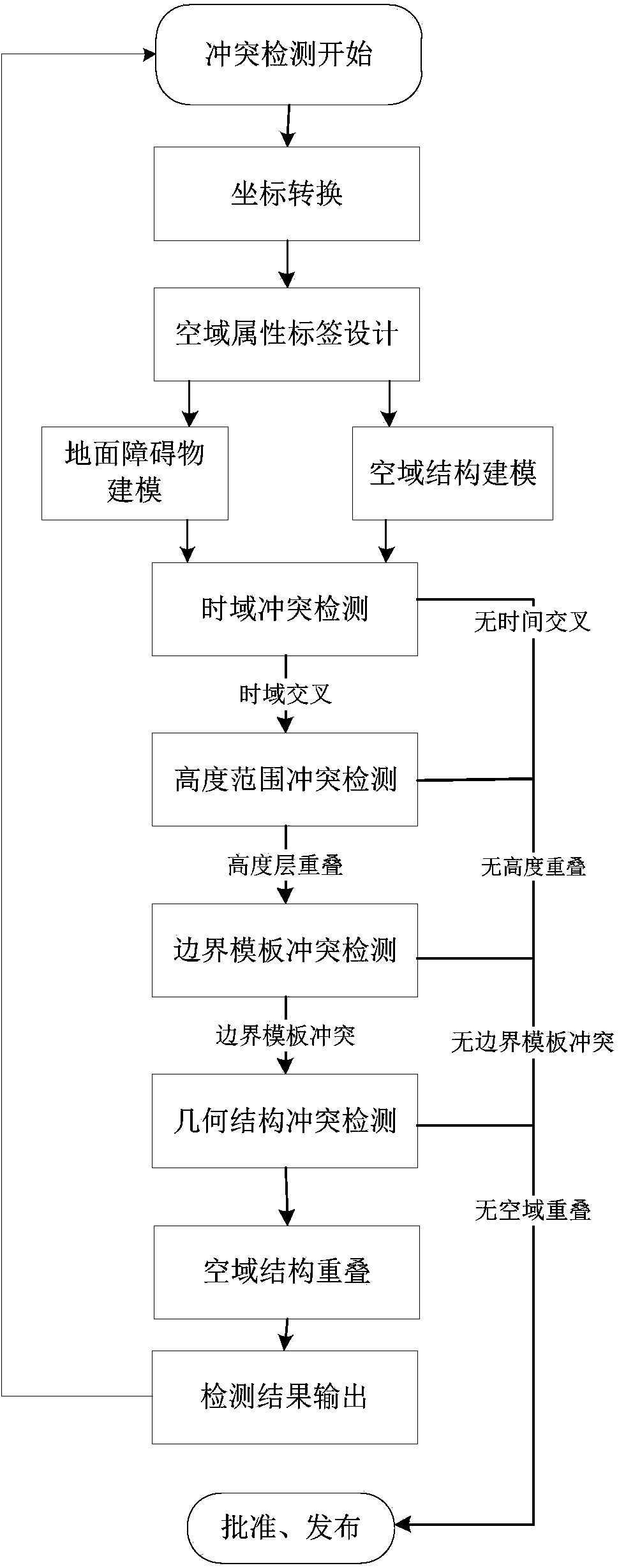
[0072] Airspace conflict detection adopts the method of "from coarse to fine, step by step elimination", and the computational complexity of the detection step is gradually increased. If the detection result of the previous step is no conflict, it will not participate in the next step of conflict detection, thus avoiding unnecessary complexity operation. Each step of airspace conflict detection does not require to be able to determine the conflicts that exist in the airspace, but it must be able to exclude non-existing conflict types, so that the airspace conflicts can be screened out through the "step by step elimination" method. Mainly includes terrain structure modeling and airspace conflict detection, combined with errors! Reference source not found. , the implementation process of the present invention is described in detail below:

[0073] 1. Coordinate transformation

[0074] Since the earth is an ellipsoid, the results of airspace planning are usually represented by...


PUM


Abstract

The invention discloses a quick detection method for airspace conflicts. The method comprises the first step of performing conversion from a WGS-84 coordinate system (B, L, H) to a rectangular plane coordinate system (X, Y, Z) on airspace planning boundary points to lower the complexity of airspace modeling, the second step of setting airspace attribute tags and planning airspace shapes comprising polygons, circles and sectors, the third step of performing border template modeling on planar projections of terrain and airspace, wherein the border template modeling comprises structural modeling on the terrain and property modeling on the airspace, and the fourth step of performing detection for airspace conflicts in twos by traversing the airspace to be detected. According to the detection method, the conflicts are gradually excluded in a coarse-to-fine mode. The conflict conditions between the airspace and the terrain and between the airspace and other airspace can be quickly determined. Besides, the quick detection method has the advantages of being good in model adaptability, small in calculation amount, high in operability and the like.

Description

technical field [0001] The invention relates to a method for detecting conflicts between airspace, terrain and airspace, and belongs to the field of airspace management in air traffic management. Background technique [0002] The traditional flight conflict detection in the field of military and civil aviation mainly takes the aircraft as the research object, and takes the route flight as the research scene. According to the existing flight plan and track prediction method, the distance and time between aircraft and multiple aircraft Conflict detection, to predict and warn when the relative position in the four-dimensional space (horizontal, lateral, vertical, time) does not meet the interval standard. It mainly includes the planning stage and the plan execution stage. The planning stage is based on the flight plan, through ground or airborne radar detection, using four-dimensional track prediction technology, and according to the estimated time, estimated speed and estimate...

Claims


Application Information

Patent Timeline
IPC IPC(8): G06F19/00
Inventor 冯程王犇李云茹徐琳满青珊贲伟
Owner THE 28TH RES INST OF CHINA ELECTRONICS TECH GROUP CORP
Why Eureka
Try Eureka