Urban three-dimensional space vector modeling method based on paper plane data

A plane data, three-dimensional space technology, applied in 3D modeling, image data processing, electrical digital data processing, etc., to save financial, human and material resources, reduce time costs, and improve utilization efficiency.

Active Publication Date: 2014-10-01
SOUTHEAST UNIV
View PDF4 Cites 16 Cited by
  • Summary
  • Abstract
  • Description
  • Claims
  • Application Information

AI Technical Summary

Problems solved by technology

But at present, the intelligent recognition of planning drawings cannot meet the current needs, and the recognition of architectural drawings has a long way to go

Method used


Image

  • Urban three-dimensional space vector modeling method based on paper plane data
  • Urban three-dimensional space vector modeling method based on paper plane data
  • Urban three-dimensional space vector modeling method based on paper plane data

Examples


Embodiment

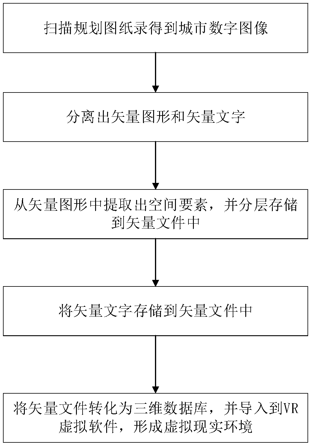
[0025] The urban three-dimensional space vector modeling method based on paper plane data of the present embodiment, such as figure 1 shown, including the following steps:

[0026] 1) Use scanning equipment to input the planning drawings of the city into the computer, and perform binarization processing to obtain a digital image of the city;

[0027] 1.1) Selection of scanning equipment: Since urban planning drawings are often large in size, large-format A0 scanners should be selected for instrument selection (if there is no large-format scanner, paper drawings can be folded and scanned, and finally scanned in Adobe Photoshop software) to input city planning drawings. A large-format scanner is a graphic scanning input device with a close-connected image sensing system as a sensor. It takes a city planning drawing like a photo through multiple image sensing systems, and converts it into a dot matrix by itself. into the computer.

[0028] 1.2) Use the scanning device to pre-i...


PUM


Abstract

The invention relates to an urban three-dimensional space vector modeling method based on paper plane data and aims at solving the problem that lots of existing surveying and mapping data of common second- and third-tier cities, and cities and towns and villages in central and western regions of China still rely on paper drawings and are difficult to manage, use and share; the method is based on a scanning device as a platform and on the basis of OCR (Optical Character Recognition) and ArcGis software, and comprises the steps of firstly, performing vectorizing recognition on the paper drawings, secondly, performing hierarchical processing on the entire vector drawings, and finally, inputting the vector drawings into a spatial database for spatial modeling, thereby forming a visual model in a three-dimensional form and also forming urban spatial form data which can be controlled by a town and country planning administrator, used by a town and country planning officer and cognized by ordinary citizens. The urban three-dimensional space vector modeling method based on paper plane data is quick and accurate due to the adopted simple, feasible and automatic steps; the paper drawings are converted into the digital form model to promote the utilization of the town and country planning achievements and the improvement of the technical measures under the novel urbanization background.

Description

technical field [0001] The invention relates to a method for modeling urban three-dimensional space vectors based on paper plane data, and belongs to the technical field of urban planning. Background technique [0002] In my country's planning management and surveying and mapping departments, paper drawings have been used to record and store urban spatial data for a long time. In the long-term and production process, people have accumulated a large number of paper engineering drawings. These drawings are the crystallization of people's experience and wisdom, and are an important basis and foundation for new product design and development. However, due to the large amount of drawings, it brings inconvenience to the preservation, management and use of drawings. With the development of information technology, computer-aided design (CAD) technology has been widely used in various fields of engineering design. The accuracy, intelligence and easy editing of CAD have significantly...

Claims


Application Information

Patent Timeline
Patent Type & Authority Applications(China)
IPC IPC(8): G06F17/50G06T17/05
Inventor 杨俊宴胡昕宇史宜
Owner SOUTHEAST UNIV
Why Eureka
Try Eureka