Feature-based airborne laser point cloud and image data fusion system and method

An image data, airborne laser technology, applied in image data processing, image enhancement, image analysis and other directions, to achieve the effect of shortening cycle, high efficiency and high precision

Inactive Publication Date: 2015-01-07
SOUTH CHINA UNIV OF TECH
View PDF3 Cites 74 Cited by
  • Summary
  • Abstract
  • Description
  • Claims
  • Application Information

AI Technical Summary

Problems solved by technology

[0004] At present, there are still some gaps in the fusion scheme of laser point cloud and CCD image data based on the low-altitude

Method used


Image

  • Feature-based airborne laser point cloud and image data fusion system and method
  • Feature-based airborne laser point cloud and image data fusion system and method
  • Feature-based airborne laser point cloud and image data fusion system and method

Examples


Embodiment Construction

[0049] The present invention will be further described in detail below in conjunction with the embodiments and the accompanying drawings, but the embodiments of the present invention are not limited thereto.

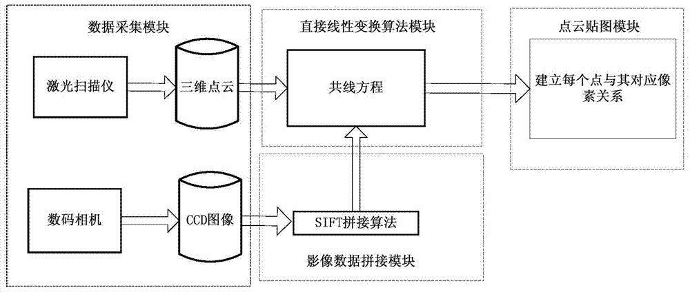
[0050] Such as figure 1 As shown, the feature-based airborne laser point cloud and image data fusion system provided by the present invention includes a point cloud and image data acquisition module, an image data splicing module, a direct linear transformation algorithm module and a point cloud sticker. Figure 4 a module; the point cloud and image data collection module is mainly to collect data respectively by the airborne laser scanner and the camera sensor; the image data stitching module is responsible for using the stitching algorithm to splice the collected camera photos to obtain a panoramic picture ; The direct linear transformation algorithm module is responsible for using the collinear equation in the photogrammetry theory to establish the transformation rela...


PUM


Abstract

The invention discloses a feature-based airborne laser point cloud and image data fusion method. The method sequentially comprises the steps of conducting SIFT image stitching on image data acquired by an airborne camera; determining feature points, corresponding to image data, in point cloud data in a scanning area; establishing the corresponding relationship between the line and row numbers of a three-dimensional point cloud and line and the row numbers of pixel points in a two-dimensional stitched image plane by means of the direct linear transformation method in the photogrammetry field; finally applying RGB color information of the pixel points to every point in the point cloud so that fusion of the two kinds of data can be realized. The feature-based airborne laser point cloud and image data fusion system and method are easy to realize, high in fusion effect and fusion accuracy, capable of well achieving point cloud mapping in a small unmanned helicopter laser scanning system, high in flexibility, and adaptable to the situation that a camera and a laser scanner acquire data separately.

Description

technical field [0001] The invention relates to the field of geographic three-dimensional space modeling, in particular to a feature-based airborne laser point cloud and image data fusion system and method. Background technique [0002] Airborne LiDAR (LIDAR) measurement technology is an emerging geospatial information acquisition technology. With the continuous improvement of the integration of hardware devices, many LIDAR systems have integrated CCD (image sensor) digital cameras, which can obtain image data of the scene under test while measuring and obtaining point cloud data. The spatial information and light intensity information of the target can be quickly obtained through the airborne laser scanner, which is helpful for establishing an accurate DTM model. Due to the limitation of the working mode of the laser scanner, the point cloud data has the characteristics of discreteness, uneven density, irregularity, etc., and it is impossible to directly obtain the surface...

Claims


Application Information

Patent Timeline
IPC IPC(8): G06T17/00G06T17/05
CPCG06T7/50G06T17/05G06T2207/10004G06T2207/10028G06T2207/20221G06T2207/30181
Inventor 裴海龙徐勇
Owner SOUTH CHINA UNIV OF TECH
Why Eureka
Try Eureka