Satellite orientation based azimuth calibration method and device

A satellite orientation and calibration device technology, which is applied to satellite radio beacon positioning systems, measuring devices, and directional devices for measuring directions, etc., can solve problems such as inability to achieve azimuth calibration and inability to complete azimuth calibration

Active Publication Date: 2015-04-08
湖南航天电子科技有限公司 +2
View PDF5 Cites 36 Cited by
  • Summary
  • Abstract
  • Description
  • Claims
  • Application Information

AI Technical Summary

Problems solved by technology

The disadvantage of this method is that it does not get rid of the traditional fixed station / mobile station differential mode, and can only operate within the coverage of the differential information broadcast by the fixed station, and cannot achieve position calibration anytime and anywhere; It is an instrument and equipment combined with GPS technology, which usually uses PPP technology to realize fast and high-precision positioning measurement without control points, and cannot complete the calibration of azimuth; the patent "Total Station and GPS Single-frequency Real-time Dynamic Combination Measurement Method and System" (Application No.: 200510110504.X) is essentially a single-frequency RTK system. The combination of GPS and total station is to use the angle and distance measurements provided by the total station to provide prior information for the single-frequency RTK solution. Transfer issues involving orientation

Method used


Image

  • Satellite orientation based azimuth calibration method and device
  • Satellite orientation based azimuth calibration method and device

Examples


Embodiment Construction

[0033] In order to make the purpose, technical solutions and advantages of the embodiments of the present invention clearer, the technical solutions in the embodiments of the present invention will be clearly and completely described below in conjunction with the drawings in the embodiments of the present invention. Obviously, the described embodiments It is a part of embodiments of the present invention, but not all embodiments. Based on the embodiments of the present invention, all other embodiments obtained by persons of ordinary skill in the art without making creative efforts belong to the protection scope of the present invention.

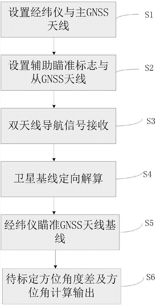
[0034] figure 1 It is a schematic flow chart of the satellite orientation-based azimuth calibration method provided by the present invention, including steps:

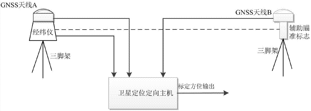
[0035] S1. Set up theodolite and main GNSS antenna

[0036] To set up the main GNSS antenna on the theodolite, it is required that the rotation center of the theodolite’s horizontal...


PUM


Abstract

The invention discloses a satellite orientation based azimuth calibration method and device. According to the method, true north azimuths of two satellite antenna represented base lines are calibrated according to a high-precision relative positioning principle based on carrier phase ambiguity-resolving; the azimuths of the base lines are derived with angle measuring instruments such as a theodolite or a total station; the true north information of each azimuth to be measured is measured. According to the satellite orientation based azimuth calibration method and device, high-precision satellite orientation is used as an azimuth reference, and the theodolite is used to derive the true north azimuth of the azimuth reference for azimuth calibration. The satellite orientation based azimuth calibration method and device has the advantages that the ways of using traditional fixing marker post and the like are replaced by the use of a movably erectable GNSS (global navigation satellite system) antenna, no satellite differential station is required, azimuth calibration flexibility is greatly improved, and the azimuth calibration range is greatly widened.

Description

technical field [0001] The invention relates to the technical field of directional measurement, in particular to an azimuth calibration method and device using satellite directional technology as an azimuth baseline. Background technique [0002] Accurate measurement of true north orientation is a basic problem in the fields of geodetic surveying, engineering surveying and mapping, and instrument calibration. A series of measuring instruments and supporting methods represented by gyro north finders, theodolites, total stations, etc. The station instrument can accurately measure the difference in azimuth, but cannot directly provide true north information. The gyro north finder can calibrate the true north position in seconds, but it is expensive and takes a long time to calibrate, usually 10 to 20 minutes. The derived gyro theodolite and gyro total station combine the true north calibration function of the gyro north finder with the angle difference measurement function of t...

Claims


Application Information

Patent Timeline
Patent Type & Authority Applications(China)
IPC IPC(8): G01S3/46G01S19/44G01C1/02
CPCG01C1/02G01S3/46G01S19/44
Inventor 陈晓峰罗丁肖茂森陆卫国刘建华朱宇虹翟玉涛蒙连胜
Owner 湖南航天电子科技有限公司
Why Eureka
Try Eureka