Navigation system based on multi-sensor data fusion

A technology of data fusion and navigation system, applied in the field of robot navigation, can solve the problems of incomplete, unpredictable and unreliable data, improve real-time and accuracy, and avoid redundancy and contradiction.

Inactive Publication Date: 2015-04-22
CHANGZHOU INST OF ADVANCED MFG TECH
View PDF7 Cites 25 Cited by
  • Summary
  • Abstract
  • Description
  • Claims
  • Application Information

AI Technical Summary

Problems solved by technology

During the navigation process, it is often faced with an environment that cannot be known in advance, is unpredictable or dynamically changes
The means

Method used


Image

  • Navigation system based on multi-sensor data fusion
  • Navigation system based on multi-sensor data fusion
  • Navigation system based on multi-sensor data fusion

Examples


Embodiment 1

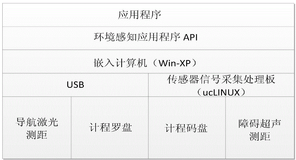
[0021] The hardware structure of the present invention is as figure 1 shown. Use the sensor signal acquisition and processing board to process the data collected by each sensor, and combine the environment perception application program API and the analysis and processing embedded in the computer to complete the navigation and positioning. The ultrasonic ranging sensor is used as the obstacle avoidance and obstacle walking measurement unit, and the laser scanning The sensor acts as a precise positioning and obstacle avoidance measurement unit.

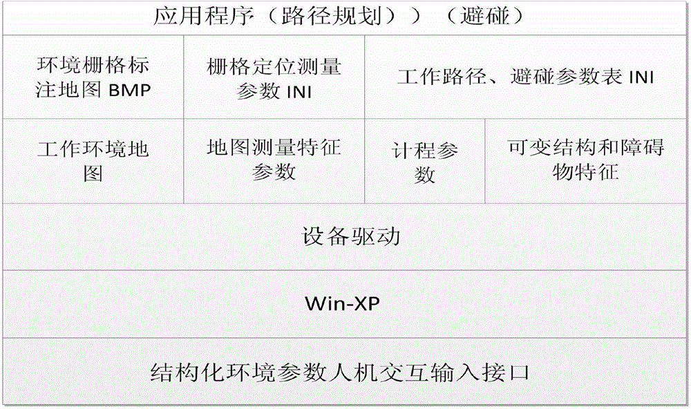
[0022] like figure 2 As shown in Fig. 1, combined with architectural drawings and surveyed work sites, the grid-marked map is artificially generated through the environmental modeling software module. Write the map editing software, input the architectural drawings into the computer, measure the architectural drawings and mark them on the grid map. Form a raster map containing information on the structure of the work environment (e...


PUM


Abstract

The invention discloses a navigation system based on multi-sensor data fusion. The navigation system comprises a map building module, a positioning module, a log module and a path planning module. The map building module manually generates a raster map through environment modeling software by measuring a work site in combination with an architectural drawing. The positioning module measures the relative position of a robot and the environment through a laser scanning sensor, works out the distance between the robot and a wall, obtains the world coordinates of the robot through conversion of coordinates and achieves the positioning function. The log module fuses log data and data measured by laser scanning to form navigation data flow. The data measured by the sensor are comprehensively analyzed through a fusion algorithm, and the navigation task is finished through map building, automatic positioning and path planning. The navigation system is provided with a relatively complete information obtaining channel, information redundancy and contradiction are effectively avoided through a unique information processing method, and real-time performance and accuracy are improved obviously.

Description

technical field [0001] The invention relates to the technical field of robot navigation, in particular to a navigation system based on multi-sensor data fusion. Background technique [0002] In recent years, with the advancement of technologies such as sensors, intelligent robot systems have begun to be applied in the service industry, opening up a new field of robot autonomous services. In the research of mobile robot navigation control theory and methods, the navigation control method of deterministic environment has achieved great success. A large number of research and application results. Some studies have been carried out on navigation control in unknown environments, and some methods have been proposed, but a unified and perfect system structure has not yet been formed, and many key theoretical and technical problems need to be solved and perfected. These problems include modeling of the environment, localization, learning and optimization of navigation controllers, ...

Claims


Application Information

Patent Timeline
IPC IPC(8): G01C21/00
CPCG01C21/32
Inventor 周旋孔令成赵江海
Owner CHANGZHOU INST OF ADVANCED MFG TECH
Why Eureka
Try Eureka