Wheat LAI (leaf area index) estimation method coupled with satellite-ground remote sensing

An area index, wheat leaf technology, applied in the field of agricultural vegetation remote sensing, can solve the problem of multiple pixels in growth remote sensing monitoring, and achieve the effect of promoting wide application, high precision and accuracy, and realizing real-time acquisition.

Inactive Publication Date: 2015-04-29
INST OF AGRI ECONOMICS & INFORMATION HENAN ACADEMY OF AGRI SCI
View PDF5 Cites 15 Cited by
  • Summary
  • Abstract
  • Description
  • Claims
  • Application Information

AI Technical Summary

Problems solved by technology

[0005] The purpose of the present invention is to overcome the deficiencies in the prior art and provide a method for estimating wheat leaf area index coupled with satellite-earth remote sensing, which is used to solve the problem of more mixed pixels in spatial scale crop growth remote sensing monitoring

Method used


Image

  • Wheat LAI (leaf area index) estimation method coupled with satellite-ground remote sensing
  • Wheat LAI (leaf area index) estimation method coupled with satellite-ground remote sensing
  • Wheat LAI (leaf area index) estimation method coupled with satellite-ground remote sensing

Examples


Embodiment Construction

[0023] The present invention will be further described below in conjunction with specific embodiments.

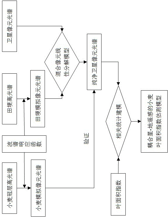
[0024] A method for estimating wheat leaf area index coupled with satellite-terrestrial remote sensing, the details are as follows:

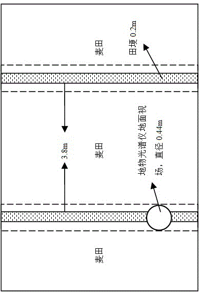
[0025] 1) Obtain canopy spectral information at two different scales from wheat ground hyperspectral and SPOT-5 images;

[0026] 2) Using the satellite sensor spectral response function to fit the wheat canopy hyperspectrum and field ridge hyperspectrum;

[0027] 3) Realize the extraction of pure satellite pixel spectrum based on the mixed pixel linear decomposition model;

[0028] 4) At the same time, the pure satellite pixel spectrum is verified by using the synchronized wheat simulation pixel spectrum;

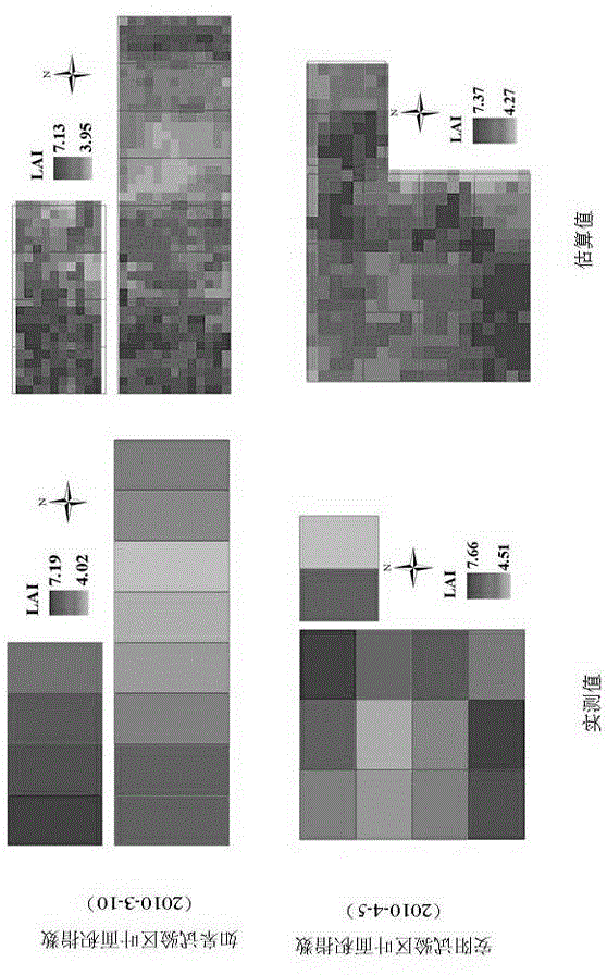
[0029] 5) Using correlation statistical methods to build a monitoring model of wheat leaf area index coupled with satellite-earth remote sensing.

[0030] Based on the above, the specific algorithm of the spectral response function used...


PUM


Abstract

The invention relates to the field of agricultural vegetation remote sensing, particularly to a wheat LAI (leaf area index) estimation method coupled with satellite-ground remote sensing. The method comprises steps as follows: 1) acquiring two different scales of canopy spectrum information, namely, a wheat ground high-spectrum and an SPOT-5 image; 2) fitting a wheat canopy high-spectrum and a ridge high-spectrum with a satellite sensor wave spectrum response function; 3) extracting a pure satellite pixel spectrum on the basis of a mixed pixel linear decomposition model; 4) meanwhile, verifying the pure satellite pixel spectrum by the aid of a synchronous wheat simulation pixel spectrum; 5) constructing a wheat LAI monitoring model coupled with satellite-ground remote sensing with related statistical methods. The method overcomes defects of existing ground remote sensing point scales and satellite remote sensing mixed pixels and is higher in precision and accuracy of estimation of wheat LALs at different nitrogen application levels in different ecological regions in particular, wheat LAI growth information is acquired in real time, and wide application of remote sensing based crop growth remote sensing monitoring technologies is facilitated.

Description

technical field [0001] The invention relates to the field of agricultural vegetation remote sensing, in particular to a method for estimating wheat leaf area index coupled with satellite-terrestrial remote sensing. Background technique [0002] Leaf Area Index (LAI) refers to the ratio of the sum of the single-sided area of ​​all leaves of a plant to the land area occupied by the plant, which can reflect the potential leaf area of ​​plants that can be used for light energy interception and gas exchange. It is a description of crops in remote sensing monitoring. The most commonly used parameter of growth condition and an important parameter for crop yield assessment. As an important parameter in agronomy, ecology and meteorology, leaf area index is widely used in plant growth models, energy balance models, climate models and canopy reflection models. [0003] The traditional method of obtaining crop leaf area index mainly relies on destructive sampling and indoor analysi...

Claims


Application Information

Patent Timeline
Patent Type & Authority Applications(China)
IPC IPC(8): G01B11/28
Inventor 王来刚程永政刘婷郑国清郭燕李冰
Owner INST OF AGRI ECONOMICS & INFORMATION HENAN ACADEMY OF AGRI SCI
Why Eureka
Try Eureka