Direct assimilation method of MODIS satellite data

A satellite data and direct technology, applied in the field of assimilation, can solve problems such as unsatisfactory wind power forecasting and forecasting, and achieve the effects of improving accuracy, enhancing simulation, and improving accuracy

Inactive Publication Date: 2015-05-20
STATE GRID CORP OF CHINA +2
View PDF0 Cites 20 Cited by
  • Summary
  • Abstract
  • Description
  • Claims
  • Application Information

AI Technical Summary

Problems solved by technology

However, the numerical weather prediction data currently used for wind power prediction are usually obtained through dynamic downscaling of mesoscale numerical weather prediction models, and very few assimilate limited conventional meteorological observation data. Forecast requirements
However, considering the differences between my country's major wind power development zones and the distribution of conventional meteorological stations, it is urgent to develop satellite observation data assimilation. Satellite observation data has the characteristics of consistent data, wide coverage, and high temporal and spatial resolution. An Effective Means of Power Forecasting and Unsatisfactory Forecasting Effect

Method used


Image

  • Direct assimilation method of MODIS satellite data
  • Direct assimilation method of MODIS satellite data
  • Direct assimilation method of MODIS satellite data

Examples


Embodiment Construction

[0047] The present invention will be further described below in conjunction with the accompanying drawings.

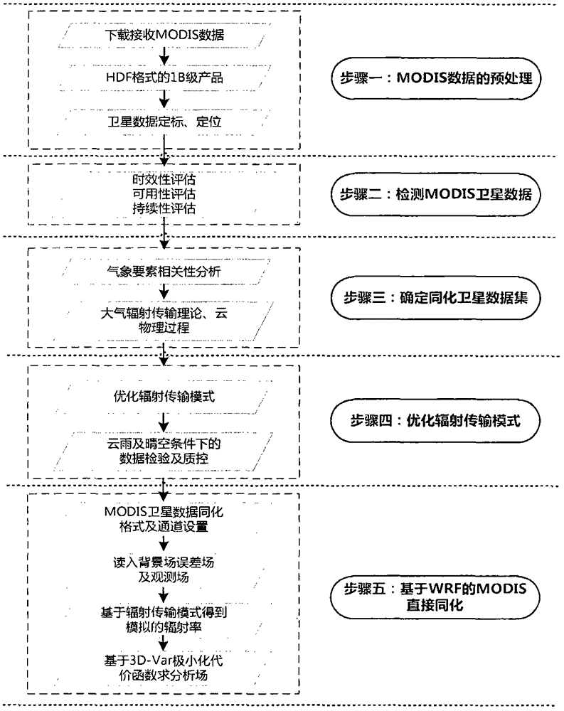
[0048] Such as figure 1 As shown, a direct assimilation method of MODIS satellite data, wherein the MODIS satellite data is: Moderate-resolution Imaging Spectroradiometer MODIS (Moderate-resolution Imaging SpectroRadiometer) is carried on the earth observation satellite EOS (Earth Observing Satellites) TERRA and AQUA The current new generation of "map-integration" optical remote sensing instrument. The EOS program is a global change research program initiated by NASA (National Aeronautics and Space Administration). It is a long-term observation system based on the sun-synchronous orbit. The observation capability will last for 30 years and will be gradually developed and strengthened. .

[0049] MODIS consists of a transverse scanning mirror, a collection device, a linear detector array and spectral interference filters located on four focal planes. MODIS is designe...


PUM


Abstract

The invention provides a direct assimilation method of MODIS satellite data. The direct assimilation method of the MODIS satellite data includes the steps that the MODIS satellite data are pre-processed; the MODIS satellite data are detected; an assimilation satellite data set is determined; a radiation transmission mode is optimized; the MODIS satellite data are assimilated. Simulation of the radiation transmission mode on the earth surface radiation process is improved, the accuracy of simulating the atmosphere movement inside a boundary layer by a numerical mode is improved, and the accuracy of numerical weather prediction data for wind power forecast is further improved.

Description

technical field [0001] The invention relates to an assimilation method, in particular to a direct assimilation method of MODIS satellite data. Background technique [0002] An artificial earth satellite that conducts meteorological observations of the earth and its atmosphere from space is called a meteorological satellite. According to their different orbits, they can be divided into sun synchronous (polar orbit) satellites and geosynchronous (stationary) satellites. Meteorological satellites are equipped with various meteorological remote sensing instruments to receive and measure the visible light, infrared and microwave radiation of the earth and its atmosphere, and convert them into electrical signals and transmit them to ground stations. The ground station restores the electrical signal from the satellite, draws pictures of various clouds, land surface and sea surface, and then obtains various meteorological data after further processing and calculation. Meteorologic...

Claims


Application Information

Patent Timeline
Patent Type & Authority Applications(China)
IPC IPC(8): G06F19/00
Inventor 靳双龙冯双磊王勃刘纯王伟胜胡菊马振强宋宗朋姜文玲赵艳青王铮杨红英车建峰卢静张菲
Owner STATE GRID CORP OF CHINA
Why Eureka
Try Eureka