Vector tracking-based GNSS/SINS deep integrated navigation method

A deep integrated navigation and vector tracking technology, which is applied in the field of GNSS/SINS deep integrated navigation based on vector tracking, can solve the problems of signal loss of lock, susceptibility to electromagnetic interference, etc., and achieve the effect of improving performance and reducing processing burden

Inactive Publication Date: 2015-09-23
NANJING UNIV OF SCI & TECH
View PDF3 Cites 26 Cited by
  • Summary
  • Abstract
  • Description
  • Claims
  • Application Information

AI Technical Summary

Problems solved by technology

However, the traditional receiver tracking loop adopts scalar tracking mode, which is prone to signal loss of lock in a high dynamic environment and is susceptible to electromagnetic interference in a weak signal environment; while the centralized deep combination uses a vector tracking algorithm, but Due to the highly nonlinear relationship between the observed quantity and the state quantity in the model, it is difficult to put it into engineering practice

Method used


Image

  • Vector tracking-based GNSS/SINS deep integrated navigation method
  • Vector tracking-based GNSS/SINS deep integrated navigation method
  • Vector tracking-based GNSS/SINS deep integrated navigation method

Examples


Embodiment 1

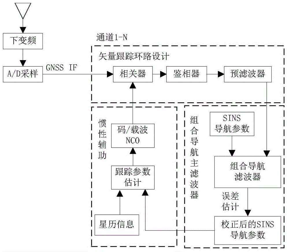
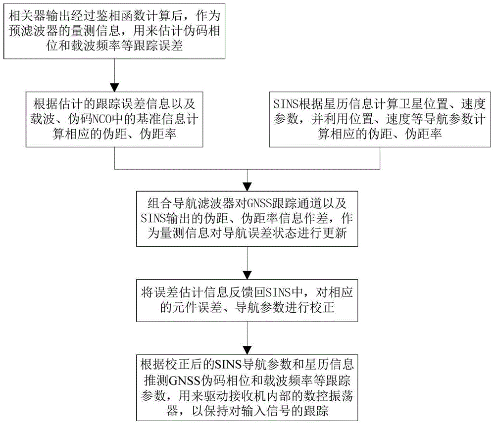
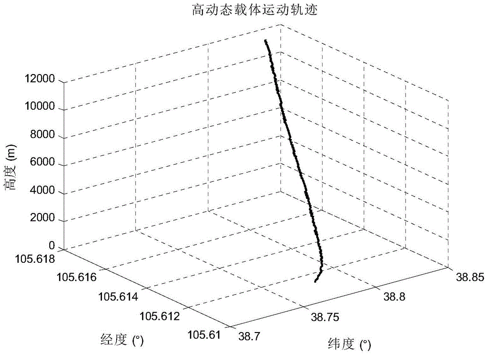
[0084] In order to illustrate the algorithm of the present invention, fully demonstrate that this algorithm has the performance that improves GNSS signal tracking and the adaptability of the satellite receiver to the high dynamic motion carrier, complete the high dynamic experiment as follows:

[0085] (1) Experimental initial conditions and parameter settings

[0086] The satellite navigation signal simulator is used to simulate satellite signals; the digital intermediate frequency signal is collected through the intermediate frequency signal collector, the sampling rate is 16.369MHz, and the intermediate frequency is 3.996MHz; the GNSS software receiver adopts two modes of scalar tracking and vector tracking respectively for carrier tracking. The road integration time is 1ms.

[0087] The simulated high dynamic trajectory is set as follows: starting point: 38.7580° north latitude, 105.6100° east longitude, 1431.90m elevation; end point: 38.8370° north latitude, 105.6195° eas...


PUM


Abstract

The invention discloses a vector tracking-based GNSS / SINS deep integrated navigation method. The method includes the following steps that: after in-phase orthogonal signals outputted by a correlator are calculated by a phase discrimination function, an obtained phase discrimination result is adopted as measurement information of a pre-filter, so that a pre-filter model can be constructed to estimate tracking error information, and therefore, the pseudo-range and pseudo-range rate of a GNSS tracking channel can be obtained; an integrated navigation main filter performs processing according to the pseudo-ranges and pseudo-range rates outputted by the GNSS tracking channel and an SINS, so that pseudo-range deviation and range rate deviation can be obtained and are adopted as measurement variables quantity, and the measurement quantity is used for updating navigation error state variables, and updated navigation error parameters are fed back to the SINS, so that the navigation parameters of the SINS can be calibrated; and an integrated navigation system infers the signal tracking parameters of a GNSS according to the calibrated SINS navigation parameters and ephemeris information so as to control the local pseudo codes of a receiver and a carrier digital-controlled oscillator, and therefore, tracking for input signals can be maintained. The method of the invention has excellent anti-jamming performance and dynamic tracking ability, and has a bright application prospect.

Description

technical field [0001] The invention relates to the field of satellite navigation and integrated navigation, in particular to a GNSS / SINS deep integrated navigation method based on vector tracking. Background technique [0002] The GNSS system has the advantages of all-weather and all-time, but it is susceptible to electromagnetic interference, and star loss and lock-up may occur under high dynamics; the SINS system is an autonomous navigation system that does not rely on any external information and does not radiate energy , has the advantages of small size, high data update rate, high short-term accuracy and not limited by weather conditions, but the navigation accuracy decreases with time. Therefore, the two are often combined to form a SINS / GNSS integrated navigation system. With the continuous improvement of the carrier's demand for the comprehensive performance of the navigation system, the research on GNSS / SINS integrated navigation technology has shifted from simple...

Claims


Application Information

Patent Timeline
Patent Type & Authority Applications(China)
IPC IPC(8): G01S19/49G01C21/16
CPCG01S19/49G01C21/165
Inventor 陈帅丁翠玲刘亚玲董亮余威蒋长辉屈新芬黄思亮彭蜀君
Owner NANJING UNIV OF SCI & TECH
Why Eureka
Try Eureka