Method of performing coastal wetland drawing for medium-resolution remote sensing image by utilizing object-oriented classification technology

A classification technology, object-oriented technology, applied in the field of coastal wetland mapping, which can solve the problems of enclave phenomenon and inability to accurately distinguish various wetland types.

Active Publication Date: 2016-03-30
NORTHEAST INST OF GEOGRAPHY & AGRIECOLOGY C A S
View PDF6 Cites 14 Cited by
  • Summary
  • Abstract
  • Description
  • Claims
  • Application Information

AI Technical Summary

Problems solved by technology

[0005] The present invention aims to solve the problem that traditional remote sensing image classification methods cannot accurately distinguish various wetland categories, and the classification results usually have "salt and pepper phenomenon" and "enclave phenomenon", which is not suitable for coastal wetland mapping of medium-resolution remote sensing images, and provides A Method for Coastal Wetland Mapping Using Object-Oriented Classification Techniques Based on Moderate Resolution Remote Sensing Images

Method used


Image

  • Method of performing coastal wetland drawing for medium-resolution remote sensing image by utilizing object-oriented classification technology
  • Method of performing coastal wetland drawing for medium-resolution remote sensing image by utilizing object-oriented classification technology
  • Method of performing coastal wetland drawing for medium-resolution remote sensing image by utilizing object-oriented classification technology

Examples


specific Embodiment approach 1

[0027] Specific Embodiment 1: A method of using object-oriented classification technology in this embodiment to carry out coastal wetland mapping on medium-resolution remote sensing images is implemented in the following steps:

[0028] Step 1: Download the Landsat8OLI image and the digital elevation model (DEM data), and perform preprocessing respectively, and predict the preprocessed Landsat8OLI image to determine the typical features of the coastal wetland;

[0029] Among them, the Landsat8OLI image preprocessing includes orthorectification and geometric fine correction; DEM preprocessing includes projection transformation to make the DEM consistent with the Landsat8OLI image coordinate system, and uses the Fill tool in ArcGIS to perform the processing of filling and cutting peaks.

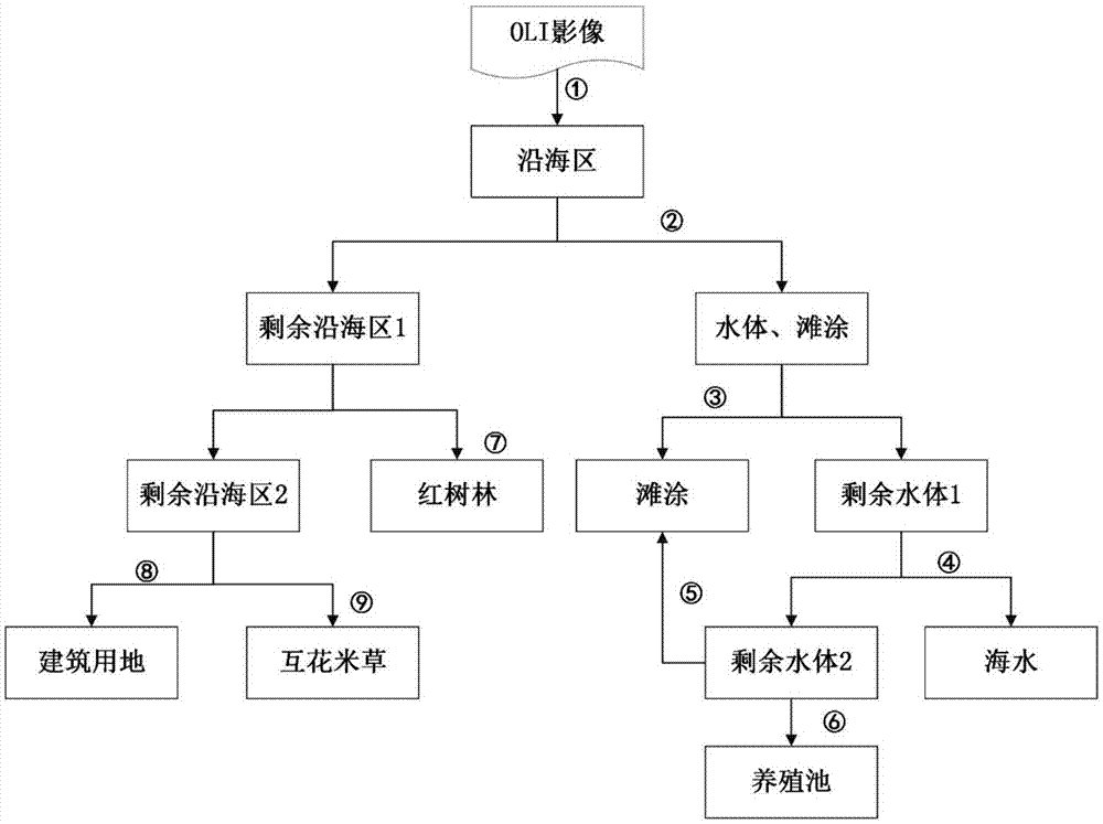
[0030] Step 2: Carry out multi-scale segmentation on the Landsat8OLI image preprocessed in Step 1, merge adjacent pixels into objects according to the homogeneity standard, and obtain the image ...

specific Embodiment approach 2

[0038]Specific embodiment two: the difference between this embodiment and specific embodiment one is: in step four, it is determined that the characteristics that can be used to distinguish typical features of coastal wetlands are calculated based on eCognitionDeveloper8.64 software: according to the normalized difference vegetation index (NDVI), surface Humidity Index (LSWI), Soil Brightness Index (SBI), and Normalized Difference Water Index (NDWI) formulas, use the CreateArithmeticFeature tool in Objectfeatures to calculate the above arithmetic features of the object respectively; obtain the hue (Hue) feature after band combination through HIS transformation; Use the preprocessed DEM in step 1 as the feature layer, and use the LayerValues ​​tool to calculate the DEM features of the image object.

[0039] Other steps and parameters are the same as those in Embodiment 1.

specific Embodiment approach 3

[0040] Specific implementation mode three: the difference between this implementation mode and specific implementation modes one or two is that the step five is specifically:

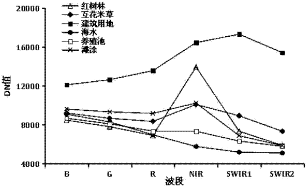
[0041] (1) In the image object layer obtained in step 2, using the calculation result of step 4, the object whose DEM is less than or equal to 10 and whose NDWI is between -0.08 and 0.32 is the area where the coastal wetland is located, named "coastal area";

[0042] (2) In the coastal area, the objects satisfying Hue (R='NIR', G='SWIR1', B='SWIR2') characteristics between 0.7 and 1 and NDVI less than 0.15 are water bodies and tidal flats, which do not meet The object of the condition is named "Remaining Coastal Zone 1";

[0043] (3) Among the water bodies and tidal flats, the objects satisfying that the LSWI is between 0.12 and 0.31 and the NDVI is greater than 0 are tidal flats, and the objects that do not meet the conditions are named "remaining water body 1";

[0044] (4) In the remaining water bod...


PUM


Abstract

The invention discloses a method of performing coastal wetland drawing for a medium-resolution remote sensing image by utilizing an object-oriented classification technology and relates to the method of performing coastal wetland drawing for the medium-resolution remote sensing image. The provided method is mainly to solve the problems that the various types of the wetlands cannot be distinguished exactly by a traditional remote sensing image classification method, the classified results generally have a spiced salt phenomenon and an enclave phenomenon, and the traditional remote sensing image classification method is not applicable for the coastal wetland drawing of the medium-resolution remote sensing image. The method of performing coastal wetland drawing for the medium-resolution remote sensing image by utilizing the object-oriented classification technology comprises the steps of performing pre-treatment for an Landsat8 OLI image and DEM data; performing multi-resolution segmentation for the Landsat8 OLT image after subjected to pre-treatment in the step 1; exporting to generate a coastal wetland typical ground object spectral curve; determining typical ground object characteristics which can be used for distinguishing the coastal wetlands; obtaining a preliminary classification result; optimizing the classification result; and exporting the classification result, that is, the coastal wetland typical ground object, and generating each coastal wetland type vector. The method of performing coastal wetland drawing for the medium-resolution remote sensing image by utilizing the object-oriented classification technology is used in the field of coastal wetland drawing.

Description

technical field [0001] The invention relates to a method for performing coastal wetland mapping on medium-resolution remote sensing images. Background technique [0002] Coastal wetlands are located in the interlaced transition zone between land and marine ecosystems. They are ecological types with both sea and land characteristics, and have special hydrology, vegetation, and soil characteristics. They play an important role in maintaining biodiversity, storing carbon, regulating climate, and controlling pollution. important role. In recent years, with the continuous impact of climate change and human activities, the natural environment and ecological landscape in coastal areas have changed significantly. Therefore, it is of great significance to quickly and accurately obtain the landscape pattern information of coastal wetlands for the management of wetland resources, the development and utilization of coastal areas and the sustainable development of resources. However, t...

Claims


Application Information

Patent Timeline
Patent Type & Authority Applications(China)
IPC IPC(8): G06F17/50
CPCG06F30/18
Inventor 刘明月王宗明满卫东贾明明毛德华路春燕任春颖
Owner NORTHEAST INST OF GEOGRAPHY & AGRIECOLOGY C A S
Why Eureka
Try Eureka