Spaceborne gnss joint orbit determination method and device

An orbit determination and satellite technology, applied in the field of satellite orbit determination, can solve the problems of single system orbit determination failure, affecting the on-orbit mission of the aircraft, etc., and achieve the effects of improving system completeness, increasing the number of available navigation satellites, and improving geometric configuration.

Inactive Publication Date: 2016-10-05
SPACE STAR TECH CO LTD
View PDF3 Cites 0 Cited by
  • Summary
  • Abstract
  • Description
  • Claims
  • Application Information

AI Technical Summary

Problems solved by technology

At the same time, under special circumstances, if a single navigation system fails, it will directly lead to the failure of single system orbit determination, affecting the mission of the aircraft in orbit.

Method used


Image

  • Spaceborne gnss joint orbit determination method and device
  • Spaceborne gnss joint orbit determination method and device
  • Spaceborne gnss joint orbit determination method and device

Examples


example 1

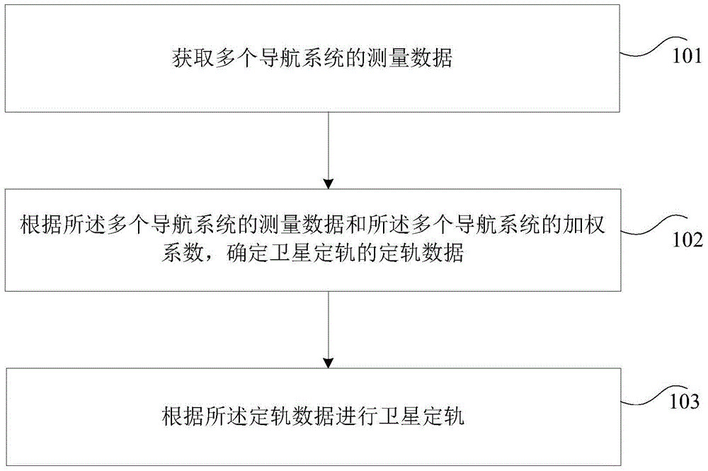
[0039] In this example, in order to overcome the shortcomings of orbit determination technology based on a single navigation system, a satellite orbit determination method is provided, which outputs higher-precision orbit information through weighted fusion of system observation data.

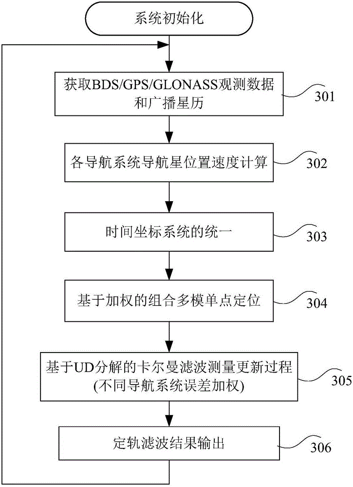
[0040] image 3It is a flow chart of the method for satellite orbit determination according to Example 1 of the embodiment of the present invention, such as image 3 As shown, the method includes the following steps:

[0041] Step 301, acquiring observation data and broadcast ephemeris of each navigation system (BDS / GPS / GLONASS).

[0042] Step 302, calculate the position, speed, etc. of each navigation system navigation star.

[0043] Step 303, unify the time and coordinate systems of each navigation system.

[0044] Step 304, performing weight-based combined multi-mode single-point positioning.

[0045] Step 305, update the Kalman filter measurement based on UD decomposition.

[0046] Ste...

example 2

[0052] In this example, it mainly includes the following processes:

[0053] 1. After the system initialization is completed, the time accumulation and multi-system time synchronization are completed by maintaining the local time based on the GPS time system.

[0054] Time system initialization: After the system captures and tracks the navigation star of a certain navigation system for the first time, it converts the time system of the navigation system into GPS time to complete the initialization of the local time.

[0055] After receiving the ephemeris data of each navigation system, the local time is converted to the time system of the corresponding navigation system, and the calculation of position and velocity information at different navigation star observation times is completed. After the calculation is completed, the unification of the position and velocity coordinate systems of each navigation star is completed, and at the same time, each time system is transferred b...


PUM


Abstract

The invention discloses a method and apparatus for satellite orbit determination. The method for satellite orbit determination comprises the steps of obtaining measurement data of a plurality of navigation systems; determining orbit determination data of the satellite orbit determination according to the measurement data of the plurality of navigation systems and weighting coefficients of the plurality of navigation systems; and performing satellite orbit determination according to the orbit determination data. Through the invention, combined orbit determination is conducted by introducing navigation star observation data of different navigation systems, the system completeness of a navigation receiver is improved, the number of available navigation satellites can be substantially increased, and the distribution geometry of the navigation satellites is improved.

Description

technical field [0001] The invention relates to the field of satellite orbit determination, in particular to a method and device for satellite orbit determination. Background technique [0002] The development of aerospace technology has gradually deepened and refined human exploration of space, and the determination of satellite autonomous orbits has become a hot spot for aerospace workers. [0003] With the rapid development of satellite application technology, all kinds of satellites play an increasingly important role in scientific practice, and future space missions put forward higher requirements for real-time high-precision satellite orbit determination. Satellite in-orbit missions sometimes require frequent satellite attitude maneuvers. During the attitude maneuver process, the signal tracking of a certain navigation system may lose lock, resulting in a reduction in the number of available navigation stars. At the same time, in the high-orbit environment, there are ...

Claims


Application Information

Patent Timeline
Patent Type & Authority Patents(China)
IPC IPC(8): G01S19/28G01S19/27
Inventor 王杰徐其超王猛李常亮刘迎娜王甫红赵文亮刘宪阳
Owner SPACE STAR TECH CO LTD
Why Eureka
Try Eureka