Self-localization method and system for mobile device in underground coal mine

A mobile device and autonomous positioning technology, which is applied in the direction of navigation, navigation, and instruments through speed/acceleration measurement, and can solve problems such as reduced reliability, low positioning accuracy, and complex structures.

Inactive Publication Date: 2016-05-04
HUAZHONG UNIV OF SCI & TECH
View PDF5 Cites 44 Cited by
  • Summary
  • Abstract
  • Description
  • Claims
  • Application Information

AI Technical Summary

Problems solved by technology

In practical applications, the density of the reference node layout and the site environment determine the positioning accuracy. The system has disadvantages such as low positioning accuracy, poor stability, and complex structure.
Inertial device navigation has the advantages of high real-time and little influence from the external environment. However, the inertial device itself has measurement noise, and the error accumulation of the inertial navigation system (Inertial Navigation System, INS) makes it unable to meet the long-term navigation and positioning requirements in the mine.
In the case of extremely low visibility in coal mines without additional light sources, the reliability of visual navigation and positioning will drop sharply due to the influence of light sources and the unobvious scene characteristics of coal mines.

Method used


Image

  • Self-localization method and system for mobile device in underground coal mine
  • Self-localization method and system for mobile device in underground coal mine
  • Self-localization method and system for mobile device in underground coal mine

Examples


Embodiment Construction

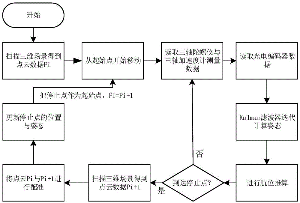
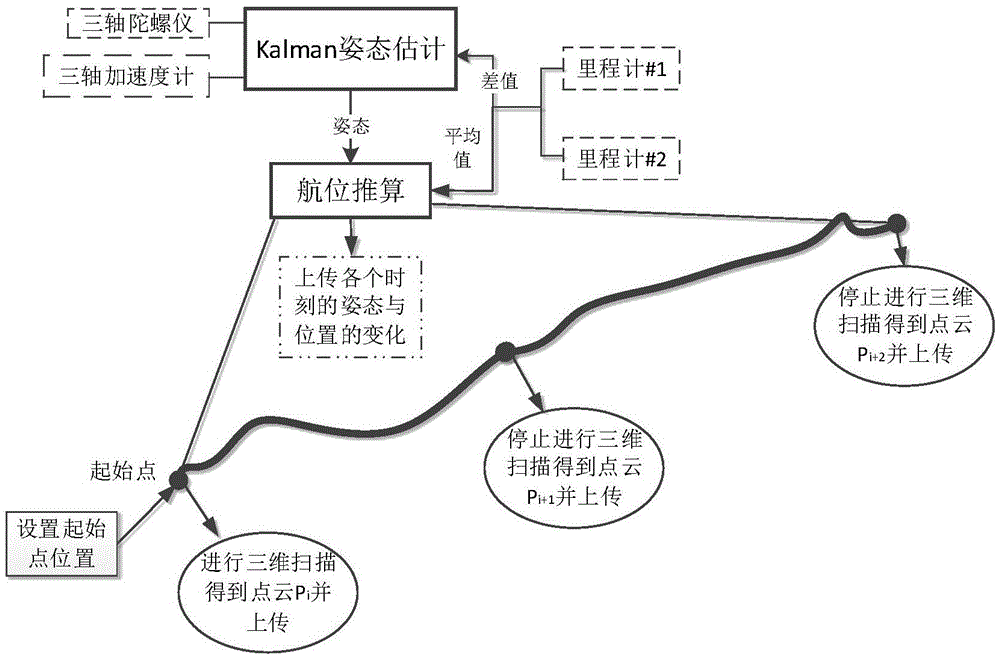
[0040] In order to make the object, technical solution and advantages of the present invention clearer, the present invention will be further described in detail below in conjunction with the accompanying drawings and embodiments. It should be understood that the specific embodiments described here are only used to explain the present invention, not to limit the present invention. In addition, the technical features involved in the various embodiments of the present invention described below can be combined with each other as long as they do not constitute a conflict with each other.

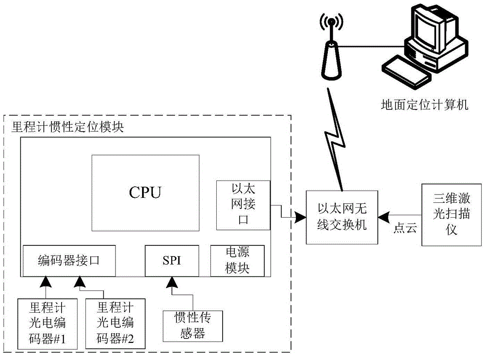
[0041] figure 1 It is a schematic diagram of the hardware structure of the autonomous positioning system for underground mobile equipment in coal mines according to the present invention. optional, in figure 1 In the illustrated embodiment, the photoelectric encoder is the odometer sensor. Such as figure 1 As shown, the system mainly includes an odometer inertial positioning module, an Ether...


PUM


Abstract

The invention discloses a self-localization method for a mobile device in an underground coal mine. The method comprises: performing scanning at a start point through a three-dimensional laser scanner to obtain three-dimensional point cloud data P; making the mobile device start moving, and performing dead reckoning through integration of data measured by an inertial transducer and a mileometer transducer to obtain a real-time position of the device; making the mobile device stop moving at a point not far from the start point, and performing scanning at the stop point to obtain three-dimensional point cloud data P<i+1>; registering P and P<i+1> to obtain displacement and attitude variation between the two points, and updating the position of the stop point; and taking the stop point as a new start point, and repeating the above steps to complete a whole real-time localization process. Accordingly, the invention further provides a localization system corresponding to the method. The system has low environment requirements; high-precision localization can be realized in a severe environment in an underground coal mine; and a three-dimensional visualization module of the whole environment is established.

Description

technical field [0001] The invention belongs to the technical field of positioning, and in particular relates to a method and system for autonomous positioning of underground mobile equipment in coal mines. Background technique [0002] High-precision positioning in underground coal mines is the foundation of digital mines and green mines, and it plays a huge role in remote mining, unmanned mining, and mine disaster rescue applications. The general positioning system mainly solves the outdoor high-precision positioning when receiving the global positioning system (GPS) signal, but for the harsh environment where there is no GPS signal in the coal mine and the geomagnetic interference is serious, this type of positioning system is often useless . Underground coal mine positioning mostly uses auxiliary positioning technologies such as radio frequency identification and ZigBee. It is necessary to pre-arrange a large number of reference nodes underground, and underground equipm...

Claims


Application Information

Patent Timeline
Patent Type & Authority Applications(China)
IPC IPC(8): G01C21/16G01C21/20
CPCG01C21/165G01C21/20
Inventor 肖力赵梓乔王卓孙志刚
Owner HUAZHONG UNIV OF SCI & TECH
Why Eureka
Try Eureka