Rapid building method of tile pyramid for large-scale raster data set

A tile pyramid and raster data technology, which is applied in the fields of digital data processing, structured data retrieval, geographic information database, etc., can solve the problems of less optimization research, increasing the overall time of data set visualization, long data preprocessing time, etc. problem, achieve the effect of shortening the time cycle, high efficiency, and improving data processing efficiency

Inactive Publication Date: 2016-05-25
NAT UNIV OF DEFENSE TECH
View PDF4 Cites 22 Cited by
  • Summary
  • Abstract
  • Description
  • Claims
  • Application Information

AI Technical Summary

Problems solved by technology

[0006] Judging from the research status, the existing GIS system needs preprocessing processes such as image stitching and pyramid construction to generate a complete tile pyramid to provide map tile services, which increases the overall time for data set visualization
Moreover, in the process of data processing, the idea of ​​parallelization is seldom used, and hardware computing resources cannot be effectively used.
When processing large-scale raster datasets according to this set of traditional processes, it takes a long time for data preprocessing, especially the efficiency of splitting tile pyramids is extremely low, and there are few optimization studies on the construction of tile pyramids

Method used


Image

  • Rapid building method of tile pyramid for large-scale raster data set
  • Rapid building method of tile pyramid for large-scale raster data set
  • Rapid building method of tile pyramid for large-scale raster data set

Examples


Embodiment Construction

[0031] The present invention will be further described in conjunction with the accompanying drawings and specific embodiments.

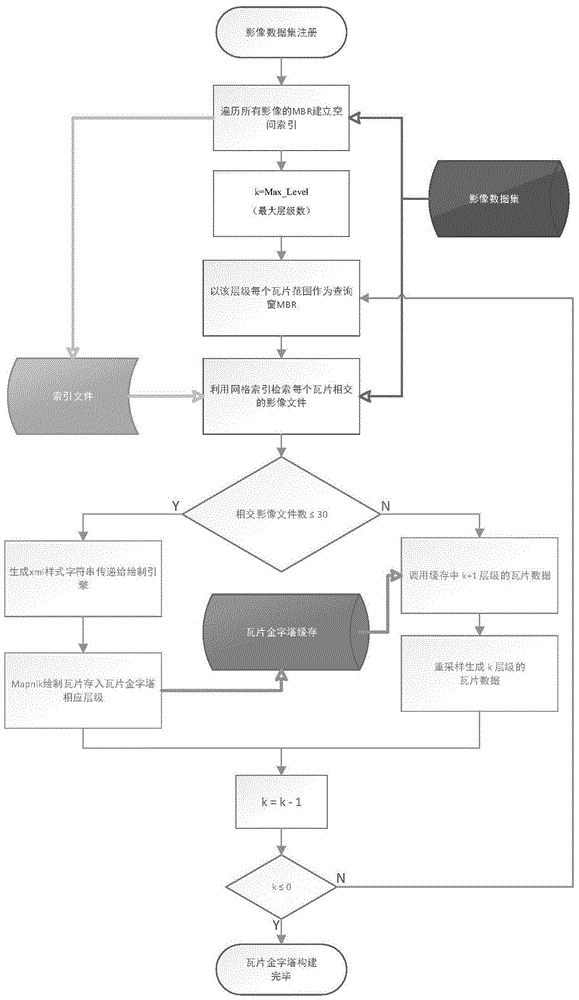
[0032] figure 1 It is a schematic diagram of the overall flow of the present invention. The specific process is as follows:

[0033](S1) Obtain a dataset containing image files; register the raster image dataset to be visualized with the map service platform.

[0034] (S2) traversing the image files in the data set, reading the minimum outsourcing frame of all image files, establishing a spatial index file, and storing the spatial index file in the file system;

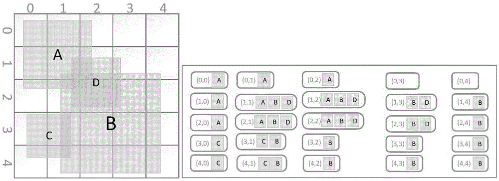
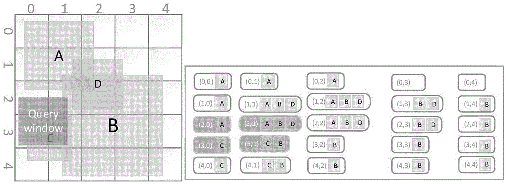
[0035] Obtain the identifier of the dataset, that is, the id that uniquely identifies the dataset in the file system, and create a corresponding index file as the basis for Mapnik to query related image files during the tile drawing process. In this embodiment, when establishing a spatial index, an intuitive grid index method is adopted in view of the spatial distribution characteristics ...


PUM


Abstract

The invention belongs to the field of treatment of geographic information, and relates to a rapid building method of a tile pyramid for a large-scale raster data set. The method comprises the steps that 1, the data set comprising image files is obtained; 2, the image files in the data set are traversed, and a spatial index file is built; 3, the tile pyramid maximum hierarchy and the image file number threshold value are set; the iteration variable k initial value is defined as the tile pyramid maximum hierarchy; 4, the current hierarchy single-tile range retrieved image file number is compared with the threshold value; if the image file number is smaller than or equal to the set threshold value, each tile in the hierarchy is traversed, an xml type character string of each tile is generated to be transferred to a Mapnik drawing engine for drawing and stored into the corresponding hierarchy of the pyramid; if the image file number is larger than the set threshold value, tile data of the existing k+1 hierarchies is called, and resampling is carried out to generate tile data of k hierarchies to be stored into the corresponding hierarchies; 5, 1 is subtracted from the current hierarchy number k, if the result is larger than 0, the step 4 is executed again, and if not, the process is finished.

Description

technical field [0001] The invention belongs to the technical field of geographic information processing, and relates to a method for quickly constructing a tile pyramid of a large-scale raster image data set in a geographic information system. Background technique [0002] With the development of geospatial data acquisition technology, many functional institutions and research groups at home and abroad have been able to obtain higher-resolution image maps more conveniently. In particular, the rapid advancement of UAV aerial photography technology has made it possible to obtain high-resolution image data sets in counties and regions. High-resolution image data is generally stored in a disk file system as a large number of raster data in the same format that is continuous in geographical distribution and discrete in file storage, but the large-scale nature of the data limits its efficient organization and indexing in traditional relational databases Access becomes the effici...

Claims


Application Information

Patent Timeline
Patent Type & Authority Applications(China)
IPC IPC(8): G06F17/30
CPCG06F16/29
Inventor 吴烨吴秋云郭宁陈荦钟志农熊伟陈浩伍江江李军景宁
Owner NAT UNIV OF DEFENSE TECH
Why Eureka
Try Eureka