Retractable device and method for side-scan and shallow-profile two-in-one landform detection

A retractable device and a two-in-one technology, applied in measuring devices, measuring the depth of open-air water sources, surveying, mapping and navigation, etc., can solve problems affecting the quality of geomorphic detection data, damage to geomorphic detection equipment, and high navigation risk, and achieve Strong operability and practicability, improved operation safety, and the effect of improving safety

Active Publication Date: 2017-03-22
SECOND INST OF OCEANOGRAPHY MNR
View PDF6 Cites 0 Cited by
  • Summary
  • Abstract
  • Description
  • Claims
  • Application Information

AI Technical Summary

Problems solved by technology

(3) Large-scale survey ships in near-shore shallow water areas or areas with dense islands and reefs have high navigation risks due to their large draft, while medium-sized survey ships’ stern towing operations are likely to cause damage to landform detection equipment, or even loss, and the ship’s stern Flow noise seriously affects the quality of geomorphic detection data

Method used


Image

  • Retractable device and method for side-scan and shallow-profile two-in-one landform detection
  • Retractable device and method for side-scan and shallow-profile two-in-one landform detection
  • Retractable device and method for side-scan and shallow-profile two-in-one landform detection

Examples


Embodiment 1

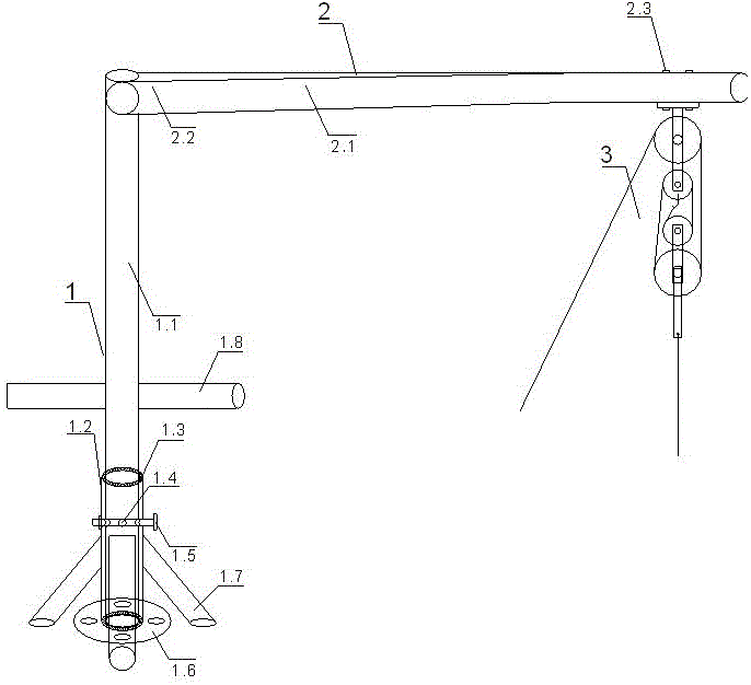
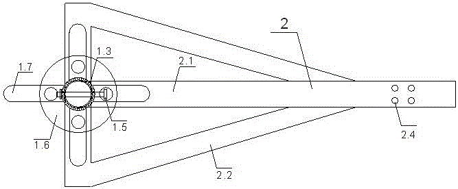
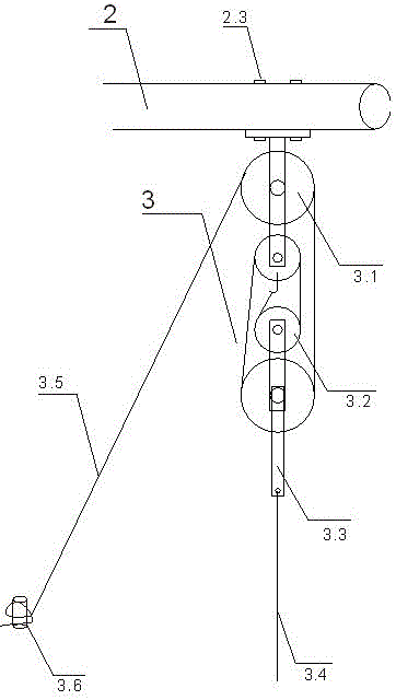
[0040] A retractable device for side-scanning and shallow profile two-in-one landform detection, refer to the attached figure 1 , 2 . figure 1 The riser 1 includes a rotating inner tube 1.1, a fixed outer tube 1.2, a bearing 1.3, a fixing screw hole 1.4, a fixing bolt 1.5, a base 1.6, a bracket 1.7, and a push rod 1.8; refer to the attached figure 1 , 2 The crossbeam 2 includes the main beam 2.1, the reinforcement rod 2.2, the pulley block fixing bolt 2.3, and the pulley block fixing screw hole 2.4; refer to the attached image 3 Pulley block 3 comprises fixed pulley 3.1, movable pulley 3.2, connecting rod 3.3, connecting steel cable 3.4, pulley block rope 3.5, pulley block rope fixed stake 3.6; Figure 4 The two-in-one landform detection towing body 4 of side scanning and shallow section includes towing frame 4.1, towing rod 4.2, towing screw holes and bolts 4.3, connecting shackle 4.4, side scanning transducer 4.5, and shallow section transducer 4.6.

[0041] Refer to at...

Embodiment 2

[0048] An application method of the retractable device for side-scanning and shallow profile two-in-one landform detection, the retractable method and operation steps are as follows:

[0049] Step 1: Installation and Inspection

[0050] 1.1) Select a flat area near the center of the survey ship 5 deck, install the overall structure of the riser 1 and beam 2, check whether the riser 1 and beam 2 are firmly fixed on the deck of the survey ship, and check the bearing 1.3. Whether it is normal, ensure that the rotating inner tube 1.1 can rotate 360 ​​degrees in the fixed outer tube 1.2;

[0051] 1.2) Check whether the pulley block 3 is firmly installed on the beam 2, check whether the fixed pulley 3.1 and the movable pulley 3.2 of the pulley block are working normally, and check whether the pulley block rope 3.5 is connected correctly;

[0052] 1.3) Check whether the towing frame 4.1, towing rod 4.2, towing screw hole and bolt 4.3 of the landform detection towing body 4 are conne...


PUM


Abstract

The invention discloses a deploying and retracting apparatus for side-scanning and shallow-profiling landform detection and a method of use thereof.The deploying and retracting apparatus comprises a vertical tube, a cross beam, a pulley set and a side-scanning and shallow-profiling landform detection tow.The pulley set is fixed to one end of the cross beam and used for lifting and lowering the landform detection tow; the vertical tube comprises a rotary inner tube and a fixed outer tube, and the rotary inner tube rotates by 360 degrees in the fixed outer tube, the rotary inner tube is rotated through a push rod to rotate the landform detection tow to the portside or starboard of a research vessel.The deploying and retracting apparatus has the advantages that the structure is simple, the practicality is high, and the problems in deploying and retracting side-scanning and shallow-profiling landform detection equipment by using small vessels in island and shallow water areas are solved; the use of the side-scanning and shallow-profiling landform detection vessel-side operation mode effectively prevents the influence from vessel stern flow noise and improves signal-to-noise ratio of landform detection data; the depth and angle of the landform detection tow in the water are flexibly adjustable so that research safety and data quality are improved.

Description

technical field [0001] The invention relates to the technical field of marine surveying and mapping and marine survey, in particular to a retractable device and method for two-in-one landform detection of side scan and shallow profile. Background technique [0002] Submarine geomorphology survey is the most basic marine survey work. In order to reveal the ups and downs of the seabed, substrate type, shallow strata structure, fault structure, magmatic activity, potential geological disasters, etc., high-resolution side scan and shallow profile Two-in-one landform detection is one of the essential survey methods. [0003] At present, (1) the detection of seabed geomorphology in open ocean or deep water areas is mainly carried out by large-scale survey ships with multi-beam and shallow strata profilers, and the resolution and accuracy of seabed geomorphology detection are not high. The medium-sized survey ship is mainly equipped with electric winches and A-frames, and the geom...

Claims


Application Information

Patent Timeline
Patent Type & Authority Patents(China)
IPC IPC(8): G01C13/00
CPCG01C13/00G01C13/008
Inventor 李守军吴自银陈佳兵尚继宏梁裕扬赵荻能周洁琼周勐佳马永
Owner SECOND INST OF OCEANOGRAPHY MNR
Why Eureka
Try Eureka