High-precision map data registration relationship determination method and device

A technology for determining map data and relationships, applied in the field of data processing, can solve problems such as low measurement accuracy and multiple workloads, and achieve the effects of reducing workload, improving accuracy, and improving user experience

Active Publication Date: 2016-06-15
BAIDU ONLINE NETWORK TECH (BEIJIBG) CO LTD
View PDF4 Cites 66 Cited by
  • Summary
  • Abstract
  • Description
  • Claims
  • Application Information

AI Technical Summary

Problems solved by technology

[0005] In view of this, the embodiments of the present invention provide a method and device for determining the registration relationship of high-precision map data to solve the problem of large workload and measurement accuracy when obtaining the registration relationship between image data and lidar point cloud data in the prior art. low problem

Method used


Image

  • High-precision map data registration relationship determination method and device
  • High-precision map data registration relationship determination method and device
  • High-precision map data registration relationship determination method and device

Examples


Embodiment 1

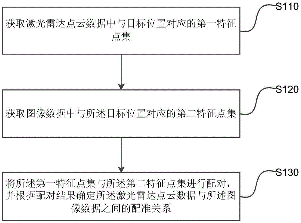
[0024] Embodiment 1 of the present invention provides a method for determining a registration relationship of high-precision map data. The method can be executed by a device for determining a registration relationship of high-precision map data, wherein the device can be implemented by software and / or hardware. figure 1 It is a flow chart of the method for determining the registration relationship of high-precision map data provided by Embodiment 1 of the present invention. Such as figure 1 As shown, the method specifically includes the following operations:

[0025] S110. Acquire a first feature point set corresponding to the target position in the lidar point cloud data.

[0026] Lidar is a radar system that detects the position, speed and other characteristics of the target by emitting laser beams. It is generally composed of a transmitting system, a receiving system, and information processing. Among them, the transmitting system is usually composed of lasers (such as c...

Embodiment 2

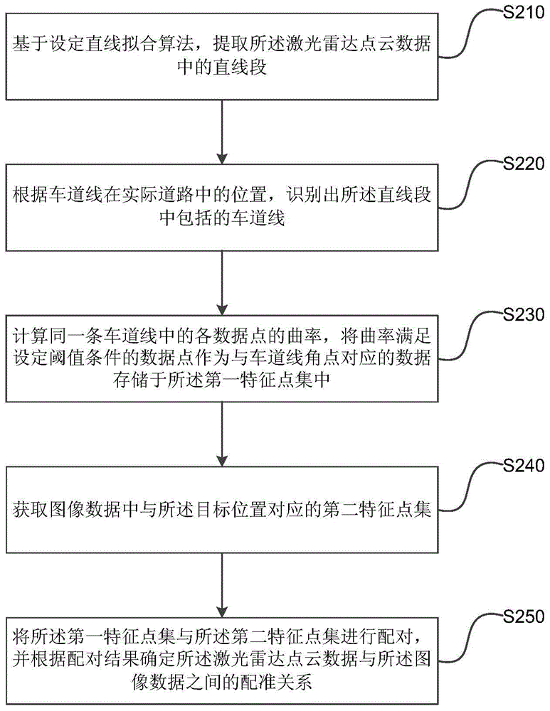
[0045] Embodiment 2 of the present invention provides a method for determining the registration relationship of high-precision map data. This embodiment is optimized on the basis of the above embodiments. In this embodiment, the points corresponding to the target position in the laser radar point cloud data The specific optimization of the first feature point set is: based on the set straight line fitting algorithm, extracting the straight line segment in the lidar point cloud data; according to the position of the lane line in the actual road, identifying the lane included in the straight line segment line; respectively calculating the curvature of each data point corresponding to the same lane line, and storing the data points whose curvature satisfies the set threshold condition as the data corresponding to the corner point of the lane line in the first feature point set.

[0046] figure 2 Shown is a flow chart of the method for determining the registration relationship of...

Embodiment 3

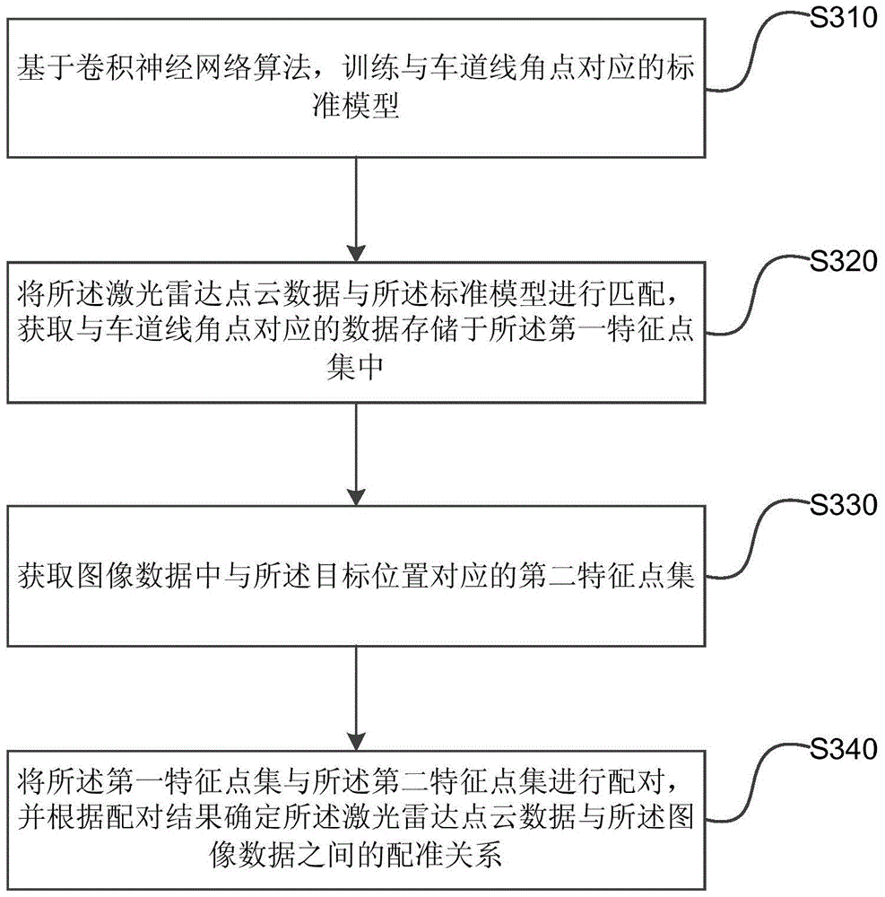
[0057] image 3 It is a flow chart of a method for determining the registration relationship of high-precision map data provided by Embodiment 3 of the present invention. This embodiment is optimized on the basis of the above-mentioned embodiments. In this embodiment, the obtained lidar point cloud data and The specific optimization of the first feature point set corresponding to the target position is as follows: based on the convolutional neural network algorithm, train the standard model corresponding to the lane line corner; match the lidar point cloud data with the standard model, and obtain the The data corresponding to the corner points of the line is stored in the first set of feature points.

[0058] Correspondingly, such as image 3 As shown, the method provided in this embodiment includes the following operations:

[0059] S310. Based on the convolutional neural network algorithm, train a standard model corresponding to the lane line corners.

[0060] Convolution...


PUM


Abstract

The embodiment of the present invention discloses a high-precision map data registration relationship determination method and device. The method comprises the steps of obtaining a first characteristic point set corresponding to a target position in the laser radar point cloud data; obtaining a second characteristic point set corresponding to the target position in the image data; pairing the first characteristic point set and the second characteristic point set, and determining a registration relationship between the laser radar point cloud data and the image data according to a pairing result. According to the embodiment of the present invention, and by adopting the above technical scheme, the registration relationship between the laser radar point cloud data and the image data can be determined without needing to set a special calibration field and measure the position of a target spot artificially, the workload needed at the registration of the laser radar point cloud data and the image data can be reduced, also the registration precision of the laser radar point cloud data and the image data can be improved effectively, and the user experience is improved.

Description

technical field [0001] The present invention relates to data processing technology, in particular to a method and device for determining registration relationship of high-precision map data. Background technique [0002] With the development of positioning and navigation technology, electronic maps have become an indispensable positioning and navigation tool in people's daily life. [0003] When collecting electronic map data, it is necessary to collect Lidar (Lidar) point cloud data and image data. Because image data contains many object element features, but lacks three-dimensional position information features; radar point cloud data contains three-dimensional position information features, but lacks object element features, so after the lidar point cloud data and image data are collected, they need to be Only through registration can a high-precision electronic map be obtained. When registering the lidar point cloud data with the image data, it is necessary to find the...

Claims


Application Information

Patent Timeline
Patent Type & Authority Applications(China)
IPC IPC(8): G06T3/00
CPCG06T3/0068
Inventor 蒋昭炎晏涛晏阳姜雨
Owner BAIDU ONLINE NETWORK TECH (BEIJIBG) CO LTD
Why Eureka
Try Eureka