Unmanned aerial vehicle navigation method based on real-time online map generation

A navigation method and map generation technology, applied in the field of UAV navigation, can solve problems such as difficulty in finding fixed reference objects

Active Publication Date: 2016-08-17
NORTHWESTERN POLYTECHNICAL UNIV
View PDF2 Cites 27 Cited by
  • Summary
  • Abstract
  • Description
  • Claims
  • Application Information

AI Technical Summary

Problems solved by technology

However, when applying vision technology, the initial information obtained by the camera exists in the form of images, accompanied by a large amount of redundant information, image processing technology is required to extract effective information, which brings the real-time problem of the algorithm
At the same time, visual navigation relies on reference objects and can only obtain relative motion state information. Therefore, it is difficult to find a suitable fixed reference object during the high-altitude flight of a single UAV, so the UAV navigation method using visual navigation is currently less used

Method used


Image

  • Unmanned aerial vehicle navigation method based on real-time online map generation
  • Unmanned aerial vehicle navigation method based on real-time online map generation
  • Unmanned aerial vehicle navigation method based on real-time online map generation

Examples


Embodiment Construction

[0060] Embodiments of the present invention are described in detail below, and the embodiments are exemplary and intended to explain the present invention, but should not be construed as limiting the present invention.

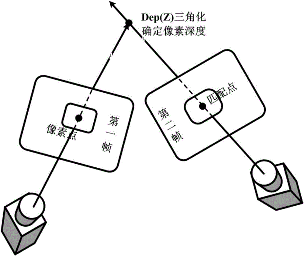
[0061] The hardware implementation of the present invention is mainly divided into two parts, the first part is the sky end, such as Figure 10 As shown, the main device is to place the microcomputer on the drone, and the drone is directly equipped with a USB camera. During the flight of the UAV, the image information is collected through the USB camera, and the data is directly sent to the microcomputer, and the microcomputer reconstructs the map of the collected image information. The image processing software of the computer provides GPS, and transmits the reconstructed map to the DDL image transmission; the microcomputer also accepts the waypoint information uploaded by the ground terminal, and performs heading flight tasks based on the route information, ...


PUM


Abstract

The invention discloses an unmanned aerial vehicle navigation method based on real-time online map generation. According to the unmanned aerial vehicle navigation method, the online reconstruction of a map on an unmanned aerial vehicle is realized, the reconstructed map is sent back to the ground through a high-bandwidth data transmission link, and a ground terminal is used for carrying out navigation decision according to a regional map sent back by the unmanned aerial vehicle, setting route information of the unmanned aerial vehicle and sending the route information to the unmanned aerial vehicle; and an aircraft-based small-size computer of the unmanned aerial vehicle carries out a directional flight task according to the route information, self-reconstructed regional map information and self-location information. By virtue of the unmanned aerial vehicle navigation method, the unmanned aerial vehicle can fly in an unknown airspace, acquires the location by virtue of the exploration and comparison of environmental information and the extraction and matching of environmental feature information when the location of the unmanned aerial vehicle is not determined and carries out the construction of a three-dimensional map and navigation. The unmanned aerial vehicle navigation method can be applied to the battlefield requirements, the emergency rescue of fire/earthquake/flood and the like and the security administration and monitoring of the unmanned aerial vehicle.

Description

technical field [0001] The present invention relates to the fields of computer image processing and map surveying and mapping, specifically a UAV navigation method based on real-time online map generation. By changing the content transmission mode of UAV and ground station, the real-time online map generation of UAV is realized. , and make mission decisions and navigation for UAVs based on online real-time generated maps. Background technique [0002] The research of Unmanned Aerial Vehicles (UAV) has made great progress in recent years, and its application fields are becoming wider and wider. In terms of military use, due to the characteristics of short warning time, good concealment, strong reconnaissance capability, long cruising time, low cost, and small combat losses, UAVs can be widely used in military tasks such as reconnaissance, attack, and electronic countermeasures. It can be used in target drone experiments; in civilian use, it can be used in communication relay...

Claims


Application Information

Patent Timeline
Patent Type & Authority Applications(China)
IPC IPC(8): G01C21/20
Inventor 布树辉杨君赵勇张臻炜
Owner NORTHWESTERN POLYTECHNICAL UNIV
Why Eureka
Try Eureka