Method and device for generating digital terrain model (DTM) data for electronic map

An electronic map and ground model technology, which is applied in image data processing, 3D image processing, 3D modeling, etc., can solve problems such as the inability to meet the application requirements of electronic maps and electronic maps, and meet the needs of quickly displaying electronic maps and speed up Efficiency and speed, data volume reduction effect

Active Publication Date: 2016-08-17
AUTONAVI
View PDF5 Cites 20 Cited by
  • Summary
  • Abstract
  • Description
  • Claims
  • Application Information

AI Technical Summary

Problems solved by technology

[0006] In view of this, the present invention provides a method and device for generating DTM data of an electronic map to overcome the technical problem that the DTM data generated in the prior art cannot meet the application requirements of electronic maps that can be clearly displayed and quickly rendered

Method used


Image

  • Method and device for generating digital terrain model (DTM) data for electronic map
  • Method and device for generating digital terrain model (DTM) data for electronic map
  • Method and device for generating digital terrain model (DTM) data for electronic map

Examples


Embodiment 1

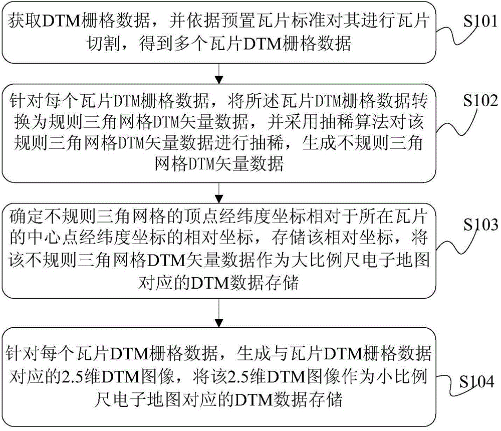
[0029] Such as figure 1 As shown, it is a flowchart of a method for generating DTM data of an electronic map provided by Embodiment 1 of the present invention, which mainly includes the following steps:

[0030] Step S101, obtaining DTM raster data, and performing tile cutting on the DTM raster data according to preset tile standards, to obtain multiple tile DTM raster data;

[0031] Execute step S101, perform tile segmentation on the acquired DTM raster data according to the preset tile standard, and store the multiple tile DTM raster data obtained after cutting in the preset DTM table.

[0032] Wherein, the preset tile standard may include tile size, format, and the like. A tile refers to a square grid image that cuts the electronic map into several rows and columns according to a certain size and format, according to the zoom level or scale. For the sliced ​​square grid image, each tile has a unique id , the id can be a positive integer. The DTM table looks like this:

...

Embodiment 2

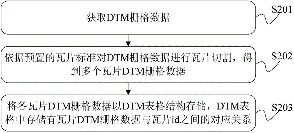
[0045] A method for generating DTM data based on an electronic map disclosed in Embodiment 1, figure 1 In step S101 shown in , the DTM raster data is obtained, and the DTM raster data is cut according to the tile standard to obtain the tile DTM raster data, such as figure 2 As shown, it mainly includes the following steps:

[0046] Step S201, acquiring DTM grid data;

[0047] Step S202, performing tile cutting on the DTM raster data according to the preset tile standard to obtain multiple tile DTM raster data;

[0048] Step S203, storing each of the tile DTM raster data in a DTM table structure, and the DTM table stores the corresponding relationship between the tile DTM raster data and the tile id.

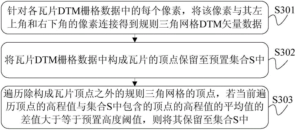
[0049] Based on a method for generating electronic map DTM data disclosed in Embodiment 1, figure 1 In step S102 shown in , for each tile DTM raster data, convert the tile DTM raster data into regular triangular grid DTM vector data, and use a thinning algorithm to convert th...

Embodiment 3

[0080] Such as Figure 6 As shown, it is a schematic structural diagram of an electronic map DTM data generating device disclosed in an embodiment of the present invention, which mainly includes: a first processing unit 11 , a conversion unit 12 , a second processing unit 13 , and a third processing unit 14 .

[0081] Wherein, the first processing unit 11 is configured to acquire DTM raster data, and perform tile cutting on the DTM raster data according to a preset tile standard, to obtain a plurality of tile DTM raster data;

[0082] The conversion unit 12 is configured to convert the tile DTM raster data into regular triangular grid DTM vector data for each tile DTM raster data, and use a thinning algorithm to convert the regular triangular grid DTM vector data Perform thinning to generate irregular triangular grid DTM vector data;

[0083] The second processing unit 13 is configured to determine the relative coordinates of the latitude and longitude coordinates of the vert...


PUM


Abstract

The embodiment of the invention discloses a method and a device for generating digital terrain model (DTM) data for an electronic map. DTM raster data are converted and segmented into multiple tile DTM raster data, the tile DTM raster data are converted into DTM vector data of a regular triangular mesh, a thinning algorithm is adopted to thin the DTM vector data of the regular triangular mesh, DTM vector data of an irregular triangular mesh are generated, and the DTM vector data of the irregular triangular mesh serve as DTM data corresponding to a large-scale electronic map; and as for each piece of tile DTM raster data, a 2.5-dimensional DTM image corresponding to the tile DTM raster data is generated, and the 2.5-dimensional DTM image serves as DTM data corresponding to a small-scale electronic map. Through the above mode, clear demonstration application requirements by the large-scale electronic map can be met, and quick rendering application requirements by the small-scale electronic map can also be met.

Description

technical field [0001] The invention relates to the field of electronic mapping, in particular to a method and device for generating digital terrain model (DTM) data of an electronic map. Background technique [0002] With the development of navigation technology, the digital terrain model (hereinafter referred to as DTM) occupies an increasingly important position in the field of electronic navigation maps. At present, in the process of generating DTM data on industrialized products of electronic navigation maps in the industry, DTM data mainly includes three Types: The first type is regular triangular mesh DTM vector data, which is composed of triangles of equal size and is often used for surface modeling of irregular objects; the second type is irregular triangular mesh DTM vector data (TIN), It is usually composed of a series of triangles of different sizes, and is also commonly used for surface modeling of irregular objects; the third is a 2.5-dimensional DTM image, whi...

Claims


Application Information

Patent Timeline
Patent Type & Authority Applications(China)
IPC IPC(8): G06T15/00G06T17/05
CPCG06T15/00G06T17/05
Inventor 朱玟征贾双成
Owner AUTONAVI
Why Eureka
Try Eureka