Mountain foot water surface scale analyzing method based on mountain land catchment calculation

An analysis method and water collection technology, applied in calculation, design optimization/simulation, CAD numerical modeling, etc., can solve the problems of lack of simulation calculation methods and applications, lack of rational analysis support of technical data, etc., and achieve rational analysis and judgment Effect

Active Publication Date: 2016-11-09
SOUTHEAST UNIV
View PDF3 Cites 8 Cited by
  • Summary
  • Abstract
  • Description
  • Claims
  • Application Information

AI Technical Summary

Problems solved by technology

In the engineering practice of water conservancy, urban planning and landscape planning, there is a lack of rational analysis support of technical data, especially the lack of methods and applications for the simulation calculation of water catchment and water surface area at the foot of the mountain from the perspective of three-dimensional space

Method used


Image

  • Mountain foot water surface scale analyzing method based on mountain land catchment calculation
  • Mountain foot water surface scale analyzing method based on mountain land catchment calculation
  • Mountain foot water surface scale analyzing method based on mountain land catchment calculation

Examples


Embodiment Construction

[0047] The present invention will be further clarified below in conjunction with a specific embodiment in a mountainous area.

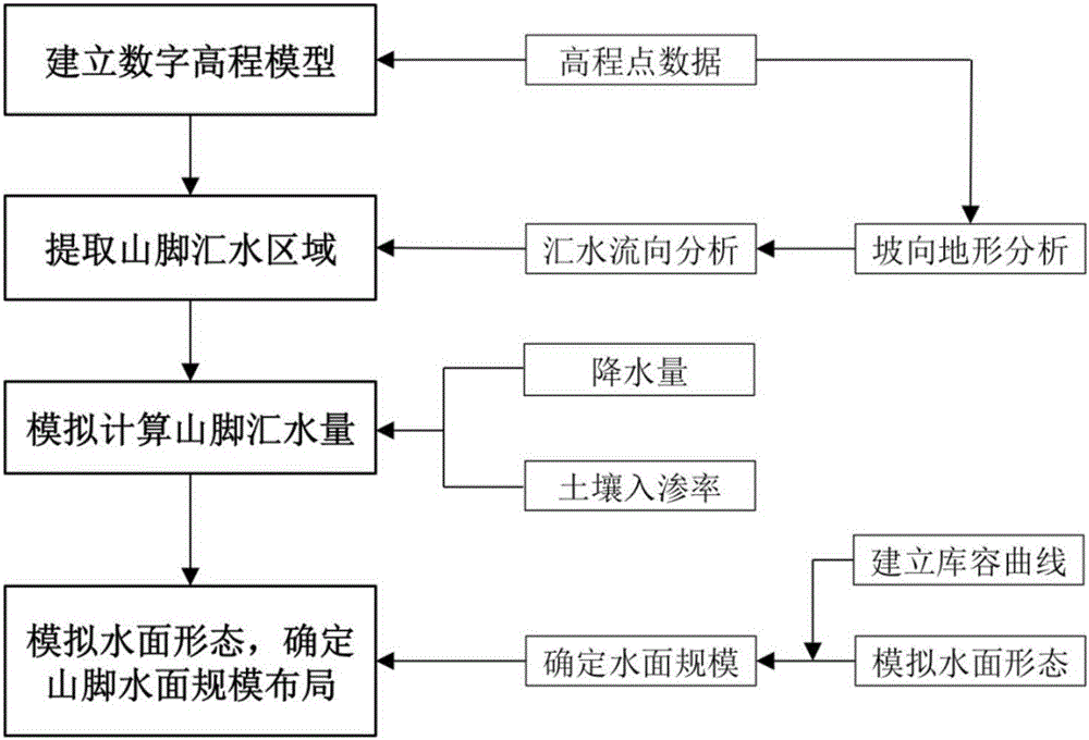
[0048] Such as figure 1 As shown, a method for analyzing the scale of water surface at the foot of a mountain based on mountain water catchment calculation, the specific steps are as follows:

[0049] 1) Establish a digital elevation model according to the topographic elevation point data of a mountainous area;

[0050] 1.1) Import the topographic map vector file of a mountainous area into AutoCAD software, set the coordinate system and divide it into different layer types, these layer types include elevation point data layer, contour layer, building and environment layer, etc. . Store the processed vector data dwg file in dxf format;

[0051] 1.2) Create a new layer in ArcGIS geographic analysis software, import the elevation point data layer required to establish a digital elevation model, and set the layer coordinate system. Other layers are im...


PUM


Abstract

The invention discloses a mountain foot water surface scale analyzing method based on mountain land catchment calculation. The method includes the steps of establishing a digital elevation model according to mountain land elevation point data, conducting catchment analysis to extract mountain foot catchment based on the digital elevation model, conducting mountain foot catchment amount analog calculation through precipitation amount and soil infiltration rate, simulating water surface form, and determining the mountain foot water surface scale layout. According to the method, catchment calculation, analysis and simulation are conducted based on three-dimensional surfaces through a computer information technology, and then a quantitative method is provided for mountain foot water surface scale analysis; rational technological means is provided for water surface form simulation and layout engineering practice; data support is provided for flood control and drainage and natural water storage through water surface scale calculation and analysis, rational analysis and judgment are effectively achieved, and therefore the method can better assist in water conservancy project, urban planning project and landscape planning project practice.

Description

technical field [0001] The invention relates to an analysis method for planning engineering practice, in particular to a method for analyzing the scale of water surface at the foot of a mountain based on mountain water catchment calculation. Background technique [0002] With the rapid development of computer technology and information processing technology, in order to meet the automation requirements of various water conservancy, landscape and planning projects, 3D information technology has gradually received attention in the field of water conservancy, landscape and planning engineering practice. As an important method of GIS three-dimensional surface analysis, mountain water catchment analysis uses the rich spatial information contained in the three-dimensional surface to express the characteristic information of terrain undulations. The scale of the water surface at the foot of the mountain is determined through the scope and catchment calculation, which provides solid...

Claims


Application Information

Patent Timeline
Patent Type & Authority Applications(China)
IPC IPC(8): G06F17/50
CPCG06F30/20G06F2111/10Y02A10/40
Inventor 杨俊宴陆小波
Owner SOUTHEAST UNIV
Why Eureka
Try Eureka