Water-saving irrigation monitoring network location method based on RSSI ranging

A positioning method and network monitoring technology, which can be applied in the service, positioning, network topology and other directions based on location information, and can solve problems such as reducing the accuracy of ranging

Active Publication Date: 2016-11-16
HUAIYIN INSTITUTE OF TECHNOLOGY
View PDF3 Cites 20 Cited by
  • Summary
  • Abstract
  • Description
  • Claims
  • Application Information

AI Technical Summary

Problems solved by technology

Different areas or different directions in the environment can make the RSSI value different. This adverse effect is mainly reflected in the path loss factor, and the use of a fixed path loss empirical value will reduce the ranging accuracy due to the change of the signal propagation area.

Method used


Image

  • Water-saving irrigation monitoring network location method based on RSSI ranging
  • Water-saving irrigation monitoring network location method based on RSSI ranging
  • Water-saving irrigation monitoring network location method based on RSSI ranging

Examples


Embodiment Construction

[0070] The present invention will be further described below.

[0071] A water-saving irrigation monitoring network positioning method based on RSSI ranging, comprising the following steps:

[0072] Step 1: Use signal propagation modeling to quickly obtain distance information of monitoring nodes;

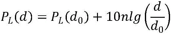
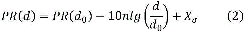
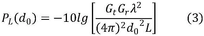
[0073] In the soil environment where the water-saving irrigation monitoring system is used, the internal soil quality is different and other organisms are dense and unevenly distributed, resulting in multipath, diffraction and obstacle blocking, making the RF wireless signal propagation model complex. The monitoring node itself can provide RSSI measurement without adding additional hardware devices. The path loss of wireless signal propagation has a great influence on the accuracy of RSSI measurement. The logarithmic-normal distribution model is adopted, and the RSSI value is expressed as

[0074] PR(d)=P+G-P L (d) (1)

[0075] Among them, P and G are transmit power and antenna...


PUM


Abstract

The invention discloses a water-saving irrigation monitoring network location method based on RSSI ranging. The method comprises the following steps of S1, rapidly acquiring distance information of a monitoring node by using signal propagation and modeling; S2, acquiring relative error coefficients of anchor nodes by comparing measured distances between the anchor nodes with actual distances and acquiring differences, so as to correct measured distances between the monitoring node and the anchor nodes in a communication range of the monitoring node; S3, computing a coordinate of the monitoring node by using a ranging weighted centroid location algorithm; and S4, correcting the coordinate of the monitoring node. The method fully considers influences of RSSI ranging errors and the quantity of the anchor nodes on the location accuracy, so that a good location effect can be achieved, and the location requirement of a large farmland irrigated area soil moisture content monitoring system with bad network environment and limited location cost can be met, and compared with a common L basic location algorithm, the method of the invention has higher location accuracy and lower computation complexity.

Description

technical field [0001] The invention relates to a water-saving irrigation monitoring network positioning method based on RSSI ranging. Background technique [0002] In order to keep abreast of the environmental soil moisture in farmland irrigation areas and improve production quality, based on the actual needs of the farmland automatic water-saving irrigation monitoring system and the actual needs of the location of the water-saving irrigation monitoring nodes, it is necessary to monitor the wireless sensor network for farmland automatic water-saving irrigation monitoring. The monitoring nodes are located. [0003] Wireless sensor networks (wireless sensor networks, WSN) are composed of a large number of miniature low-power sensor nodes in a self-organizing and multi-hop manner, which can sense, collect and wirelessly transmit environmental information in the monitoring area, and have cooperative distributed processing capabilities. It has become one of the data processing ...

Claims


Application Information

Patent Timeline
Patent Type & Authority Applications(China)
IPC IPC(8): H04W4/04H04W84/18G01S5/02G01S5/10
CPCG01S5/021G01S5/10H04W4/04H04W84/18
Inventor 张新荣常波徐保国
Owner HUAIYIN INSTITUTE OF TECHNOLOGY
Why Eureka
Try Eureka