Method for extracting vegetation canopy aggregation degree index based on three-dimensional laser point cloud

A three-dimensional point cloud and three-dimensional laser technology, applied in the direction of using optical devices, measuring devices, instruments, etc., can solve the problems of light conditions and inconvenient data acquisition of scale selection, and achieve the effects of no side effects of vegetation, accurate extraction, and easy data collection.

Active Publication Date: 2016-12-21
UNIV OF ELECTRONICS SCI & TECH OF CHINA
View PDF10 Cites 19 Cited by
  • Summary
  • Abstract
  • Description
  • Claims
  • Application Information

AI Technical Summary

Problems solved by technology

[0006] In view of the above existing problems or deficiencies, in order to solve the problems of light conditions, scale selection, and data acquisition inconvenience, the present invention provides a method for extracting vegetation canopy aggregation index from three-dimensional laser point cloud

Method used


Image

  • Method for extracting vegetation canopy aggregation degree index based on three-dimensional laser point cloud
  • Method for extracting vegetation canopy aggregation degree index based on three-dimensional laser point cloud
  • Method for extracting vegetation canopy aggregation degree index based on three-dimensional laser point cloud

Examples


Embodiment Construction

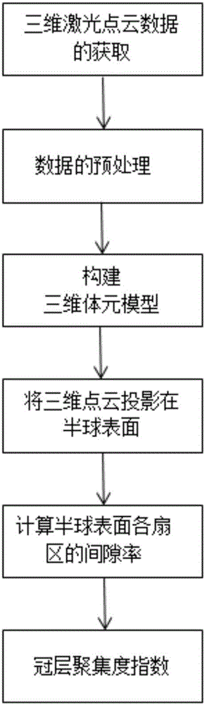
[0034] Below by example and in conjunction with accompanying drawing the present invention will be further described:

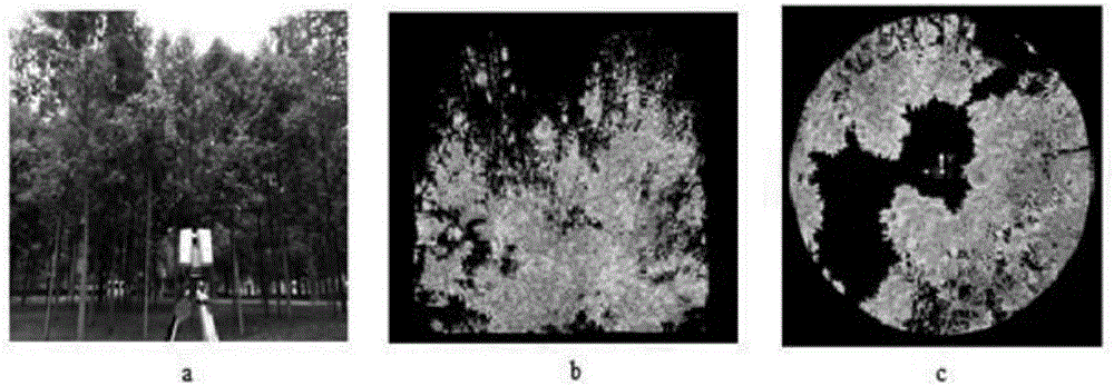
[0035] Step 1, taking the magnolia tree sample quadrat as the research object (area 10m*10m, average tree height about 7m), using the ground three-dimensional laser scanner Leica ScanStation C10 (its parameters are shown in Table 1) at the center of the sample plot and individual Multi-station scanning is performed on the side, the height of the scanner from the ground is 1 meter, and the scanning resolution is high resolution. After data registration, the ground point cloud and other noise point clouds were manually removed to obtain the canopy 3D point cloud data of the magnolia tree quadrat, as shown in the attached figure 2 Show.

[0036] Table 1 Parameters of 3D laser scanner Leica ScanStation C10

[0037]

[0038]

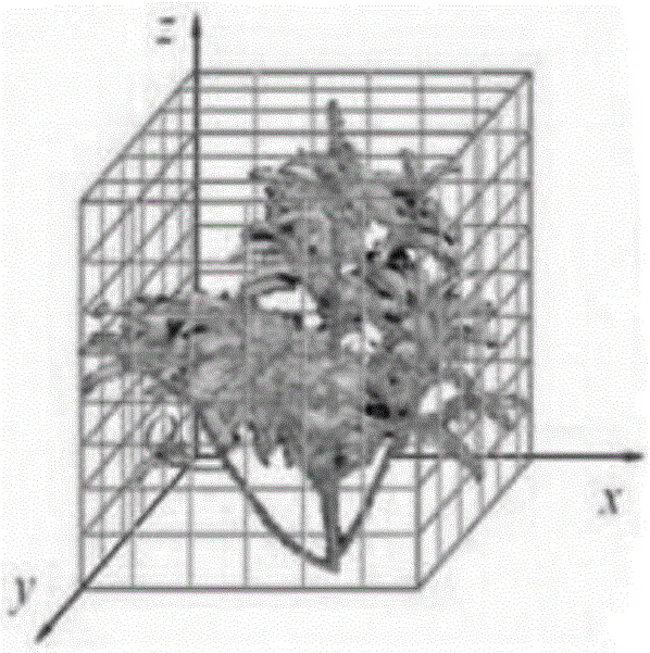
[0039] Step 2. After obtaining the canopy 3D point cloud data of the magnolia tree quadrat and preprocessing, use the voxel method...


PUM


Abstract

The invention belongs to the technical field of the laser radar remote sensing technology and particularly provides a method for extracting a vegetation canopy aggregation degree index based on the three-dimensional laser point cloud. According to the technical scheme of the invention, the remote sensing technology is adopted to obtain the three-dimensional point cloud data of a vegetation quadrat canopy. Through the processes of constructing a three-dimensional volume element model, converting a coordinate system, calculating a canopy clearance rate and the like, a method for extracting the vegetation canopy aggregation degree index based on ground high-resolution laser point cloud data is established. Based on the method, the vegetation canopy aggregation degree index can be quickly and accurately extracted, and the data acquisition is simple and convenient. Meanwhile, the process is not influenced by the lighting condition during observation. During the study, the pixel scale factor of satellite remote sensing data or products is not taken into consideration. Moreover, no adverse effect on vegetation structure and radiation characteristics exists. At the same time, the three-dimensional structural features of a vegetation sample can be permanently recorded. The method is simple, convenient and efficient, and does not have side effects on vegetation. The calculated amount is greatly reduced compared with the prior art.

Description

technical field [0001] The invention belongs to the technical field of laser radar remote sensing, and relates to a method for evaluating forest canopy aggregation using point cloud data acquired by a ground three-dimensional laser scanner, specifically a method for extracting vegetation canopy aggregation index from three-dimensional laser point clouds . Background technique [0002] Vegetation canopy is the most direct and active interface layer where vegetation interacts with the external environment, and it has an important impact on ecosystem material, energy exchange, biodiversity, and climate change. Canopy structure is an important aspect of canopy research, and an accurate description of vegetation canopy structure is an important basis for understanding the pattern, process and operating mechanism of vegetation ecosystems. In fact, the canopy structure of vegetation is not randomly distributed, and the canopy leaves of vegetation will be aggregated to varying degr...

Claims


Application Information

Patent Timeline
Patent Type & Authority Applications(China)
IPC IPC(8): G01B11/28G01B5/00
CPCG01B5/0035G01B11/28
Inventor 李世华梁祖琴
Owner UNIV OF ELECTRONICS SCI & TECH OF CHINA
Why Eureka
Try Eureka