Method for inverting topsoil volumetric water content by employing multi-temporal observation data of geostationary meteorological satellite

A static meteorological satellite and observation data technology, applied to measuring devices, using re-radiation, radio wave measurement systems, etc., can solve the problems of lack of and inability to directly invert soil volume moisture content, etc.

Inactive Publication Date: 2017-01-04
UNIVERSITY OF CHINESE ACADEMY OF SCIENCES +1
View PDF3 Cites 5 Cited by
  • Summary
  • Abstract
  • Description
  • Claims
  • Application Information

AI Technical Summary

Problems solved by technology

The lack of polar-orbiting satellite data information (up to one or two images per day) has to some extent caused some problems in remote sensing soil moisture retrieval to be unresolved. For example, it is usually necessary to establish a remote sensing retrieval surface The empirical relationship between parameters (thermal inertia, temperature, vegetation drought index, and evapotranspiration, etc.) and surface soil moisture observations is used to invert regional soil moisture, and quantitative soil volume moisture content cannot be directly inverted.

Method used


Image

  • Method for inverting topsoil volumetric water content by employing multi-temporal observation data of geostationary meteorological satellite
  • Method for inverting topsoil volumetric water content by employing multi-temporal observation data of geostationary meteorological satellite
  • Method for inverting topsoil volumetric water content by employing multi-temporal observation data of geostationary meteorological satellite

Examples


Embodiment Construction

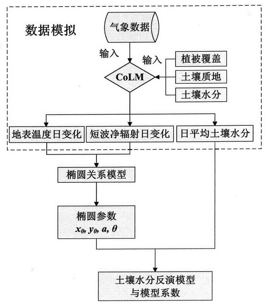
[0020] figure 1 The research flowchart for developing the soil moisture retrieval model for this study is shown. In the data simulation, we considered different vegetation coverage, soil texture and soil moisture. After obtaining the simulated data, we used a multiple linear stepwise regression method to determine the elliptic parameters (x 0 the y 0 , a, θ).

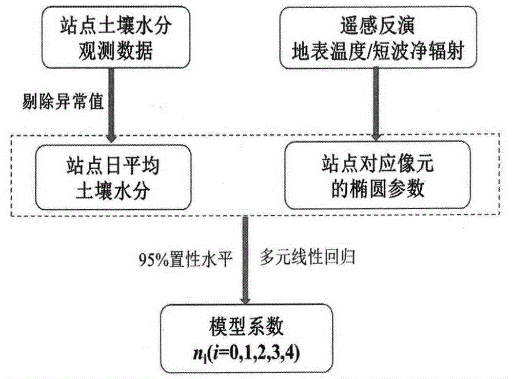
[0021] figure 2 A method for obtaining model coefficients using geostationary meteorological satellite data and surface soil moisture observation data is shown. Among them, the surface temperature and surface short-wave net radiation retrieved from stationary meteorological satellite data under sunny conditions are dimensionless, and the least squares method is used to fit the elliptic relationship model between the surface temperature and surface short-wave net radiation, and the ellipse parameters are calculated. At the same time, the average value of the soil moisture observation data in the pixel is selected t...


PUM


Abstract

The invention discloses a method for inverting topsoil volumetric water content by employing multi-temporal observation data of a geostationary meteorological satellite. The method mainly includes: a soil moisture inversion model is built; the land surface temperature and net surface shortwave radiation are inverted in a quantification manner by employing the data of the geostationary meteorological satellite, dimensionless treatment is performed on the land surface temperature and the net surface shortwave radiation, ellipse fitting is performed on the multi-temporal land surface temperature and the net surface shortwave radiation, an ellipse parameter corresponding to each pixel is obtained, and the parameters are regarded as input data of the soil moisture inversion model; an acquisition method of model coefficients is obtained; and specific requirements of dimensionless treatment are imposed on the land surface temperature and the net surface shortwave radiation. According to the method, the problems caused by the lack of polar orbiting satellite data information of the conventional optical and thermal infrared remote sensing soil moisture inversion method are solved.

Description

technical field [0001] The invention relates to a method for retrieving volumetric water content of surface soil by using multi-temporal observation data of stationary meteorological satellites. Background technique [0002] Soil moisture is one of the key parameters of water balance and energy balance. It is the core and link connecting surface water, groundwater and bio-earth cycle. It plays a very important role in the research fields of hydrology, climate, agriculture and ecology. Most of the current optical and thermal infrared remote sensing soil moisture retrieval methods are developed on the basis of earth observation by polar-orbiting satellites. The lack of polar-orbiting satellite data information (up to one or two images per day) has to some extent caused some problems in remote sensing soil moisture retrieval to be unresolved. For example, it is usually necessary to establish a remote sensing retrieval surface The empirical relationship between parameters (ther...

Claims


Application Information

Patent Timeline
Patent Type & Authority Applications(China)
IPC IPC(8): G01S7/48G01S17/95
CPCG01S7/4802G01S17/95Y02A90/10
Inventor 宋小宁李召良冷佩唐伯惠李小涛
Owner UNIVERSITY OF CHINESE ACADEMY OF SCIENCES
Why Eureka
Try Eureka