Non-vegetation-covered area airborne LiDAR data echo intensity value correction method

A technology of echo intensity and correction method, which is applied in the field of remote sensing surveying and mapping, and can solve problems such as limited echo intensity values, difficulties in obtaining accurate atmospheric parameters, and difficulties in the application of radar equations

Active Publication Date: 2017-01-04
BEIJING RES INST OF URANIUM GEOLOGY
View PDF3 Cites 7 Cited by
  • Summary
  • Abstract
  • Description
  • Claims
  • Application Information

AI Technical Summary

Problems solved by technology

But in reality, many basic parameters of lidar equipment are difficult to obtain, so the application of radar equations is more difficult, and it

Method used


Image

  • Non-vegetation-covered area airborne LiDAR data echo intensity value correction method
  • Non-vegetation-covered area airborne LiDAR data echo intensity value correction method
  • Non-vegetation-covered area airborne LiDAR data echo intensity value correction method

Examples


Embodiment Construction

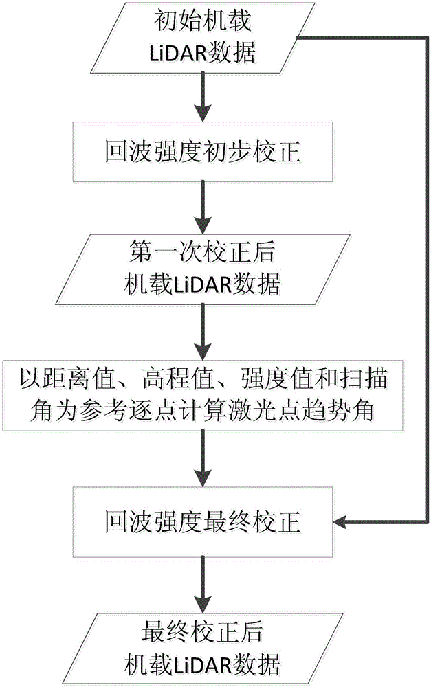
[0101] A method for correcting echo intensity values ​​of airborne LiDAR data in non-vegetated coverage areas of the present invention will be described in detail below in conjunction with the accompanying drawings and embodiments.

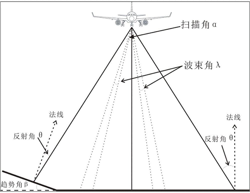
[0102] The scanning operation process of airborne lidar is as follows: figure 1 shown. The airborne LiDAR operates in a sweeping mode. When the ground objects scanned by the laser spot are horizontal, such as figure 1 As shown on the right, the reflection angle θ is equal to the scanning angle α; but the local object has a certain trend angle β in the scanning direction, such as figure 1 On the left, the reflection angle θ is equal to the scan angle α minus the trend angle β. As mentioned in the background technology, the traditional normalization correction method all assumes that the ground is a Lambertian body, and the laser reflection angle is equal to the incident angle (ie, the scanning angle), ignoring the influence of the inclination ...


PUM


Abstract

The invention belongs to the technical field of remote sensing and mapping, and specifically relates to a non-vegetation-covered area airborne LiDAR data echo intensity value correction method. The method includes following steps: performing primary correction of an echo intensity value based on the flying height and the laser point elevation value, and performing homogenization on the influences of the laser transmission distance on the echo intensity value; calculating the tendency angle values of laser points point by point by setting a threshold determination condition and taking the plane distance value, the elevation value and the echo intensity value as references based on LiDAR data after primary correction; and calculating the reflection angle with the combination of the tendency angle and an incidence angle, and performing correction calculation on the echo intensity value of the original LiDAR data again. According to the method, the technical problem of difficult realization of airborne LiDAR data echo intensity value correction of non-vegetation surface features, especially inclined surface features in the prior art is solved, the airborne LiDAR data echo intensity value can better reflect the surface feature media attributes, and the application values thereof in surface feature classification and identification are improved.

Description

technical field [0001] The invention belongs to the field of remote sensing surveying and mapping, and relates to a method for correcting echo intensity values ​​of airborne LiDAR data. Background technique [0002] Airborne LiDAR (Airborne Light Detection And Ranging, LIDAR) is a new type of measurement technology that has developed rapidly in the past ten years. Generate digital products such as DEM. The laser point cloud data is that the laser rangefinder emits laser light to the ground, and calculates the three-dimensional coordinates of the ground point by calculating the angle of the emitted laser light and the return time of the pulse signal. In addition to spatial coordinate information, the content recorded in the lidar point cloud data also includes information such as echo intensity, echo sequence, and scanning angle. Among them, the echo intensity value is the laser pulse signal returned after being reflected by the ground object, which is induced by the receiv...

Claims


Application Information

Patent Timeline
IPC IPC(8): G01S7/48
CPCG01S7/4802
Inventor 伊丕源童鹏钱坤赵英俊吴文欢
Owner BEIJING RES INST OF URANIUM GEOLOGY
Why Eureka
Try Eureka