Beidou RDSS-based satellite navigation and positioning service monitoring system in complex environment condition

A satellite navigation and positioning service technology, applied in the field of satellite navigation and positioning, can solve problems such as service performance monitoring and evaluation limitations, and achieve the effect of simple and reliable platform equipment and strong mobility

Inactive Publication Date: 2017-02-01
SHAANXI NAVI INFORMATION TECH
View PDF5 Cites 2 Cited by
  • Summary
  • Abstract
  • Description
  • Claims
  • Application Information

AI Technical Summary

Problems solved by technology

[0004] The purpose of the present invention is to provide a satellite navigation and positioning service monitoring system based on Beidou RDSS under complex environmental conditions, aiming at solving the limitation of monitoring and evaluating the service performance of Beidou, GPS and GLONASS under the complex environment and high mobility requirements The problem

Method used


Image

  • Beidou RDSS-based satellite navigation and positioning service monitoring system in complex environment condition
  • Beidou RDSS-based satellite navigation and positioning service monitoring system in complex environment condition

Examples


Embodiment Construction

[0019] In order to make the object, technical solution and advantages of the present invention more clear, the present invention will be further described in detail below in conjunction with the examples. It should be understood that the specific embodiments described here are only used to explain the present invention, not to limit the present invention.

[0020] The application principle of the present invention will be further described below in conjunction with the accompanying drawings and specific embodiments.

[0021] refer to figure 1 and figure 2 :

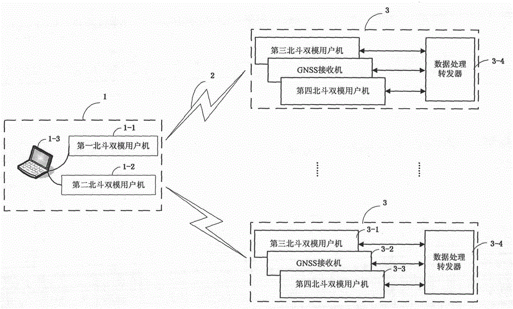
[0022] The present invention is realized in this way. A satellite navigation and positioning service monitoring system based on Beidou RDSS complex environment conditions includes a main control and monitoring system 1, a remote monitoring subsystem 2 and corresponding control and monitoring units.

[0023] 1. The control and monitoring main system 1 is mainly composed of computer 1-3 (or notebook computer), the first...


PUM


Abstract

The invention discloses a Beidou RDSS-based satellite navigation and positioning service monitoring system in a complex environment condition. A control monitoring main system comprises a Beidou user, a computer, a control unit and a monitoring display unit. Multiple remote monitoring subsystems are distributed in different regions, and each remote monitoring subsystem comprises a Beidou user, a GNSS receiver and a data processing transponder. An instruction data interface protocol comprises a navigation terminal positioning mode, a data frequency, a serial port parameter, a data reporting mode and a data transmission content arrangement protocol format. In complex environment and fast maneuvering conditions, continuous work and system monitoring in non-network and complicated environment regions can be realized, simplicity and reliability are realized, the maneuverability is strong, an unattended function and a remote control function are realized, and strong guarantee is provided for real-time monitoring on the service performance of the Beidou system and the GPS/GLONASS.

Description

technical field [0001] The invention belongs to the technical field of satellite navigation and positioning, and in particular relates to a satellite navigation and positioning service monitoring system based on Beidou RDSS complex environment conditions. Background technique [0002] After the Beidou satellite navigation system was officially put into operation and provided services, it has been widely used in the fields of national economy and national defense such as transportation, water conservancy, electric power, forestry, petrochemical, agriculture and ocean. The monitoring stations of relevant domestic organizations and units in the Beidou coverage area The distribution of points and the monitoring and evaluation of Beidou service performance provide an important reference for the use of Beidou and provide a strong guarantee for the stable operation of the system. The monitoring data of the user machines in the monitoring station are sent back to the monitoring cent...

Claims


Application Information

Patent Timeline
Patent Type & Authority Applications(China)
IPC IPC(8): G01S19/42
CPCG01S19/42
Inventor 王蓓蓓刘晓雅杨生申俊飞郑冲陈金春田斌李锐张浩戴弦
Owner SHAANXI NAVI INFORMATION TECH
Why Eureka
Try Eureka