Geological section map online generation method based on nonlinear fitting control

A non-linear fitting, geological profile technology, applied in the application field of information technology and geotechnical engineering, can solve problems such as long working hours, strong software dependence, and many human interventions, and achieve improved work efficiency and intelligent High-level, fast-running effects

Inactive Publication Date: 2017-03-08
SUN YAT SEN UNIV
View PDF5 Cites 16 Cited by
  • Summary
  • Abstract
  • Description
  • Claims
  • Application Information

AI Technical Summary

Problems solved by technology

However, these methods require software installation, high drawing costs, strong dependence on software, and cannot realize full relational storage of graphics and attributes.
Since it cannot be combined with GIS, a large amount of data must be input before each drawing, the working hours are long, the efficiency is low, and there are many human interventions, so it is impossible to realize intelligent analysis and graphing

Method used


Image

  • Geological section map online generation method based on nonlinear fitting control
  • Geological section map online generation method based on nonlinear fitting control
  • Geological section map online generation method based on nonlinear fitting control

Examples


Embodiment Construction

[0026] The present invention will be further described below with reference to the accompanying drawings and engineering practice.

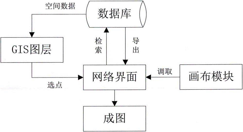
[0027] Online automatic drawing of geological profiles by writing network scripting language, mainly including: drilling business layer, establishment and connection of database, data calling and classification storage, analysis and processing of complex strata, stratigraphic boundary point fitting, legend filling , dynamic ruler and legend description, the specific implementation steps are as follows:

[0028] 1. Establishment and connection of drilling business layer and database.

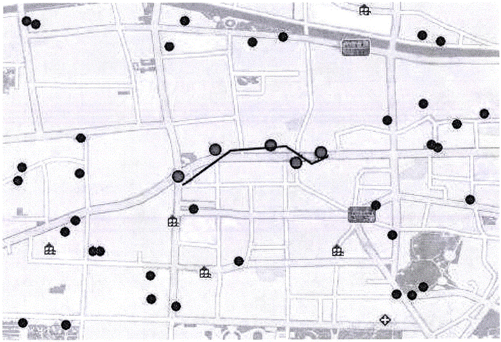
[0029] (1) Publish the drilling business layer based on the GIS platform, assign each drilling hole to different ID and attribute elements, and call the layer service through the online geographic information system to realize the display and attribute output of the drilling point on the network page, such as figure 1 shown, call out the drilling point as the opera...


PUM


Abstract

The invention discloses a geological section map online generation method based on nonlinear fitting control. Distribution condition of each earth layer underground along a certain depth can be researched. Normalized processing can be carried out on complex stratums by compiling a network script language. For landforms such as pinch-out, inversion and deficiency possibly occurring in the stratums, the drilling stratums are numbered, rearranged and combined. Virtual serial numbers are added to the drilling stratums, thereby forming new numbered matrixes as the basis for connecting stratum boundaries. The stratum boundaries are smoothly connected based on three times of bezier curve fitting. According to the method, drilling service map layers can be displayed on a network platform, drilling information stored in a database can be called in real time, a user can randomly pick up drilling points on line, thereby finishing drawing a geological section map, the whole process is simple and convenient in operation, and the map forming effect is good.

Description

technical field [0001] The invention belongs to the field of combined application of information technology and geotechnical engineering, and relates to an online generation method for a geological profile diagram based on nonlinear fitting control, which is suitable for automatically generating a geological profile diagram on a network platform through computer assistance. Background technique [0002] The geological profile can effectively analyze the vertical structure of the lower part of the stratum, including the lithology of the stratum, the boundary of the ore body, the engineering geological characteristics, the hydrological characteristics and the structural form, etc. value, so it is widely used. At present, the methods of drawing geological profiles mainly use compiled data files to generate maps directly from the graphic data exchange format, or convert data into image information for drawing through other drawing tools combined with a certain programming langua...

Claims


Application Information

Patent Timeline
Patent Type & Authority Applications(China)
IPC IPC(8): G06F17/50G06T17/05
CPCG06T17/05G06F30/18
Inventor 周翠英梁宁刘镇陆仪启苏定立杜子纯
Owner SUN YAT SEN UNIV
Why Eureka
Try Eureka