Unmanned aerial vehicle airborne LiDAR point cloud filtering method based on adaptive gradient

A self-adaptive, gradient technology, applied in computer parts, image data processing, instruments, etc., to achieve the effect of improving search efficiency and improving operation efficiency

Active Publication Date: 2017-03-22
NORTH CHINA UNIV OF WATER RESOURCES & ELECTRIC POWER
View PDF10 Cites 30 Cited by
  • Summary
  • Abstract
  • Description
  • Claims
  • Application Information

AI Technical Summary

Problems solved by technology

[0003] The technical problem to be solved by the present invention is to provide an angle design filter algorithm that automates the algorithm and preserves the original information of the point cloud as much as possible, so as to solve the problems existing in the application of the existing filter algorithm

Method used


Image

  • Unmanned aerial vehicle airborne LiDAR point cloud filtering method based on adaptive gradient
  • Unmanned aerial vehicle airborne LiDAR point cloud filtering method based on adaptive gradient
  • Unmanned aerial vehicle airborne LiDAR point cloud filtering method based on adaptive gradient

Examples


Embodiment Construction

[0027] The present invention will be described in further detail below in conjunction with the accompanying drawings and specific embodiments.

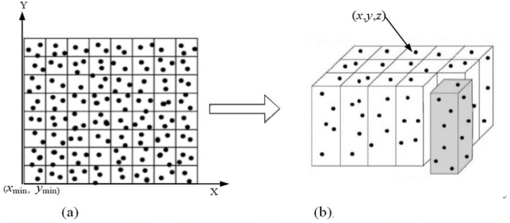
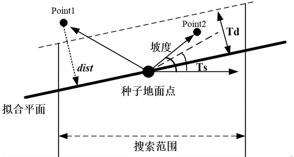
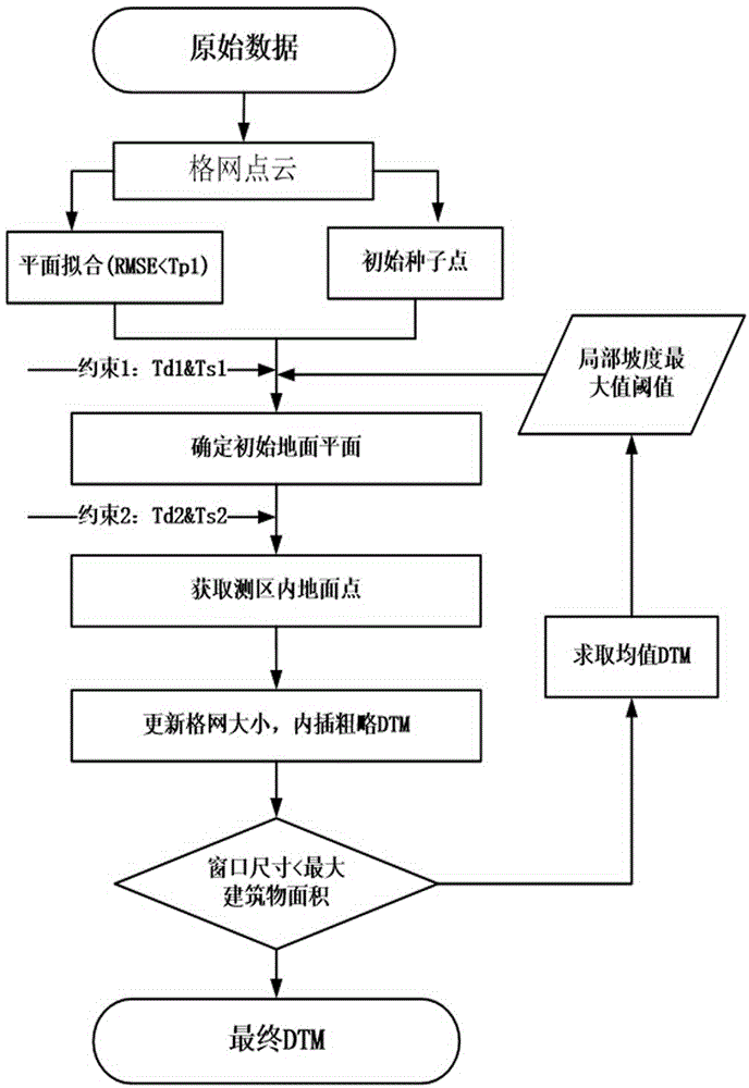
[0028] The invention proposes an adaptive gradient filtering algorithm suitable for urban classification by referring to the basic principle based on gradient filtering and fully considering point cloud data organization forms and surface forms. The slope-based filtering algorithm was first proposed by Vosselman to determine the optimal filtering function by comparing the elevation changes between two adjacent points. For a given height difference threshold Δh max (d), the decreasing distance between two points directly reduces the possibility that the laser point with a large elevation value belongs to the ground. The reason for analyzing the sudden change in elevation between two adjacent points may be that the two laser points are respectively located on the ground, vegetation, or houses, so it is based on comparing the height dif...


PUM


Abstract

The invention provides an unmanned aerial vehicle airborne LiDAR point cloud filtering method based on adaptive gradient. The method comprises the following steps: obtaining point cloud data in a test region and carrying out filtering on the point cloud data; 2) establishing index for the point cloud data; 3) carrying out calculation and keeping an optimal plane in a grid; 4) selecting an elevation lowest point in a preset window as an initial seed point of a ground point; 5) calculating the distance between the optimal plane and the ground point and gradient from the ground point to the center of the optimal plane, and obtaining a ground point set according to gradient threshold; 6) serving a point in the initial ground point set as a base point, and generating a digital terrain model through an inverse distance weighted interpolation method; and 7) through the newly-generated digital terrain model, obtaining update value of the gradient threshold, repeating the steps 4)-6) and obtaining a final ground point set. The filtering method based on adaptive gradient improves algorithm operation efficiency.

Description

technical field [0001] The invention belongs to the application field of new remote sensing data in remote sensing and photogrammetry, and in particular relates to the adaptive filtering of massive point cloud data during the rapid extraction process of the laser scanner carried in the unmanned aerial vehicle system when acquiring terrain, landform and other information Methods for evaluating processing and filtering quality. Background technique [0002] Since the 1980s, laser scanning technology (Light Detection And Ranging, LIDAR), as a new type of active remote sensing technology, has made a major breakthrough in the acquisition of three-dimensional spatial information. [1] . With the popularity and promotion of commercial airborne LiDAR systems, airborne LiDAR has been gradually applied to 3D city modeling [2] , the acquisition of the digital terrain model [3] , the production of true orthoimages [4,5] and many other fields. In recent years, the development of LiDA...

Claims


Application Information

Patent Timeline
Patent Type & Authority Applications(China)
IPC IPC(8): G06K9/00G06K9/62G06T5/00
CPCG06T5/002G06T2207/20012G06T2207/10032G06T2207/10028G06V20/13G06F18/217
Inventor 何培培郭贵海王新静魏冲
Owner NORTH CHINA UNIV OF WATER RESOURCES & ELECTRIC POWER
Why Eureka
Try Eureka