

Multi-source data integration method based on geographic information
A multi-source data and geographic information technology, applied in geographic information databases, electronic digital data processing, structured data retrieval, etc., can solve the problems of lack of quantitative positioning analysis of land information, lagging data update, heavy query and statistical workload, etc. Achieve the effect of improving the guarantee service ability
- Summary
- Abstract
- Description
- Claims
- Application Information
AI Technical Summary
Problems solved by technology
Method used
Image

Examples
Embodiment 1
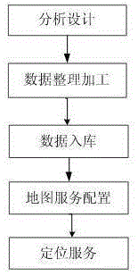
[0068] figure 1 This embodiment provides a schematic flow chart of the method for multi-source data integration based on geographic information, such as figure 1 As shown, a method for multi-source data integration based on geographic information includes the following steps:
[0069] 1. Analysis and design: conduct research on the required data, generate data analysis reports, perform basic design on the data to be processed on the basis of data demand reports, propose technical requirements for data integration and processing, and complete data analysis and design;
[0070] 2. Data sorting and processing: Integrate and process the analyzed and designed data, and integrate the business data, land parcel data and essential data, and check whether the merged data information conforms to the land plan and the current status of the land information Perform a reasonable analysis and automatically generate an analysis report of the plot information;
[0071] 3. Data storage: The results o...
Embodiment 2
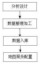
[0138] figure 2 This embodiment provides a schematic flow chart of the method for multi-source data integration based on geographic information, such as figure 2 As shown, a method for multi-source data integration based on geographic information includes the following steps:
[0139] 1. Analysis and design: conduct research on the required data, generate data analysis reports, perform basic design on the data to be processed on the basis of data demand reports, propose technical requirements for data integration and processing, and complete data analysis and design;
[0140] 2. Data sorting and processing: integrating and processing the data after analysis and design;
[0141] 3. Data storage: The results of data processing are classified and integrated into the database to form a core database. The core database includes spatial databases and non-spatial databases, including structured data and unstructured databases;
[0142] Fourth, map service configuration: the spatial data is ...
PUM
 Abstract
Description
Claims
Application Information