Airborne LIDAR air strips overlay region redundancy identification and elimination method

A technology of overlapping areas and overlapping areas, applied in radio wave measurement systems, instruments, etc., can solve the problems of reduced accuracy of de-redundancy results, failure to eliminate system errors, quantitative evaluation of the effectiveness of de-redundancy algorithms, etc., to improve data processing Efficiency and the effect of reducing data processing pressure

Active Publication Date: 2017-05-17
LIAONING TECHNICAL UNIVERSITY
View PDF2 Cites 14 Cited by
  • Summary
  • Abstract
  • Description
  • Claims
  • Application Information

AI Technical Summary

Problems solved by technology

However, none of the existing redundancy elimination methods that do not require track information does not consider the elimination of systematic errors in the original point cloud, which leads to a decrease in the accuracy of the redundancy elimination results
Moreover, none of the existing methods has quantitatively evaluated the effectiveness of the redundancy elimination algorithm

Method used


Image

  • Airborne LIDAR air strips overlay region redundancy identification and elimination method
  • Airborne LIDAR air strips overlay region redundancy identification and elimination method
  • Airborne LIDAR air strips overlay region redundancy identification and elimination method

Examples


specific Embodiment approach

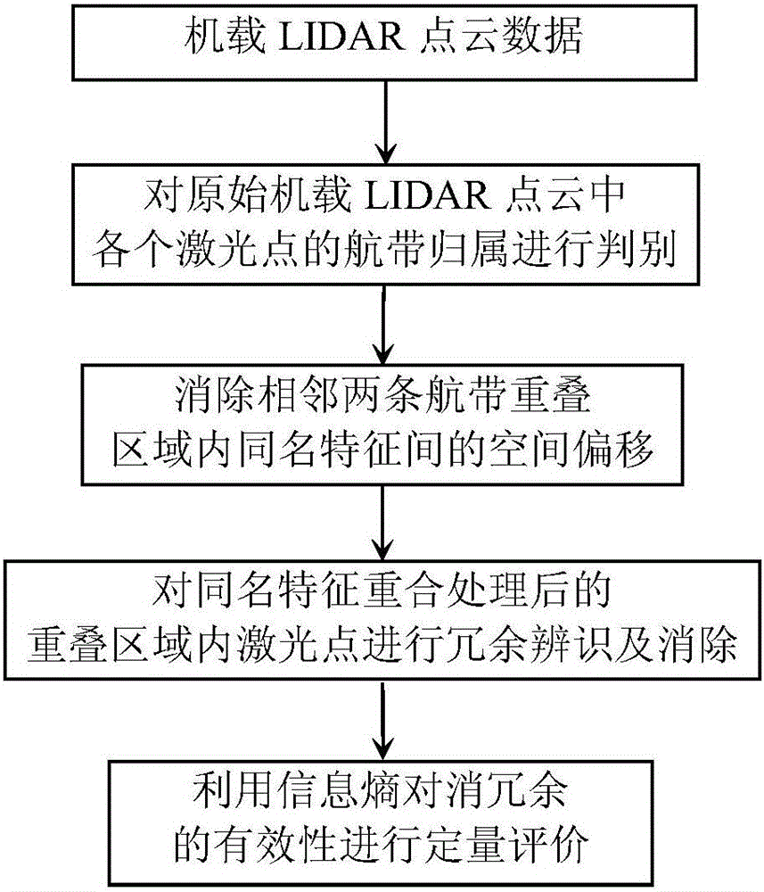
[0032] Such as figure 1 As shown, a method for identifying and eliminating redundancy in overlapping areas of airborne LIDAR flight belts includes the following steps:

[0033] Step 1: Read the original airborne LIDAR point cloud data;

[0034] Step 2: Discriminate the lane ownership of each laser point in the original airborne LIDAR point cloud, and determine the number of lanes;

[0035] Each laser point has a "GPSTime" attribute: 1) The "GPSTime" value of each laser point is unique; 2) The "GPSTime" value between two adjacent points in the same airway is uniform and continuous; 3) In the field measurement, The remote sensing platform needs to fly out of the measurement area after flying a flight strip, and then proceed to the next flight strip, so the GPSTime value between point clouds of different flight strips is quite different. In this embodiment, based on the "GPSTime" attribute of the laser point, the "GPSTime" values ​​​​of two adjacent laser points are compared, a...


PUM


Abstract

The present invention provides an airborne LIDAR air strips overlay region redundancy identification and elimination method, belonging to the remote sensing data processing technology field. The method comprises: determining the air strips to which each laser point in the airborne LIDAR point cloud belongs, and extracting an overlapping region; extracting the homonymous points in the overlapping region; calculating the conversion parameters according to the least square method, converting coordinates of the laser points of the overlapping region, and realizing the overlapping of the homonymous features; calculating a distance threshold value, and performing redundancy removal according to the laser point distance; employing the information entropy to calculate the information content of the LIDAR point cloud data in the overlapping region prior to the redundancy removal and after the redundancy removal, and performing quantitative evaluation of the redundancy removal result. The airborne LIDAR air strips overlay region redundancy identification and elimination method can effectively remove the redundant information of the overlapping region, reduce the data processing pressure, improve the efficiency, can be directly applied to the redundancy elimination of the ground and between the data of the vehicle-mounted LIDAR adjacent observation stations; adaptively obtaining the distance threshold values, determining whether the laser point has redundancy or not, making the selection rule of the data points, and realizing the rejecting of the redundancy laser point; and providing the information entropy measurement of evaluating the redundancy validity.

Description

technical field [0001] The invention belongs to the technical field of remote sensing data processing, and in particular relates to a method for identifying and eliminating redundancy in overlapping areas of airborne LIDAR flight belts. Background technique [0002] Limited by flight height and scanning field of view, the airborne LiDAR (Light Detection and Ranging, LIDAR) system can only cover a certain width of area for each flight strip scanning. In order to achieve large-area data collection, it is necessary to fly multiple flight strips with a 10%-20% lateral overlap between adjacent flight strips to completely cover the area to be measured. The second scan of the overlapping area of ​​the air strips or repeated sampling of the original laser point or sampling of a new laser point. Among them, the former generates redundant data, leading to an increase in data volume, thereby reducing data processing efficiency. In order to obtain point cloud data with a relatively un...

Claims


Application Information

Patent Timeline
Patent Type & Authority Applications(China)
IPC IPC(8): G01S7/497
CPCG01S7/497
Inventor 王丽英徐辛超张正鹏
Owner LIAONING TECHNICAL UNIVERSITY
Why Eureka
Try Eureka