Wave and sea level measuring method for deep sea and high sea based on satellite-based differential enhanced technology

A tide level and wave technology, applied in measuring devices, measuring the depth of open-air water sources, surveying and navigation, etc., can solve the natural internal relationship between split waves and tide levels, cannot jointly measure wave and tide level data, and is not suitable for deep sea tide level measurement, etc. problems, to achieve the effect of high cost performance, long measurement time and reliable measurement

Inactive Publication Date: 2017-06-13
NAT CENT OF OCEAN STANDARDS & METROLOGY
View PDF4 Cites 7 Cited by
  • Summary
  • Abstract
  • Description
  • Claims
  • Application Information

AI Technical Summary

Problems solved by technology

The former requires the cooperation of tide wells at coastal stations for measurement, while the latter is limited by the short cable length, so both have shortcomings, and neither is suitable for tide level measurement in deep and open seas
[0006] At the same time, the existing wave and tide level measurements are carried out independently, and it is impossible to jointly measure wave and tide level data. There is a problem of data fusion difficulties, which artificially separates the natural internal relationship between waves and tide levels.

Method used


Image

  • Wave and sea level measuring method for deep sea and high sea based on satellite-based differential enhanced technology
  • Wave and sea level measuring method for deep sea and high sea based on satellite-based differential enhanced technology
  • Wave and sea level measuring method for deep sea and high sea based on satellite-based differential enhanced technology

Examples


specific Embodiment approach

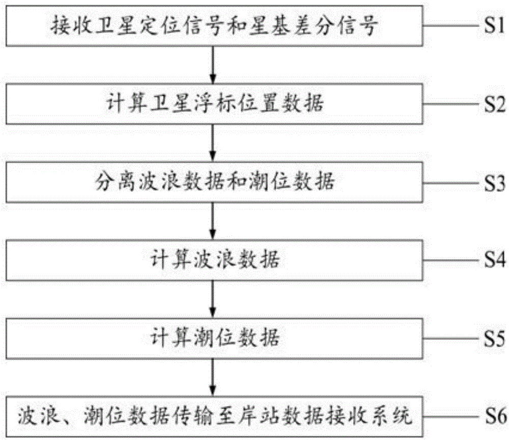
[0037] The invention utilizes satellite positioning technology and satellite-based differential enhancement technology to realize the remote on-line measurement function of deep sea wave and tide level data. The specific implementation is as follows:

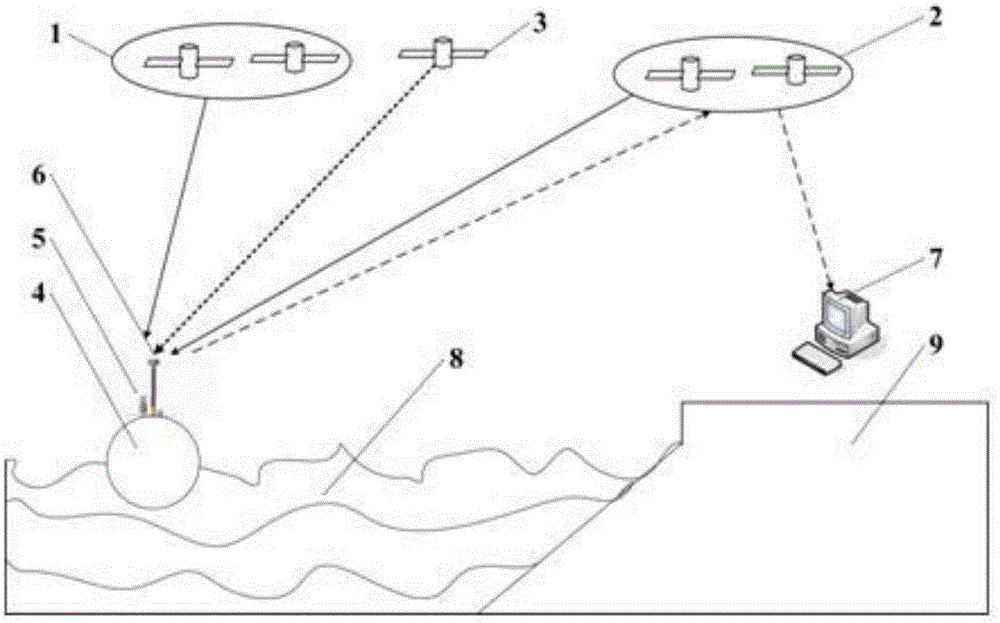
[0038] ①Satellite buoys receive satellite positioning signals and satellite-based differential signals

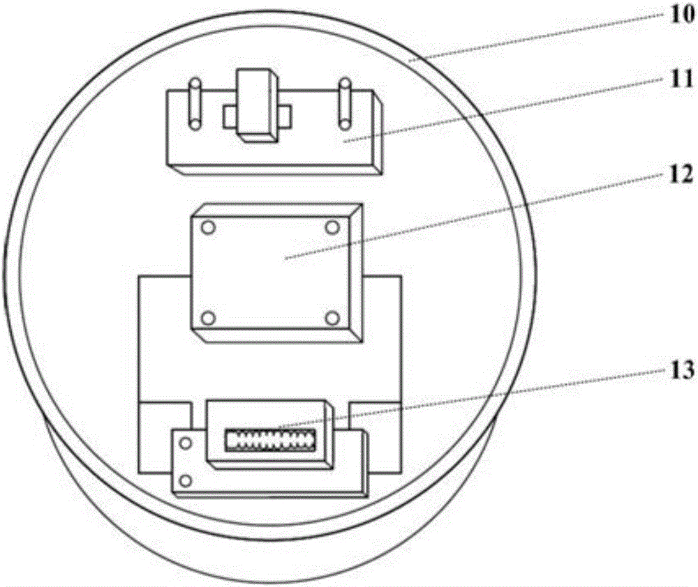
[0039] The satellite buoy 4 consists of two parts, a lower shell part 10 and an upper shell part 14 . Main components of the lower case: data calculation / sending module 11, high-energy lithium battery 12, and terminal 13. The main components of the upper shell: satellite buoy switch 5, satellite antenna 6, solar panel 15.

[0040] Satellite positioning signals are transmitted by Beidou positioning satellites and GPS positioning satellites, including Beidou satellite space coordinate values ​​(x B ,y B ,z B ) and GPS satellite spatial coordinates (x G ,y G ,z G ), these data can be accurately obtained through precise e...


PUM


Abstract

The invention discloses a wave and sea level measuring method for deep sea and high sea based on a satellite-based differential enhanced technology. By taking a Beidou system as a primary platform which is matched with a GPS (Global Positioning System), a fused localization method is formed by adopting the satellite-based differential enhanced technology, so that wave and sea level measuring work of deep sea and high sea in a global range is realized. The method comprises the following technical steps of: receiving a satellite positioning signal and a satellite-based differential signal; calculating three-dimensional position data of a satellite float; separating wave data and sea level data; calculating the wave data; calculating the sea level data; and transmitting the wave data and sea level data to a shore station data receiving system. By mounting a Beidou/GPS satellite positioning receiving card board and a satellite-based differential signal receiving module, waves and sea levels in the deep sea and high sea in the global range can be measured. The method has the characteristics of being high in measuring precision, far in working distance, wide in coverage, long in cruising duration and the like.

Description

technical field [0001] The invention relates to a method for measuring sea waves and tide levels, in particular to a method for measuring sea waves and tide levels using a Beidou system and satellite buoys. Background technique [0002] Ocean wave data and tide level data are important elements of ocean hydrological observation, mainly including wave height, wave period, wave direction and tide level. The precise measurement and forecasting of waves and tide levels in deep seas is of great significance to ocean shipping, scientific research, disaster prevention and mitigation, and national defense and military affairs. . my country has a huge demand for wave and tide level measuring instruments and equipment suitable for deep and open seas. [0003] The wave buoy is an important device for measuring wave data, and the tide gauge is an important device for measuring tide data. [0004] Wave buoys measure wave data. According to different working principles, they can be mai...

Claims


Application Information

Patent Timeline
Patent Type & Authority Applications(China)
IPC IPC(8): G01C13/00G01F23/76
CPCG01C13/00G01C13/008G01F23/76
Inventor 边鸣秋高占科贾伟广常双程绍华沈飞飞于建清朱丽萍于惠莉秦鑫培
Owner NAT CENT OF OCEAN STANDARDS & METROLOGY
Why Eureka
Try Eureka