Crop yield remote sensing estimating method and system
A crop yield and remote sensing technology, applied in computing, computer components, instruments, etc., can solve the problems of insufficient yield estimation efficiency and precision, and achieve high universality, high precision and universality
- Summary
- Abstract
- Description
- Claims
- Application Information
AI Technical Summary
Problems solved by technology
Method used
Image

Examples
Embodiment 1
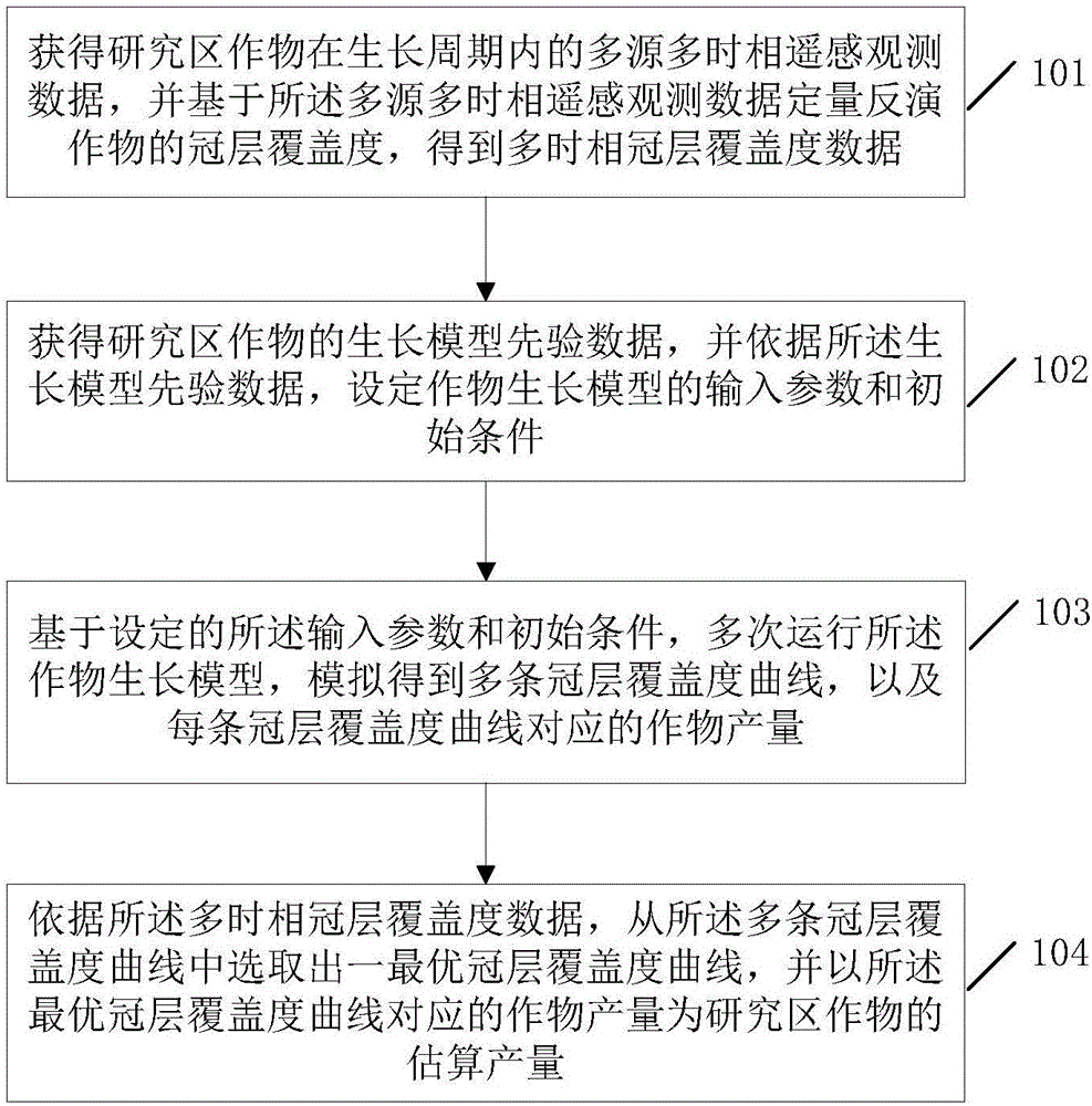
[0047] This embodiment 1 provides a crop yield remote sensing estimation method, which is used to provide basic theoretical guidance and technical method support for timely, rapid, high-precision and high universal remote sensing quantitative estimation of regional crop yield.
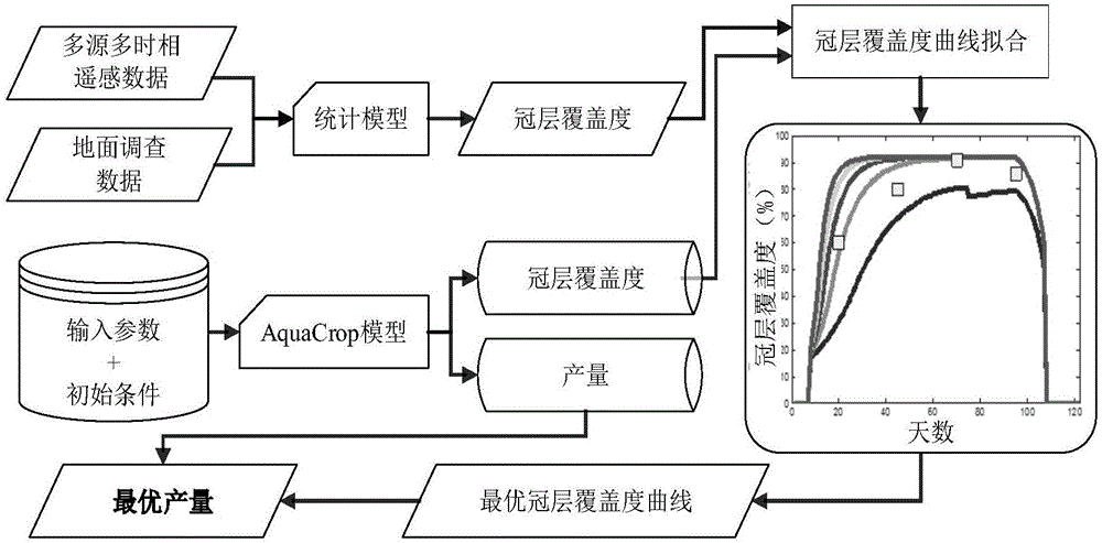
[0048] In order to meet the realistic application requirements of crop remote sensing yield estimation for high efficiency, high precision and high universality, the present invention introduces a strong mechanism and required input on the basis of analyzing the existing research on crop yield remote sensing quantitative estimation based on crop growth models. The new crop growth model AquaCrop with fewer parameters simulates the crop growth process, and replaces the leaf area index or biomass with more efficient and high-precision canopy coverage in remote sensing quantitative inversion, as the AquaCrop model and multi-source multi-time The key parameters of the link between phase remote sensing observ...
Embodiment 2
[0077] The second embodiment provides a specific application example of the crop yield remote sensing estimation method of the present invention.
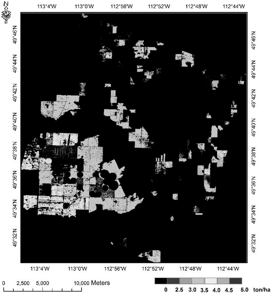
[0078] In this example, taking the multi-source and multi-temporal multi-spectral remote sensing images SPOT and RapidEye as examples, the experiment of crop yield remote sensing quantitative estimation of wheat and rapeseed in the research area was carried out. The multi-temporal remote sensing image sequence was acquired in 2013. The multi-temporal remote sensing image sequence includes: one scene of SPOT image on June 27, one scene of RapidEye image on July 2, one scene of RapidEye image on July 19, one scene of SPOT image on July 21, one scene of July 26 SPOT image, one RapidEye image on August 4th, one RapidEye image on August 7th, one SPOT image and one RapidEye image on August 17th. On this basis, using the above multi-temporal remote sensing observation data, and based on the technical solution of the present invention, the...
Embodiment 3
[0081] Embodiment 3 of the present invention provides a crop yield remote sensing estimation system, refer to Figure 4 The structure diagram of the crop yield remote sensing estimation system shown, the system may include:
[0082] The inversion unit 41 is used to obtain multi-source and multi-temporal remote sensing observation data of crops in the study area during the growth cycle, and quantitatively invert the canopy coverage of crops based on the multi-source and multi-temporal remote sensing observation data to obtain multi-temporal canopy Coverage data; setting unit 42, used to obtain the growth model prior data of the crops in the research area, and according to the growth model prior data, set the input parameters and initial conditions of the crop growth model; simulation unit 43, for Based on the set input parameters and initial conditions, the crop growth model is run multiple times to simulate multiple canopy coverage curves and the crop yield corresponding to ea...
PUM
 Abstract
Description
Claims
Application Information