Land-resource-supervision-based mobile law enforcement management system

A technology of land resources and mobile law enforcement, applied in data processing applications, instruments, calculations, etc., can solve the problems of heavy query and statistical workload, low efficiency, and high labor costs, and achieve the effect of promoting exchange and sharing and improving work efficiency

Inactive Publication Date: 2017-06-16
星际空间(天津)科技发展有限公司
View PDF1 Cites 16 Cited by
  • Summary
  • Abstract
  • Description
  • Claims
  • Application Information

AI Technical Summary

Problems solved by technology

For example, in the process of field inspection, the function of GPS is complex, and it is impossible to judge whether the current GPS location is illegal; the clues of illegal land use are repeatedly investigated and dealt with, and there is no measure to filter the source, so the efficiency is low; Different problems; daily work data is scattered without technical space sharing, data entrances and exits are scattered, and labor costs are high; leadership decision-making information feedback is not timely, accurate, and non-standard
There are also problems such as the lack of systematic sorting of data, lagging data update, large workload and low efficiency of query statistics, lack of quantitative positioning and analysis of land information in various links, relatively backward technical means, and insufficient rapid response ability to deal with important emergencies.
[0007] At present, there is no technical solution that can effectively combine and apply cloud data processing, formula calculation and application methods through the software architecture and network as a platform for the business data information and geographic information involved in the actual application of land resources. , so that the mobile law enforcement business can be used as the starting point, the system database construction as the core, the illegal land use information resource management system can be established through the network platform and application framework, and the information resources of field law enforcement can be fully and effectively used

Method used


Image

  • Land-resource-supervision-based mobile law enforcement management system
  • Land-resource-supervision-based mobile law enforcement management system
  • Land-resource-supervision-based mobile law enforcement management system

Examples


Embodiment 1

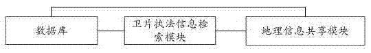
[0063] figure 1 The structural diagram of the mobile law enforcement management system based on land and resources supervision provided in this embodiment, as shown in figure 1 As shown, a mobile law enforcement management system based on land and resources monitoring, wherein the system includes a satellite image law enforcement information retrieval module, a geographic information sharing module and a database, wherein: the satellite image law enforcement information retrieval module performs field work on the data Acquisition and internal processing, complete the integration of land and resources supervision data, search, analyze and manage the law enforcement information of satellite images; the geographic information sharing module integrates the collected and processed geographic information and business data into multi-source information, providing Geographic information data service integrates geographic information operation interfaces and shares fused multi-source i...


PUM


Abstract

The invention, which belongs to the geographic information technology, discloses a land-resource-supervision-based mobile law enforcement management system comprising a satellite photo law enforcement information retrieval module, a geographic information sharing module and a database. The satellite photo law enforcement information retrieval module carries out field work collection and interior work processing on data, completes integration of land resource supervision data, and carries out retrieving, analysis and management on satellite photo law enforcement information; the geographic information sharing module caries out integration of the collected and processed geographic information with server data to form multi-source information, provides a geographic information data service, carries out integration of geographic information operation interfaces, and carries out sharing of the integrated multi-source information; and the database stores various data involved in the land resource monitoring process. The land-resource-supervision-based mobile law enforcement management system has the following advantages: with system database establishment as a core, an illegal land usage information resource management system is established by using a network platform and an application frame by starting with a mobile law enforcement service, so that information resources of field work law enforcement can be utilized effectively.

Description

technical field [0001] The present invention relates to the technical field of geographic information, specifically, an effective combination and application of business data information and geographic information involved in the actual application of land resources through software architecture, cloud data processing, formula calculation and application methods, A mobile law enforcement management system based on land and resources supervision that can achieve intelligent information transmission that can integrate data processing, analysis, application and display. Background technique [0002] There are two understandings of smart city, narrow sense and broad sense. In a narrow sense, a smart city refers to a city based on the Internet of Things, through the interconnection of things, interconnection, and intelligence, so that various functions in the city can be coordinated with each other, with a high degree of integration of smart technology, high-end development of ...

Claims


Application Information

Patent Timeline
Patent Type & Authority Applications(China)
IPC IPC(8): G06Q50/26
CPCG06Q50/26
Inventor 王力杨文博毛继国王贺朋占倩倩
Owner 星际空间(天津)科技发展有限公司
Why Eureka
Try Eureka