Environment data sharing platform, unmanned aerial vehicle and positioning method and system

A technology for unmanned aerial vehicles and environmental data, applied in satellite radio beacon positioning systems, radio wave measurement systems, instruments, etc. Problems such as poor positioning, to achieve the effect of improving accuracy and reliability

Pending Publication Date: 2017-07-07
高域(北京)智能科技研究院有限公司
View PDF2 Cites 35 Cited by
  • Summary
  • Abstract
  • Description
  • Claims
  • Application Information

AI Technical Summary

Problems solved by technology

This patent document builds an experimental platform for the vision control system of a four-rotor UAV. The platform adopts an embedded control system architecture and uses an onboard embedded computer to run the algorithm proposed in the paper. The requirements for processing power and computing power are higher, but the positioning accuracy and timeliness obtained cannot meet the flight control needs of unmanned aerial vehicles
[0013] Therefore, as described in the background technology above, when traditional unmanned aerial vehicles use visual positioning methods to solve indoor positioning problems, although they can achieve certain results, due to the lack of data support for unknown indoor environments, indoor positioning problems cannot be solved well. , even if the visual positioning method is used for positioning, the effect is not good

Method used


Image

  • Environment data sharing platform, unmanned aerial vehicle and positioning method and system
  • Environment data sharing platform, unmanned aerial vehicle and positioning method and system
  • Environment data sharing platform, unmanned aerial vehicle and positioning method and system

Examples


Embodiment 1

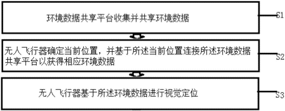
[0059] For the convenience of description, a simpler implementation is described as follows:

[0060] Although the aforementioned SLAM method was used as an example to illustrate the environmental data sharing platform 1, since the SLAM method has higher requirements on the data calculation and processing capabilities of the UAV 2, it is more widely used in UAVs with stronger performance. For some more portable and foolish Selfie UAVs, in fact, the indoor environment data sharing mode with a lower data volume can also be used, such as using a single camera facing a specific direction set on the Selfie UAV. The corresponding data is collected, so as to establish the corresponding environmental data of the indoor environment. For example, if the specific direction is facing directly downward, then the UAV can actually obtain the ground texture environment data of the entire indoor environment. For some specific indoor occasions, its ground texture has a relatively obvious degree...

Embodiment 2

[0064] For a more complicated SLAM situation, the visual recognition positioning scheme in which a pair of binocular vision depth cameras are respectively installed in front and below the unmanned aerial vehicle is illustrated as an example.

[0065] Since the depth of field is obtained through a pair of binocular vision depth cameras, the current unmanned aerial vehicle can actually achieve visual obstacle avoidance in the forward and downward directions where the camera is installed, allowing the unmanned aerial vehicle to avoid this direction. of obstacles. However, since these data are obtained in real time and processed in real time to judge whether there are obstacles in real time, without the accumulation of historical data, the results of data collection cannot improve the efficiency of use through repeated accumulation. In the solution of this application, the video data continuously collected by the depth camera is continuously stored, and the data captured by the fo...

Embodiment 3

[0070] If it is based on a specific aircraft itself to collect corresponding environmental data during the user's flight, and to improve the positioning effect of the aircraft in indoor flight by continuously improving the environmental data, then this solution is commercially unrealistic. Because the effect is not good, and the price paid is relatively high.

[0071] This application emphasizes that a large amount of environmental data in different places is accumulated in the early stage through the individual use behaviors of a large number of different users.

[0072] At the very beginning, it may be necessary to actively use unmanned aerial vehicles to actively collect environmental data in some commonly used indoor flying sites through the platform operator, but more importantly, encourage users to fly in different indoors through various methods sites and attempt to collect historical environmental data generated by these users that may be wasted or ignored.

[0073] W...


PUM


Abstract

The invention discloses a positioning method and system of an unmanned aerial vehicle capable of sharing environment data, an environment data sharing platform and the unmanned aerial vehicle. The positioning method includes the following steps that the environment data sharing platform (1) collects and shares environment data; the unmanned aerial vehicle (2) conducts visual positioning on the basis of the environment data. The positioning system comprises the environment data sharing platform (1) capable of collecting and sharing the environment data, and the unmanned aerial vehicle (2); the environment data sharing platform (1) comprises a storage device (3) and a communication port (4), the storage device (3) saves a database of the environment data, and the communication port (4) is used for having access to the database and is in wireless communication connection with the unmanned aerial vehicle (2). The unmanned aerial vehicle (2) comprises a communication device (5) for receiving the environment data, a processor (6) for processing the environment data and a camera and / or a laser radar (7) used for visual positioning, and the unmanned aerial vehicle (2) conducts visual positioning through the camera and / or the laser radar (7) on the basis of the environment data.

Description

technical field [0001] The invention belongs to the field of unmanned aerial vehicles, and in particular relates to an unmanned aerial vehicle positioning method, a positioning system, an environmental data sharing platform and an unmanned aerial vehicle for indoor sharing of environmental data without a GPS signal. Background technique [0002] At present, it is mainly based on GPS. GPS is used here as an example to illustrate the satellite positioning and navigation system. In fact, there are similar systems in Russia and China in the world. Since their specific principles and conditions are not directly related to the technical solution of this application, here No more explanations, or the positioning problem of outdoor UAVs realized by differential GPS has been basically solved. Due to the increasing efficiency of the use of GPS signals, better UAVs flying outdoors have already used GPS signals. Position recognition at the centimeter level can be easily achieved. Speci...

Claims


Application Information

Patent Timeline
Patent Type & Authority Applications(China)
IPC IPC(8): G01C21/00G01C21/20G01S17/02G01S17/88G01S19/45
CPCG01C21/005G01C21/206G01S17/86G01S17/88G01S19/45
Inventor 不公告发明人
Owner 高域(北京)智能科技研究院有限公司
Why Eureka
Try Eureka