Highway topographic map surveying and mapping method and highway topographic map surveying and mapping system based on on-board and airborne point cloud

A technology for topographic maps and highways, applied in the field of surveying and mapping engineering, can solve problems such as insufficient bandwidth, insufficient accuracy, and limited surveying and mapping areas, and achieve the effects of reducing work costs, improving work efficiency, and overcoming low efficiency.

Pending Publication Date: 2017-08-18
BROADVISION ENG CONSULTANTS
View PDF3 Cites 32 Cited by
  • Summary
  • Abstract
  • Description
  • Claims
  • Application Information

AI Technical Summary

Problems solved by technology

Vehicle-mounted lidar surveying and mapping technology is mainly limited by the area of ​​the data collection area and road traffic capacity. Although the density and accuracy of the point cloud produced by it are high, but when applied to actual projects, there are problems such as insufficient bandwidth and restrictions on the surveying and mapping area.
In other words, there must be roads where vehicles can pass in the area to be collected, and the line of sight cannot be completely blocked
Although the UAV oblique photography technology has a large surveying and mapping area, there are problems such as complex calculations in the later stage, insufficient precision, and low accuracy.
Up to now, no one has taken advantage of the advantages and disadvantages of these two technologies to effectively combine the two to improve work efficiency and solve practical work problems while meeting the accuracy requirements, bandwidth requirements, and ease of operation, so as to meet the actual requirements. Demand for road surveying and mapping work

Method used


Image

  • Highway topographic map surveying and mapping method and highway topographic map surveying and mapping system based on on-board and airborne point cloud
  • Highway topographic map surveying and mapping method and highway topographic map surveying and mapping system based on on-board and airborne point cloud
  • Highway topographic map surveying and mapping method and highway topographic map surveying and mapping system based on on-board and airborne point cloud

Examples


Embodiment 1

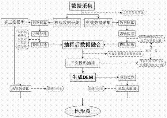
[0036] Such as figure 1 As shown, a kind of road topographic map surveying and mapping method based on vehicle-mounted and airborne point cloud that this embodiment relates to comprises the following steps:

[0037] (1) Use the vehicle-mounted scanning system to collect high-density 3D vector point cloud data on the road, specifically including the following steps: A. Set up a base station at a known control point with better satellite signals; B. Debug the configuration of the vehicle-mounted mobile station and adjust the position of the vehicle body ; C. Through the integrated laser monitoring and scanning car, the data acquisition system collects high-density 3D point clouds during the high-speed movement of the car body to ensure the accuracy and availability of the collected data. The purpose of setting up the base station is to correct the error of the GPS signal observed by the mobile station through the GPS signal observed by the fixed base station. Before data collec...

Embodiment 2

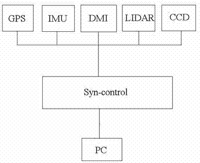
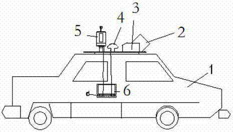
[0046] Such as Figure 2-5 As shown, the road topographic mapping system based on vehicle-mounted and airborne point clouds used in Embodiment 1 is realized, including: a laser monitoring and scanning vehicle, an unmanned aerial vehicle and a data processing system. The laser monitoring and scanning vehicle includes a car body 1, a The laser scanner 2 on the top of the car body, the inertial navigation system (IMU) 3, the vehicle GPS 4, the wheel encoder (DMI), and the image acquisition system (CCD) 5, wherein the GPS is set on the top of the car body.

[0047] Such as figure 2 As shown, the signals of GPS, laser scanner (LIDAR), inertial navigation system (IMU), wheel encoder (DMI), image acquisition system (CCD) and panoramic camera enter the synchronous controller (Syn-control), and then Collected and stored by the computer (pc) in the car.

[0048] Such as Figure 4 As shown, the unmanned aerial vehicle includes a five-lens tilting camera 8, a flight control system 7, ...


PUM


Abstract

The invention relates to a highway topographic map surveying and mapping method and a highway topographic map surveying and mapping system based on on-board and airborne point cloud, and belongs to the surveying and mapping engineering field. By adopting the highway topographic map surveying and mapping method, two emerging technologies, namely, an on-board laser radar surveying and mapping technology and an unmanned aerial vehicle oblique photography surveying and mapping technology, are effectively combined with each other. The working efficiency of the highway engineering terrain surveying and mapping is improved, the working costs thereof are reduced, and topographic map surveying and mapping result precision is improved, and in addition, defects of conventional ways such as low efficiency, high risks, long cycle length, and poor timeliness are overcome, and therefore certain social benefits and economic benefits are provided.

Description

technical field [0001] The present invention relates to a road topographic map surveying and mapping method, in particular to a highway topographic map surveying and mapping method based on vehicle-mounted and airborne point cloud fusion, and also relates to a road topographic map surveying and mapping system based on vehicle-mounted and airborne point cloud fusion, which belongs to surveying and mapping engineering field. Background technique [0002] With the advancement of the transportation construction during the 13th Five-Year Plan, the road surveying work is facing the pressure of time constraints and heavy tasks, and a large number of construction projects require topographic map surveying and mapping along the line. [0003] Traditional surveying and mapping methods mainly include aerial photogrammetry mapping, satellite stereoscopic mapping and full-field digital mapping methods. The former two belong to the area acquisition method, and the latter belongs to the si...

Claims


Application Information

Patent Timeline
Patent Type & Authority Applications(China)
IPC IPC(8): G01S17/88G01C11/04
CPCG01C11/04G01S17/88
Inventor 王开洋方留杨吴晓南马力王斌苏宇潘俊良赵鑫余相贵陈贺叶咸郭彪
Owner BROADVISION ENG CONSULTANTS
Why Eureka
Try Eureka