Multi-rotor-wing-unmanned-aerial-vehicle atmosphere pollution detection system and method
A multi-rotor unmanned aerial vehicle and detection system technology, applied in the field of multi-rotor unmanned aerial vehicle air pollution detection system, can solve the problems of limited site coverage, large satellite remote sensing coverage, lack of near-ground vertical distribution detection data, etc. Significant, low-cost effects
- Summary
- Abstract
- Description
- Claims
- Application Information
AI Technical Summary
Problems solved by technology
Method used
Image
Examples
Embodiment 1
[0051] In order to solve the above technical problems, the present invention discloses the following technical solutions:
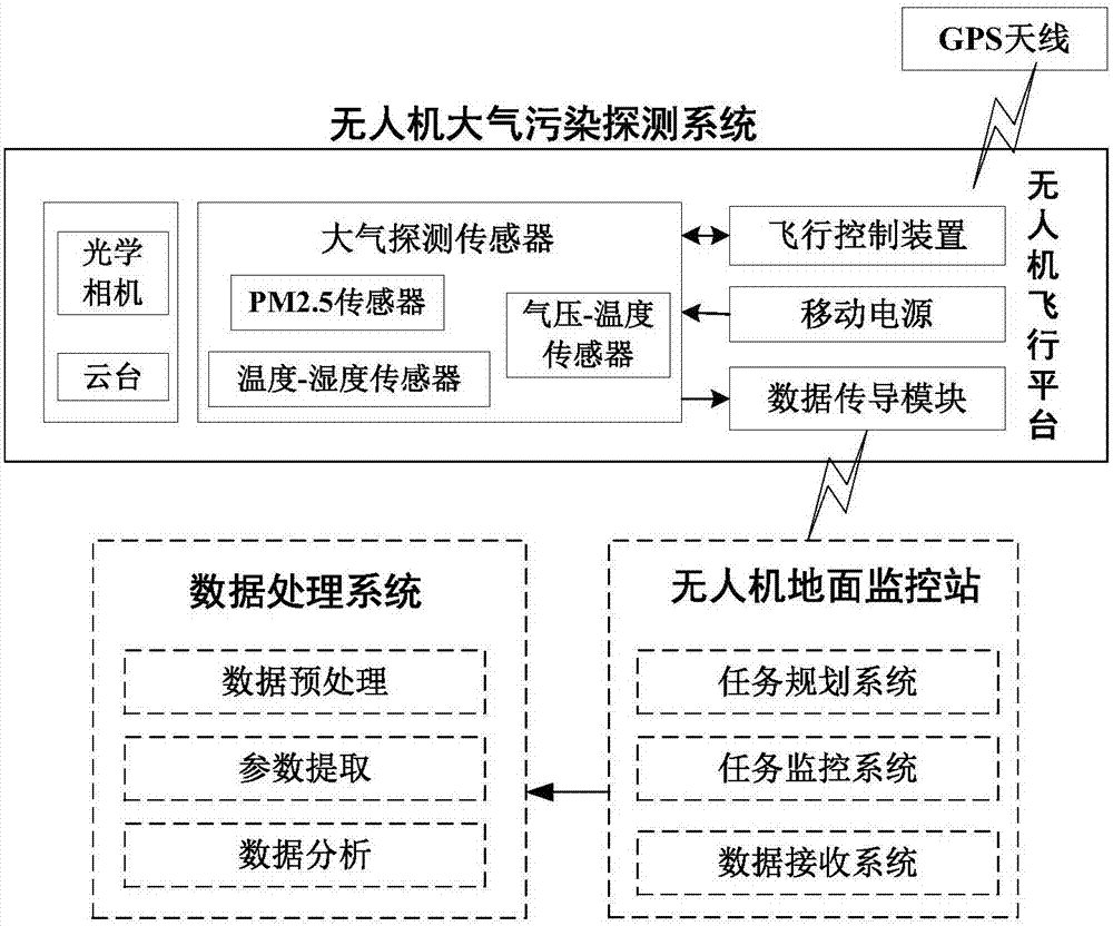
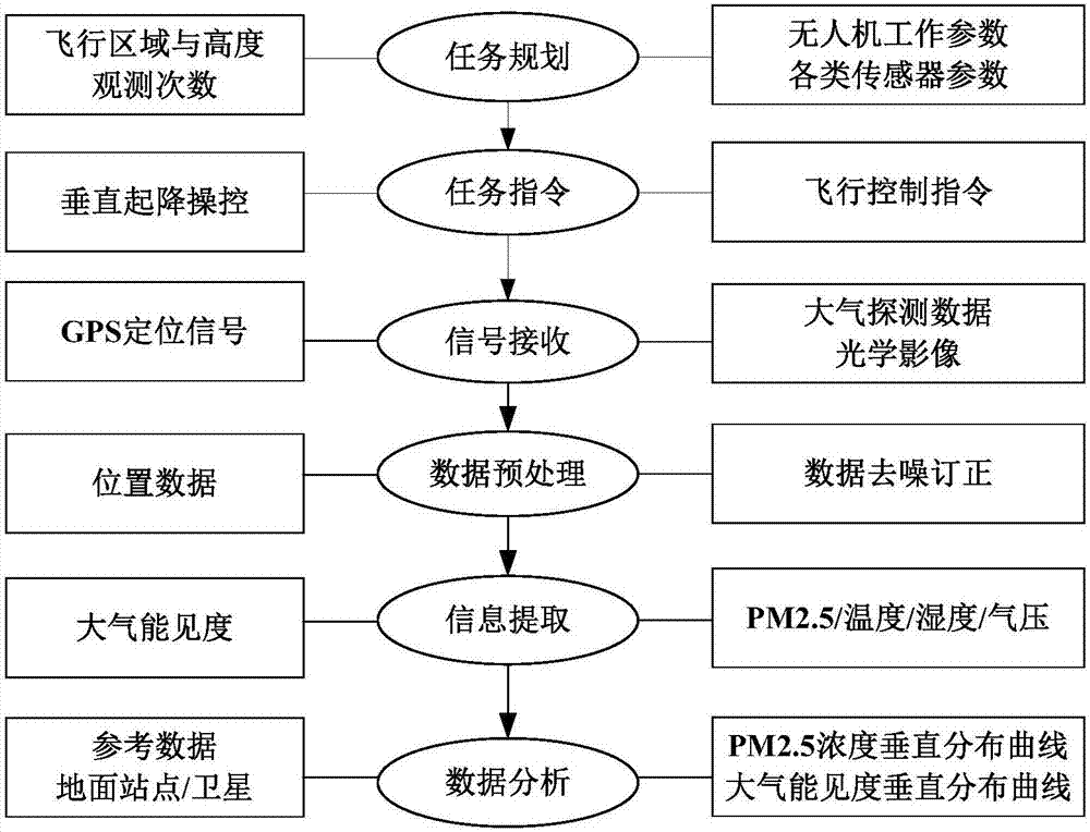
[0052] In the first aspect, a multi-rotor UAV air pollution detection system is provided. The system consists of a multi-rotor UAV flight platform subsystem, a light and small sensor group, a data wireless transmission device, and a ground monitoring station, which is the UAV ground monitoring subsystem. The system and data processing software are data processing subsystems, which are used to obtain the vertical distribution data of low-altitude PM2.5 and related atmospheric parameters. The system includes:
[0053] Step 1) The subsystem of the multi-rotor UAV flight platform includes a power system, a bracket, a fuselage, a GPS positioning device, and a remote control. The propulsion system is equipped with a helical wing with 6 motors; the six-rotor UAV flight platform has a take-off weight of 6.0kg, a payload of 2.3kg, a ceiling of 200m, and a flight ...
Embodiment 2
[0074] The embodiment of the invention discloses the following technical solutions:
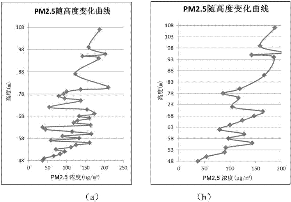
[0075] The embodiment is an observation instance carried out at the Beijing Olympic Sports Center in April 2015 using the system developed by the present invention. Six voyage detections were carried out at 14:30-16:00 on 3 / 17 / 24 respectively. The monitoring site of the Olympic Sports Center of the environmental monitoring station can provide comparison data for the example. Taking the observation on April 3 as an example, an example of data processing and analysis results is given.
[0076] Step (1): An example of observation data obtained after data preprocessing using the received UAV detection data;
[0077] Example of observation data on April 3, 2015
[0078]
[0079] Corrected PM2.5 height interval 2m average data
[0080] high
48
50
52
54
56
58
60
62
64
66
68
70
48
PM2.5
37
54
90
92
144
97
128
80
...
PUM
 Abstract
Description
Claims
Application Information
 - R&D
- Intellectual Property
- Life Sciences
- Materials
- Tech Scout
- Unparalleled Data Quality
- Higher Quality Content
- 60% Fewer Hallucinations
Browse by: Latest US Patents, China's latest patents, Technical Efficacy Thesaurus, Application Domain, Technology Topic, Popular Technical Reports.
© 2025 PatSnap. All rights reserved.Legal|Privacy policy|Modern Slavery Act Transparency Statement|Sitemap|About US| Contact US: help@patsnap.com


