Unmanned vehicle navigation and positioning precision correction method based on GNSS and visual odometry fusion

A visual odometry and positioning accuracy technology, applied in the field of unmanned vehicle integrated navigation, can solve the problems of high price, low accuracy and poor reliability of the integrated navigation system, and achieve the optimization of positioning accuracy, improve positioning accuracy, and suppress drift errors. Effect

Inactive Publication Date: 2017-10-03
CHERY AUTOMOBILE CO LTD
View PDF9 Cites 33 Cited by
  • Summary
  • Abstract
  • Description
  • Claims
  • Application Information

AI Technical Summary

Problems solved by technology

[0004] In view of the above existing technical problems, the purpose of the present invention is to propose a method for correcting the navigation positioning accuracy of...

Method used


Image

  • Unmanned vehicle navigation and positioning precision correction method based on GNSS and visual odometry fusion
  • Unmanned vehicle navigation and positioning precision correction method based on GNSS and visual odometry fusion
  • Unmanned vehicle navigation and positioning precision correction method based on GNSS and visual odometry fusion

Examples


Embodiment Construction

[0031] The present invention will be described in detail below according to the accompanying drawings, which is a preferred embodiment among various implementations of the present invention.

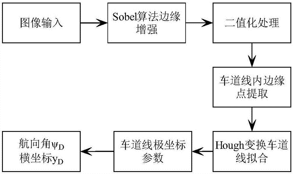
[0032] (1) Lane line detection based on monocular vision

[0033] Read a frame of image and process the image line by line. For each line in the image, the Sobel algorithm sensitive to the horizontal direction is firstly used to enhance the edge. Then the line information is processed and binarized, and the inner edge extraction algorithm of the lane line is used for the binarized data to extract the inner edge points of the lane line, and the hough transform is used to fit the lane line to obtain the polar coordinate parameters of the lane line (polar coordinate radius and angle). Extract the heading angle ψ of the vehicle in the road coordinate system D and lateral position y D . The lane line detection process is as follows: figure 1 shown.

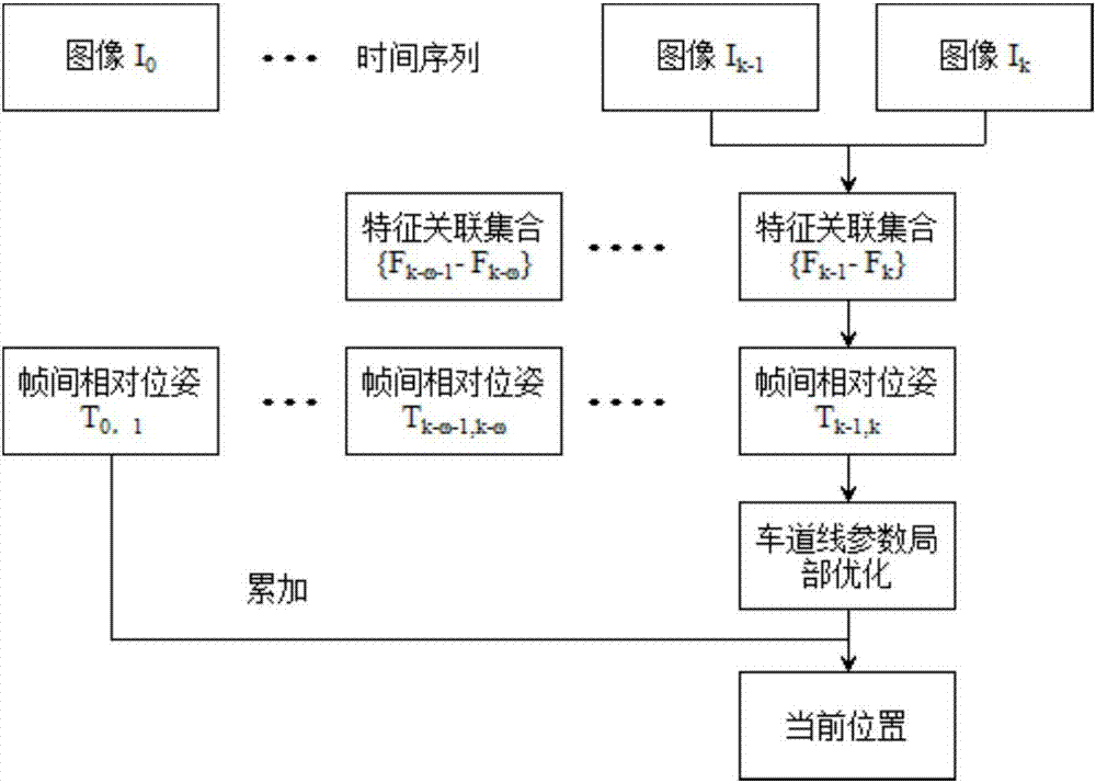
[0034] (2) Optimization of position...


PUM


Abstract

The invention relates to an unmanned vehicle navigation and positioning precision correction method based on GNSS and visual odometer fusion. The unmanned vehicle navigation and positioning precision correction method comprises the steps of: (1) detecting lane lines based on monocular vision; (2) optimizing positioning precision of a monocular visual odometer; (3) and correcting positioning precision of a GNSS/VO integrated navigation system. The unmanned vehicle navigation and positioning precision correction method utilizes the lane lines for assisting the visual odometer, then fusing the visual odometer with GNSS positioning to improve the reliability of a vehicle positioning system; the GNSS/VO has a high complementary feature, the GNSS can obtain a long-term stable positioning result, and VO can obtain short-term high-precision positioning data, two sensors are used for filtering a difference value of position measured values, and estimated value of VO system errors is used for correcting errors of the VO system, thereby realizing the purpose of restricting long-term drift of the VO data by utilizing the GNSS data.

Description

technical field [0001] The invention relates to the technical field of unmanned vehicle integrated navigation, in particular to a fusion navigation method based on GNSS, visual odometer, and lane line detection. Background technique [0002] With the popularity of cars and the increase in frequency of use, road congestion, environmental pollution and traffic accidents have become problems that people have to face. Developing unmanned vehicles and researching the autonomous driving system of vehicles is currently the best choice to achieve safe and efficient transportation. Positioning, as the key technology of unmanned vehicles, is an urgent problem to be solved in the current vehicle navigation system. The global satellite navigation system GNSS (GPS, GLONASS, Galileo, BeiDou) was often used in early vehicle positioning systems. GNSS can provide global, high-precision positioning services, but affected by satellite orbit errors, clock errors, and signal propagation errors...

Claims


Application Information

Patent Timeline
IPC IPC(8): G01S19/48G01C21/20
Inventor 曾庆喜冯玉鹏周倪青邓书朝李中兵
Owner CHERY AUTOMOBILE CO LTD
Why Eureka
Try Eureka