
Landslide susceptibility evaluation method based on remote-sensing image of unmanned aerial vehicle

A susceptibility, machine remote sensing technology, applied in image enhancement, image analysis, image data processing and other directions, can solve the practical reference significance of geological landslide disaster prevention and early warning in mountainous areas, the evaluation of the probability of landslide disasters, and the rough accuracy. And other issues

Inactive Publication Date: 2017-11-17
CHONGQING UNIV
View PDF2 Cites 27 Cited by
  • Summary
  • Abstract
  • Description
  • Claims
  • Application Information

AI Technical Summary

Problems solved by technology

[0003] The current mainstream landslide susceptibility assessment method can only carry out landslide hazard zoning assessment in a large area, because its accuracy is too rough to assess the susceptibility of landslide hazards in local areas within the region, so it is difficult to apply In engineering practice, it is of little practical reference significance for geological landslide disaster prevention and early warning in mountainous areas

Method used


Image

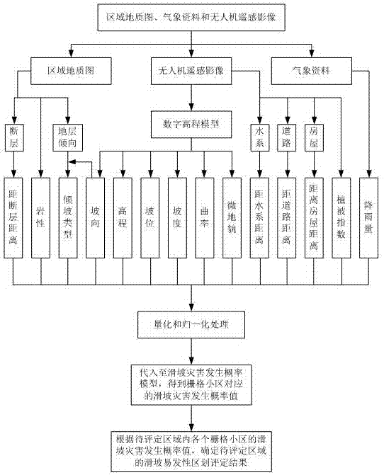
  • Landslide susceptibility evaluation method based on remote-sensing image of unmanned aerial vehicle
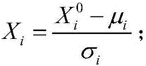
  • Landslide susceptibility evaluation method based on remote-sensing image of unmanned aerial vehicle
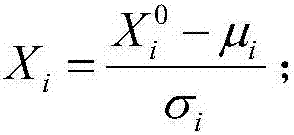
  • Landslide susceptibility evaluation method based on remote-sensing image of unmanned aerial vehicle

Examples


Embodiment Construction

[0050] In the face of the problem that the existing landslide risk assessment technology cannot accurately assess the susceptibility of landslide disasters to local areas in the region, the main reason is that the evaluation parameters used by the existing landslide risk assessment technology cover a large range , the accuracy of the coverage area is relatively rough, and it cannot reflect the difference in evaluation parameters between different local areas in the same area. In recent years, UAV technology has been applied in the field of geological exploration due to its low cost, high safety, high maneuverability and high resolution. Therefore, it can be considered to use UAVs to collect images with high resolution characteristics, take UAV images of the area to be evaluated, and extract parameters that can characterize the relevant characteristics of local landslides in the area to be evaluated in order to carry out Assessment of susceptibility to landslide hazards in loca...


PUM


Abstract

The invention provides a landslide susceptibility evaluation method based on a remote-sensing image of an unmanned aerial vehicle. According to the method, by employing the image acquired by the unmanned aerial vehicle as main characteristic data for evaluation of the landslide susceptibility and with the combination of a regional geological map and meteorological data of an evaluation object region, landslide related parameters for representing different local area landslide related characteristics in a detailed manner are comprehensively extracted as landslide susceptibility influence factors, and landslide disaster occurrence probabilities of different local areas in a to-be-evaluated region are determined by employing a landslide disaster occurrence probability model established by a logistic regression method so that a landslide susceptibility regionalization evaluation result of the to-be-evaluated region is determined, the landslide susceptibility regionalization evaluation can be accurately realized even for the to-be-evaluated regions with small overall area ranges, the evaluation results are high in local area pertinence, high in reliability, and good in practicality, and accurate and scientific data reference information can be provided for the application of landslide disaster prevention and early warning, engineering construction detection, and geological research etc.

Description

technical field [0001] The invention relates to the technical field of engineering geology and geological disaster exploration and prediction, in particular to a method for evaluating landslide susceptibility based on remote sensing images of drones. Background technique [0002] In recent years, due to the complex mountainous terrain and landforms in my country that far exceed the average mountainous area of ​​the world, coupled with the intensification of human engineering activities, extreme rainfall and earthquakes and other triggering conditions, geological disasters such as landslides, collapses, and debris flows have occurred extensively, which has given people Life and property pose a huge threat, and the livable environment deteriorates. Preventing landslides and other geological disasters has become a major problem that needs to be solved urgently to ensure a livable environment in mountainous areas. [0003] The current mainstream landslide susceptibility assessme...

Claims


Application Information

Patent Timeline
IPC IPC(8): G06Q10/04G06Q50/26G06T7/00G06T7/11G06K9/62
CPCG06Q10/04G06Q50/26G06T7/0002G06T7/11G06T2207/30181G06T2207/10032G06F18/214
Inventor 文海家薛靖元黄雪浪谢朋胡晶张岩岩
Owner CHONGQING UNIV
Learn More