Vegetation loss direction identification method based on multi-remote-sensing index trend

A technology of changing trends and identification methods, applied in the field of remote sensing information processing, can solve the problems of difficult to achieve continuous automatic monitoring, the degree of automation needs to be improved, and the lack of geographical significance, achieving clear methods, stable and reliable results, and good geographical interpretation. effect of meaning

Active Publication Date: 2017-12-12
FUZHOU UNIV
View PDF4 Cites 12 Cited by
  • Summary
  • Abstract
  • Description
  • Claims
  • Application Information

AI Technical Summary

Problems solved by technology

The disadvantage of this method is that errors in land use / cover classification have accumulated over the years, and data consistency is relatively poor, making it difficult to achieve continuous automatic monitoring over a large area for many years
With the vigorous development of land use / cover change monitoring technology based on time-series remote sensing data, the following aspects still need to be further analyzed and discussed: (1) Desertification is an important process of land use / cover change. It has received attention since then, but the technical method of making full use of time-series remote sensing data is still rare; (2) The algorithm of time-series remote sensing monitoring technology with the theme of urbanization and forest disturbance monitoring is relatively complicated, and the degree of automation needs to be improved; (3) At present, considering Change detection methods for various land use / cover change types are mostly based on data-driven models, which are difficult to reveal the change process well, and relatively lack geographical significance

Method used


Image

  • Vegetation loss direction identification method based on multi-remote-sensing index trend
  • Vegetation loss direction identification method based on multi-remote-sensing index trend
  • Vegetation loss direction identification method based on multi-remote-sensing index trend

Examples


Embodiment Construction

[0021] The technical solution of the present invention will be specifically described below in conjunction with the accompanying drawings. The following are specific embodiments of the present invention.

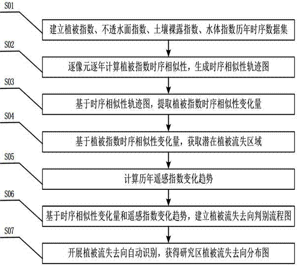
[0022] The invention provides a method for identifying vegetation loss and direction based on the changing trend of multi-remote sensing indices, such as figure 1 Shown: first establish the multi-year time-series data set of vegetation index, impervious surface index, soil exposure index, and water body index in the study area, and then determine and extract the vegetation change area based on the time-series similarity change of vegetation index, and then combine the changes of multiple remote sensing indexes Trend feature, automatic recognition of vegetation flow loss.

[0023] further comprising the following steps:

[0024] Step S01: Establish vegetation index, impermeable surface index, soil exposure index, and water body index time series data sets over the years;

...


PUM


Abstract

The present invention discloses a vegetation loss direction identification method based on a multi-remote-sensing index trend. The method comprises: calculating a temporal similarity of vegetation indexes between each year and a beginning year by using a JM distance to generate a track of temporal similarity of vegetation indexes; extracting a potential vegetation loss region according to a variation of the temporal similarity of the vegetation index, so as to define a region where the vegetation index is significantly decreased and an impervious surface index is significantly increased as a vegetation loss region; and on this basis, finally determining different vegetation loss directions such as urbanization, desertification and wetland formation according to a water body index and a bare soil index trend feature. In the method, the vegetation change region is determined by using the variation of the temporal similarity, and further, the vegetation loss direction is determined according to multiple remote sensing indexes, without depending on manual intervention for threshold setting, so that the method has the characteristics of high robustness, high classification precision, high automation and storing anti-interference ability, and so on.

Description

technical field [0001] The invention relates to the field of remote sensing information processing, in particular to an automatic identification method for vegetation loss and loss based on time series similarity variation and remote sensing index variation trend. Background technique [0002] Land use / cover change is the result of the interaction between human and nature. Over the past 30 years, with the rapid development of China's economy, land use / cover change has shown the following distinctive features: (1) urbanization, the scale of urban land use has increased, and high-quality cultivated land resources have been occupied; (2) land desertification, On the one hand, after the rural population moved to the cities, arable land was seriously abandoned; on the other hand, the ecological environment in the arid and semi-arid areas of Northwest China was relatively fragile. desertification of the area. Rapid real-time monitoring of land use / cover change is very important ...

Claims


Application Information

Patent Timeline
Patent Type & Authority Applications(China)
IPC IPC(8): G06F19/00
CPCG16Z99/00
Inventor 邱炳文张珂王壮壮
Owner FUZHOU UNIV
Why Eureka
Try Eureka