
GNSS-based differential positioning method and its positioning system

A differential positioning and positioning terminal technology, applied in the field of communication, can solve the problems of distance error from satellite to positioning terminal, the positioning error becomes larger, and the position of the positioning terminal is not unified with the real position, so as to reduce the multi-path error, improve the positioning accuracy, Guaranteed effect of stability

Active Publication Date: 2021-09-17
HUNAN GOKE MICROELECTRONICS
View PDF8 Cites 0 Cited by
  • Summary
  • Abstract
  • Description
  • Claims
  • Application Information

AI Technical Summary

Problems solved by technology

[0003] The traditional satellite positioning method adopts: according to the distance observation value from the satellite to the positioning terminal, the position of the point to be measured is calculated by using the space rear distance rendezvous principle, but because the satellite signal is interfered by various factors during the transmission process, such as The impact of ionosphere, troposphere, receiver clock error, satellite clock error, multipath, random noise, etc., makes the calculated distance from the satellite to the positioning terminal have errors, resulting in the position output by the positioning terminal not being consistent with the real position
[0004] The ionosphere, troposphere, satellite clock error, and receiver clock error all have corresponding mathematical methods that can be estimated, but the multipath error presents a certain randomness, so far there is no perfect mathematical model to estimate its size
[0005] The application number is 201710121094.1, and the patent name is "a base station equipment, terminal and positioning method". It uses window smoothing hatch filtering for positioning to reduce the influence of multipath errors, and uses the weighted least square method to obtain the positioning results. The data are all calculated independently to reduce the impact of observations with large errors. However, if the errors of observations are large at this time, the positioning error will suddenly increase at this moment.

Method used


Image

  • GNSS-based differential positioning method and its positioning system
  • GNSS-based differential positioning method and its positioning system
  • GNSS-based differential positioning method and its positioning system

Examples


Embodiment Construction

[0053] The following will clearly and completely describe the technical solutions in the embodiments of the present invention. Obviously, the described embodiments are only some of the embodiments of the present invention, rather than all the embodiments. Based on the embodiments of the present invention, all other embodiments obtained by persons of ordinary skill in the art without making creative efforts belong to the protection scope of the present invention.

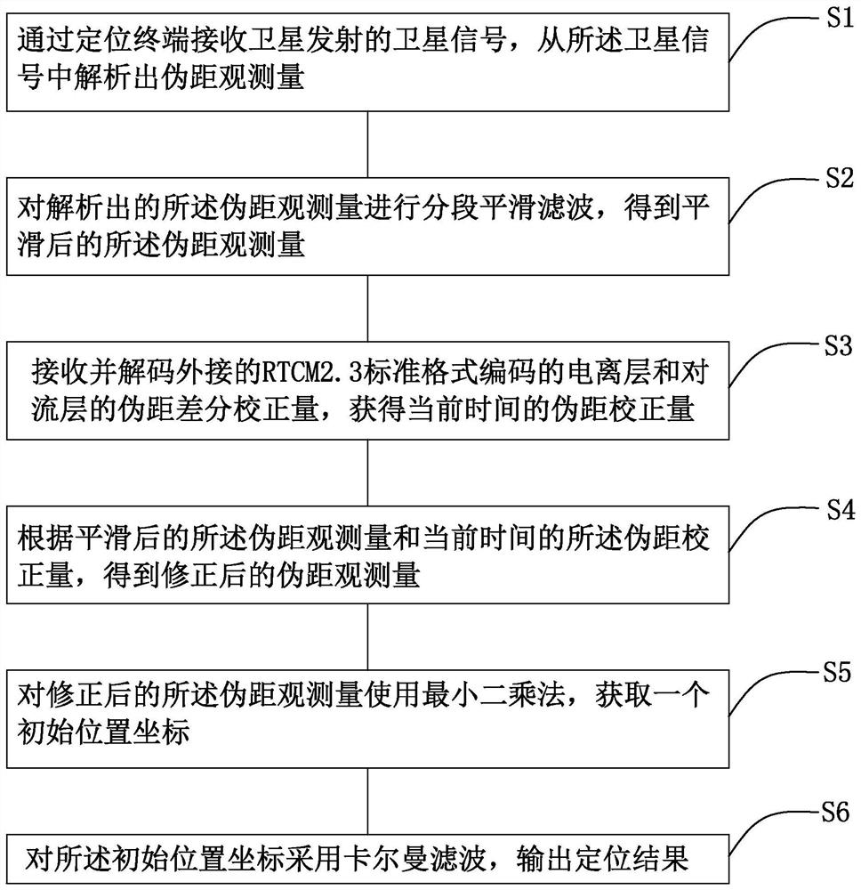
[0054] like figure 1 As shown, the present invention provides a kind of differential positioning method based on GNSS, comprises the following steps:

[0055] S1. Receive the satellite signal transmitted by the satellite through the positioning terminal, and analyze the pseudo-range observation amount from the satellite signal;

[0056] Described pseudo-range observation quantity ρ is by formula ρ=c*(t u -t s ) is calculated, where, t s is the launch time of the satellite signal, t u is the time for the position...


PUM


Abstract

The present invention provides a GNSS-based differential positioning method, comprising the following steps: S1, analysing a pseudorange observation amount from a satellite signal; S2, performing segmental smoothing filtering to obtain the smoothed pseudorange observation amount; S3, Obtaining the pseudorange correction amount at the current time; S4, obtaining the corrected pseudorange observation amount; S5, obtaining an initial position coordinate; S6, applying Kalman filtering to the initial position coordinate, and outputting a positioning result. The invention also provides a GNSS-based differential positioning system. Compared with the related art, the present invention provides a GNSS-based differential positioning method and a positioning system with the following beneficial effects: selecting an appropriate smoothing filter constant, effectively reducing multi-path errors; using segmented smoothing filtering to ensure smooth stability; The ionospheric tropospheric error is corrected by means of an external data stream; the Kalman filter is used to effectively utilize pseudorange observations to improve positioning accuracy.

Description

technical field [0001] The invention relates to the technical field of communication, in particular to a GNSS-based differential positioning method and a positioning system thereof. Background technique [0002] With the development of the Internet of Things and the advent of the sharing economy, the market demand for positioning equipment is increasing, such as products such as shared bicycles. Shared bicycles are positioned using satellite positioning terminals. [0003] The traditional satellite positioning method adopts: according to the distance observation value from the satellite to the positioning terminal, the position of the point to be measured is calculated by using the space rear distance rendezvous principle, but because the satellite signal is interfered by various factors during the transmission process, such as The impact of ionosphere, troposphere, receiver clock error, satellite clock error, multipath, random noise, etc., makes the calculated distance fro...

Claims


Application Information

Patent Timeline
Patent Type & Authority Patents(China)
IPC IPC(8): G01S19/41G01S19/42
CPCG01S19/41G01S19/42
Inventor 刘浩朱志敏祁卫姜黎
Owner HUNAN GOKE MICROELECTRONICS
Learn More